Santa Rosa, Lajas, Puerto Rico

Last updated
Santa Rosa
Barrio
Santa Rosa, Lajas, Puerto Rico locator map.png
Location of Santa Rosa within the municipality of Lajas shown in red
Caribbean location map.svg
Red pog.svg
Santa Rosa
Location of Puerto Rico
Coordinates: 18°03′05″N67°02′23″W / 18.051442°N 67.039603°W / 18.051442; -67.039603 [1]
Commonwealth Flag of Puerto Rico.svg  Puerto Rico
Municipality Flag of Lajas (PR).svg Lajas
Area
[1]
  Total0.91 sq mi (2.4 km2)
  Land0.91 sq mi (2.4 km2)
  Water0 sq mi (0 km2)
Elevation
[2]
197 ft (60 m)
Population
 (2010)
  Total1,603
  Density1,761.5/sq mi (680.1/km2)
 Source: 2010 Census
Time zone UTC−4 (AST)

Santa Rosa is a barrio in the municipality of Lajas, Puerto Rico. Its population in 2010 was 1,603. [3] [4] [5]

Contents

History

Santa Rosa was in Spain's gazetteers [6] until Puerto Rico was ceded by Spain in the aftermath of the Spanish–American War under the terms of the Treaty of Paris of 1898 and became an unincorporated territory of the United States. In 1899, the United States Department of War conducted a census of Puerto Rico finding that the combined population of Santa Rosa and Plata barrios was 938. [7]

Historical population
CensusPop.Note
1910 587
1920 5870.0%
1930 64610.1%
1940 90540.1%
1950 616−31.9%
1960 475−22.9%
1980 1,391
1990 1,367−1.7%
2000 1,4566.5%
2010 1,60310.1%
U.S. Decennial Census
1900 (N/A) [8] 1910-1930 [9]
1930-1950 [10] 1980-2000 [11] 2010 [12]

See also

Related Research Articles

<span class="mw-page-title-main">Santa Rosa, Guaynabo, Puerto Rico</span> Barrio of Puerto Rico

Santa Rosa is a barrio in the municipality of Guaynabo, Puerto Rico. Its population in 2010 was 16,904.

<span class="mw-page-title-main">Dajaos, Bayamón, Puerto Rico</span> Barrio of Puerto Rico

Dajaos is a barrio in the municipality of Bayamón, Puerto Rico. Its population in 2010 was 2,831.

<span class="mw-page-title-main">Playa, Santa Isabel, Puerto Rico</span> Barrio of Puerto Rico

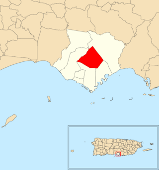
Playa Barrio is a barrio in the municipality of Santa Isabel, Puerto Rico. Its population in 2010 was 807.

<span class="mw-page-title-main">Hato Puerco Abajo</span> Barrio of Villalba, Puerto Rico

Hato Puerco is a barrio in the municipality of Villalba, Puerto Rico. Its population in 2010 was 1,764.

<span class="mw-page-title-main">Caguana, Utuado, Puerto Rico</span> Barrio of Puerto Rico

Caguana is a barrio in the municipality of Utuado, Puerto Rico. Its population in 2010 was 4,009.

<span class="mw-page-title-main">Boca Velázquez</span> Barrio of Santa Isabel, Puerto Rico

Boca Velázquez is a barrio in the municipality of Santa Isabel, Puerto Rico. Its population in 2010 was 2,705.

<span class="mw-page-title-main">Felicia 1</span> Barrio of Santa Isabel, Puerto Rico

Felicia 1 is a barrio in the municipality of Santa Isabel, Puerto Rico. Its population in 2010 was 530.

<span class="mw-page-title-main">Felicia 2</span> Barrio of Santa Isabel, Puerto Rico

Felicia 2 is a barrio in the municipality of Santa Isabel, Puerto Rico. Its population in 2010 was 3,230.

<span class="mw-page-title-main">Jauca 1</span> Barrio of Santa Isabel, Puerto Rico

Jauca 1 is a barrio in the municipality of Santa Isabel, Puerto Rico. Its population in 2010 was 2,177.

<span class="mw-page-title-main">Santa Isabel, Utuado, Puerto Rico</span> Barrio of Puerto Rico

Santa Isabel is a barrio in the municipality of Utuado, Puerto Rico. Its population in 2010 was 660.

<span class="mw-page-title-main">Santa Catalina, Coamo, Puerto Rico</span> Barrio of Puerto Rico

Santa Catalina is a barrio in the municipality of Coamo, Puerto Rico. Its population in 2010 was 1,788.

<span class="mw-page-title-main">Santa Rosa, Utuado, Puerto Rico</span> Barrio of Puerto Rico

Santa Rosa is a barrio in the municipality of Utuado, Puerto Rico. Its population in 2010 was 0.

<span class="mw-page-title-main">Plata, Lajas, Puerto Rico</span> Barrio of Puerto Rico

Plata is a barrio in the municipality of Lajas, Puerto Rico. Its population in 2010 was 2,620.

<span class="mw-page-title-main">Jobos, Guayama, Puerto Rico</span> Barrio of Puerto Rico

Jobos is a barrio in the municipality of Guayama, Puerto Rico. Its population in 2010 was 8,286.

<span class="mw-page-title-main">Hatillo, Hatillo, Puerto Rico</span> Barrio of Puerto Rico

Hatillo is a barrio in the municipality of Hatillo, Puerto Rico. Its population in 2010 was 3,806.

<span class="mw-page-title-main">Guamaní</span> Barrio of Guayama, Puerto Rico

Guamaní is a barrio in the municipality of Guayama, Puerto Rico. Its population in 2010 was 1,455.

<span class="mw-page-title-main">Rubias, Yauco, Puerto Rico</span> Barrio of Puerto Rico

Rubias is a barrio in the municipality of Yauco, Puerto Rico. Its population in 2010 was 309.

<span class="mw-page-title-main">Santa Cruz, Carolina, Puerto Rico</span> Barrio of Puerto Rico

Santa Cruz is a barrio in the municipality of Carolina, Puerto Rico. According to the 2010 Census, its population in that year was 1,927.

<span class="mw-page-title-main">Trujillo Bajo, Carolina, Puerto Rico</span> Barrio of Puerto Rico

Trujillo Bajo is a barrio in the municipality of Carolina, Puerto Rico. Its population in 2010 was 8,805.

<span class="mw-page-title-main">Callabo</span> Barrio of Juana Díaz, Puerto Rico

Callabo is a barrio in the municipality of Juana Díaz, Puerto Rico. Its population in 2010 was 2,237.

References

  1. 1 2 "US Gazetteer 2019". US Census. US Government.
  2. U.S. Geological Survey Geographic Names Information System: Santa Rosa barrio
  3. Picó, Rafael; Buitrago de Santiago, Zayda; Berrios, Hector H. Nueva geografía de Puerto Rico: física, económica, y social, por Rafael Picó. Con la colaboración de Zayda Buitrago de Santiago y Héctor H. Berrios. San Juan Editorial Universitaria, Universidad de Puerto Rico,1969.
  4. Gwillim Law (20 May 2015). Administrative Subdivisions of Countries: A Comprehensive World Reference, 1900 through 1998. McFarland. p. 300. ISBN   978-1-4766-0447-3 . Retrieved 25 December 2018.
  5. Puerto Rico: 2010 Population and Housing Unit Counts.pdf (PDF). U.S. Dept. of Commerce, Economics and Statistics Administration, U.S. Census Bureau. 2010.
  6. "Anuario del comercio, de la industria, de la magistratura y de la administración. 1881". Biblioteca Nacional de España (in Spanish). p. 1614. Retrieved 4 April 2023.
  7. Joseph Prentiss Sanger; Henry Gannett; Walter Francis Willcox (1900). Informe sobre el censo de Puerto Rico, 1899, United States. War Dept. Porto Rico Census Office (in Spanish). Imprenta del gobierno. p.  164.
  8. "Report of the Census of Porto Rico 1899". War Department Office Director Census of Porto Rico. Archived from the original on July 16, 2017. Retrieved September 21, 2017.
  9. "Table 3-Population of Municipalities: 1930 1920 and 1910" (PDF). United States Census Bureau. Archived (PDF) from the original on August 17, 2017. Retrieved September 21, 2017.
  10. "Table 4-Area and Population of Municipalities Urban and Rural: 1930 to 1950" (PDF). United States Census Bureau. Archived (PDF) from the original on August 30, 2015. Retrieved September 21, 2014.
  11. "Table 2 Population and Housing Units: 1960 to 2000" (PDF). United States Census Bureau. Archived (PDF) from the original on July 24, 2017. Retrieved September 21, 2017.
  12. Puerto Rico: 2010 Population and Housing Unit Counts.pdf (PDF). U.S. Dept. of Commerce Economics and Statistics Administration U.S. Census Bureau. 2010. Archived (PDF) from the original on 2017-02-20. Retrieved 2019-08-02.