Bajura, Isabela, Puerto Rico

Last updated
Bajura
Barrio
Buying drinks at Jobos Beach, Isabela, Puerto Rico.jpg
At the Rip Curl contest in 2003 at Jobos Beach in Bajura
Bajura, Isabela, Puerto Rico locator map.png
Location of Bajura within the municipality of Isabela shown in red
Caribbean location map.svg
Red pog.svg
Bajura
Location of Puerto Rico
Coordinates: 18°30′42″N67°03′53″W / 18.511704°N 67.064858°W / 18.511704; -67.064858 [1]
Commonwealth Flag of Puerto Rico.svg  Puerto Rico
Municipality Flag of Isabela.svg Isabela
Area
[1]
  Total4.89 sq mi (12.7 km2)
  Land1.61 sq mi (4.2 km2)
  Water3.28 sq mi (8.5 km2)
Elevation
[2]
7 ft (2 m)
Population
 (2010)
  Total663
  Density411.8/sq mi (159.0/km2)
 Source: 2010 Census
Time zone UTC−4 (AST)
ZIP Code
00662
Area code 787/939

Bajura is a barrio in the municipality of Isabela, Puerto Rico. Its population in 2010 was 663. [3] [4] [5]

Contents

History

Bajura was in Spain's gazetteers [6] until Puerto Rico was ceded by Spain in the aftermath of the Spanish–American War under the terms of the Treaty of Paris of 1898 and became an unincorporated territory of the United States. In 1899, the United States Department of War conducted a census of Puerto Rico finding that the population of Bajura barrio was 647. [7]

Historical population
CensusPop.Note
1900 647
1910 74515.1%
1920 713−4.3%
1930 607−14.9%
1940 71818.3%
1950 7321.9%
1960 542−26.0%
1970 408−24.7%
1980 400−2.0%
1990 46616.5%
2000 5017.5%
2010 66332.3%
U.S. Decennial Census
1899 (shown as 1900) [8] 1910-1930 [9]
1930-1950 [10] 1980-2000 [11] 2010 [12]

See also

Related Research Articles

<span class="mw-page-title-main">Turabo, Caguas, Puerto Rico</span> Barrio of Puerto Rico

Turabo or Villa Turabo is a barrio in the municipality of Caguas, Puerto Rico. Its population in 2010 was 15,739.

<span class="mw-page-title-main">Helechal, Barranquitas, Puerto Rico</span> Barrio of Puerto Rico

Helechal is a barrio in the municipality of Barranquitas, Puerto Rico. Its population in 2010 was 4,073.

<span class="mw-page-title-main">Coto, Isabela, Puerto Rico</span> Barrio of Puerto Rico

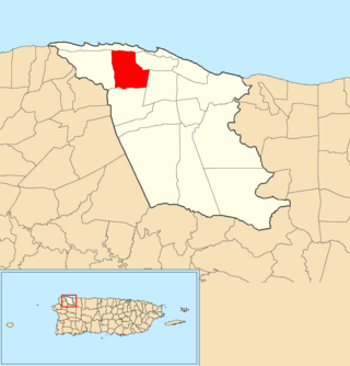
Coto is a barrio in the municipality of Isabela, Puerto Rico. Its population in 2010 was 3,575.

<span class="mw-page-title-main">Bajura, Cabo Rojo, Puerto Rico</span> Barrio of Puerto Rico

Bajura is a barrio in the municipality of Cabo Rojo, Puerto Rico. Its population in 2010 was 2,493.

<span class="mw-page-title-main">Bajura, Vega Alta, Puerto Rico</span> Barrio of Puerto Rico

Bajura is a barrio in the municipality of Vega Alta, Puerto Rico. Its population in 2010 was 3,725.

<span class="mw-page-title-main">Bajura Adentro</span> Barrio of Manatí, Puerto Rico

Bajura Adentro is a rural barrio in the municipality of Manatí, Puerto Rico. Its population in 2010 was 2,436.

<span class="mw-page-title-main">Bajura Afuera</span> Barrio of Manatí, Puerto Rico

Bajura Afuera is a rural barrio with an urban zone in the municipality of Manatí, Puerto Rico. Its population in 2010 was 677.

<span class="mw-page-title-main">Bejucos</span> Barrio of Isabela, Puerto Rico

Bejucos is a barrio in the municipality of Isabela, Puerto Rico. Its population in 2010 was 5,055.

<span class="mw-page-title-main">Galateo Alto</span> Barrio of Isabela, Puerto Rico

Galateo Alto is a barrio in the municipality of Isabela, Puerto Rico. Its population in 2010 was 1,314.

<span class="mw-page-title-main">Galateo Bajo</span> Barrio of Isabela, Puerto Rico

Galateo Bajo is a barrio in the municipality of Isabela, Puerto Rico. Its population in 2010 was 1,961.

<span class="mw-page-title-main">Guayabos</span> Barrio of Isabela, Puerto Rico

Guayabos is a barrio in the municipality of Isabela, Puerto Rico. Its population in 2010 was 1,475.

<span class="mw-page-title-main">Llanadas</span> Barrio of Isabela, Puerto Rico

Llanadas is a barrio in the municipality of Isabela, Puerto Rico. Its population in 2010 was 2,315.

<span class="mw-page-title-main">Planas</span> Barrio of Isabela, Puerto Rico

Planas is a barrio in the municipality of Isabela, Puerto Rico. Its population in 2010 was 2,075.

<span class="mw-page-title-main">Isabela barrio-pueblo</span> Historical and administrative center (seat) of Isabela, Puerto Rico

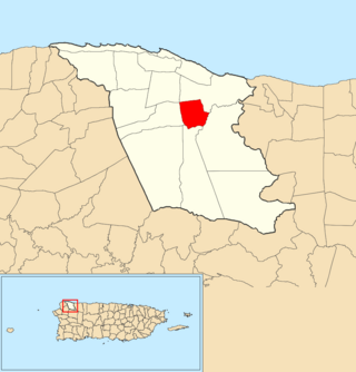
Isabela barrio-pueblo is a barrio and the administrative center (seat) of Isabela, a municipality of Puerto Rico. Its population in 2010 was 7,826.

<span class="mw-page-title-main">Jobos, Guayama, Puerto Rico</span> Barrio of Puerto Rico

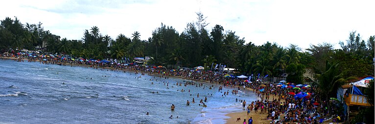
Jobos is a barrio in the municipality of Guayama, Puerto Rico. Its population in 2010 was 8,286.

<span class="mw-page-title-main">Jobos, Isabela, Puerto Rico</span> Barrio of Puerto Rico

Jobos is a barrio in the municipality of Isabela, Puerto Rico. Its population in 2010 was 3,446.

<span class="mw-page-title-main">Guerrero, Isabela, Puerto Rico</span> Barrio of Puerto Rico

Guerrero is a barrio in the municipality of Isabela, Puerto Rico. Its population in 2010 was 3,552.

<span class="mw-page-title-main">Mora, Isabela, Puerto Rico</span> Barrio of Puerto Rico

Mora is a barrio in the municipality of Isabela, Puerto Rico. Its population in 2010 was 4,682.

<span class="mw-page-title-main">Arenales Altos</span> Barrio of Isabela, Puerto Rico

Arenales Altos is a barrio in the municipality of Isabela, Puerto Rico. Its population in 2010 was 4,101.

<span class="mw-page-title-main">Arenales Bajos</span> Barrio of Isabela, Puerto Rico

Arenales Bajos is a barrio in the municipality of Isabela, Puerto Rico. Its population in 2010 was 3,591.

References

  1. 1 2 "US Gazetteer 2019". US Census. US Government.
  2. U.S. Geological Survey Geographic Names Information System: Bajura barrio
  3. Picó, Rafael; Buitrago de Santiago, Zayda; Berrios, Hector H. Nueva geografía de Puerto Rico: física, económica, y social, por Rafael Picó. Con la colaboración de Zayda Buitrago de Santiago y Héctor H. Berrios. San Juan Editorial Universitaria, Universidad de Puerto Rico,1969.
  4. Gwillim Law (20 May 2015). Administrative Subdivisions of Countries: A Comprehensive World Reference, 1900 through 1998. McFarland. p. 300. ISBN   978-1-4766-0447-3 . Retrieved 25 December 2018.
  5. Puerto Rico: 2010 Population and Housing Unit Counts.pdf (PDF). U.S. Dept. of Commerce, Economics and Statistics Administration, U.S. Census Bureau. 2010.
  6. "Anuario del comercio, de la industria, de la magistratura y de la administración. 1881". Biblioteca Nacional de España (in Spanish). p. 1614. Retrieved 4 April 2023.
  7. Joseph Prentiss Sanger; Henry Gannett; Walter Francis Willcox (1900). Informe sobre el censo de Puerto Rico, 1899, United States. War Dept. Porto Rico Census Office (in Spanish). Imprenta del gobierno. p.  160.
  8. "Report of the Census of Porto Rico 1899". War Department Office Director Census of Porto Rico. Archived from the original on July 16, 2017. Retrieved September 21, 2017.
  9. "Table 3-Population of Municipalities: 1930 1920 and 1910" (PDF). United States Census Bureau. Archived (PDF) from the original on August 17, 2017. Retrieved September 21, 2017.
  10. "Table 4-Area and Population of Municipalities Urban and Rural: 1930 to 1950" (PDF). United States Census Bureau. Archived (PDF) from the original on August 30, 2015. Retrieved September 21, 2014.
  11. "Table 2 Population and Housing Units: 1960 to 2000" (PDF). United States Census Bureau. Archived (PDF) from the original on July 24, 2017. Retrieved September 21, 2017.
  12. Puerto Rico: 2010 Population and Housing Unit Counts.pdf (PDF). U.S. Dept. of Commerce Economics and Statistics Administration U.S. Census Bureau. 2010. Archived (PDF) from the original on 2017-02-20. Retrieved 2019-08-02.