Utuado barrio-pueblo

Last updated
Utuado barrio-pueblo
Pueblo de Utuado
Municipality Seat [1]
UtuadoPuebloFeb2008.jpg
View of Utuado Pueblo from Sabana Grande
Utuado barrio-pueblo, Utuado, Puerto Rico locator map.png
Location of Utuado barrio-pueblo within the municipality of Utuado shown in red
Caribbean location map.svg
Red pog.svg
Utuado barrio-pueblo
Location of Puerto Rico
Coordinates: 18°15′57″N66°42′22″W / 18.265954°N 66.706242°W / 18.265954; -66.706242 [2]
Commonwealth Flag of Puerto Rico.svg  Puerto Rico
Municipality UtuadoFlag.svg Utuado
Area
[2]
  Total1.19 sq mi (3.1 km2)
  Land1.16 sq mi (3.0 km2)
  Water0.03 sq mi (0.08 km2)
Elevation
[3]
459 ft (140 m)
Population
 (2010)
  Total5,856
  Density5,048.3/sq mi (1,949.2/km2)
 Source: 2010 Census
Time zone UTC−4 (AST)

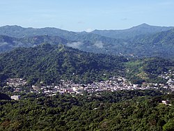
Utuado barrio-pueblo is a barrio and the administrative center (seat) of Utuado, a municipality of Puerto Rico. Its population in 2010 was 5,856. [1] [4] [5] [6]

Contents

The central plaza and its church

As was customary in Spain, in Puerto Rico, the municipality has a barrio called pueblo which contains a central plaza, the municipal buildings (city hall), and a Catholic church. Fiestas patronales (patron saint festivals) are held in the central plaza every year. [7] [8]

The central plaza, or square, is a place for official and unofficial recreational events and a place where people can gather and socialize from dusk to dawn. The Laws of the Indies, Spanish law, which regulated life in Puerto Rico in the early 19th century, stated the plaza's purpose was for "the parties" (celebrations, festivities) (Spanish : a propósito para las fiestas), and that the square should be proportionally large enough for the number of neighbors (Spanish : grandeza proporcionada al número de vecinos). These Spanish regulations also stated that the streets nearby should be comfortable portals for passersby, protecting them from the elements: sun and rain. [7]

Located across from the central plaza is the Parroquia San Miguel (Church San Miguel Arcángel of Utuado), the Roman Catholic parish church. [9] The first church to be built was made of wood and inaugurated in 1743. The current church was built from 1875 to 1896. [10] The church today is listed on the National Register of Historic Places. [11]

History

Utuado barrio-pueblo was in Spain's gazetteers [12] until Puerto Rico was ceded by Spain in the aftermath of the Spanish–American War under the terms of the Treaty of Paris of 1898 and became an unincorporated territory of the United States. In 1899, the United States Department of War conducted a census of Puerto Rico finding that the population of Utuado barrio-pueblo was 3,619. [13]

Historical population
CensusPop.Note
1900 3,619
1910 3,208−11.4%
1920 3,70015.3%
1930 4,75828.6%
1940 4,430−6.9%
1950 9,693118.8%
1960 9,8701.8%
1980 6,848
1990 4,980−27.3%
2000 5,3637.7%
2010 5,8569.2%
U.S. Decennial Census
1899 (shown as 1900) [14] 1910-1930 [15]
1930-1950 [16] 1980-2000 [17] 2010 [18]

See also

Related Research Articles

<span class="mw-page-title-main">Bayamón barrio-pueblo</span> Historical and administrative center (seat) of Bayamón, Puerto Rico

Bayamón barrio-pueblo is a barrio and the administrative center (seat) of Bayamón, a municipality of Puerto Rico. Its population in 2010 was 4,746.

<span class="mw-page-title-main">Naranjito barrio-pueblo</span> Historical and administrative center (seat) of Naranjito, Puerto Rico

Naranjito barrio-pueblo is a barrio and the administrative center (seat) of Naranjito, a municipality of Puerto Rico. Its population in 2010 was 1,157.

<span class="mw-page-title-main">Adjuntas barrio-pueblo</span> Historical and administrative center (seat) of Adjuntas, Puerto Rico

Adjuntas barrio-pueblo is a barrio and the administrative center (seat) of Adjuntas, a municipality of Puerto Rico. Its population in 2010 was 4,406.

<span class="mw-page-title-main">Coamo barrio-pueblo</span> Historical and administrative center (seat) of Coamo, Puerto Rico

Coamo barrio-pueblo is a barrio and the administrative center (seat) of Coamo, a municipality of Puerto Rico. Its population in 2010 was 6,685.

<span class="mw-page-title-main">Barranquitas barrio-pueblo</span> Historical and administrative center (seat) of Barranquitas, Puerto Rico

Barranquitas barrio-pueblo is a barrio and the administrative center (seat) of Barranquitas, a municipality of Puerto Rico. Its population in 2010 was 2,695.

<span class="mw-page-title-main">Yauco barrio-pueblo</span> Historical and administrative center (seat) of Yauco, Puerto Rico

Yauco barrio-pueblo is a barrio and the administrative center (seat) of Yauco, a municipality of Puerto Rico. Its population in 2010 was 3,091.

<span class="mw-page-title-main">Peñuelas barrio-pueblo</span> Historical and administrative center (seat) of Peñuelas, Puerto Rico

Peñuelas barrio-pueblo is a barrio and the administrative center (seat) of Peñuelas, a municipality of Puerto Rico. Its population in 2010 was 1,422.

<span class="mw-page-title-main">Arroyo barrio-pueblo</span> Historical and administrative center (seat) of Arroyo, Puerto Rico

Arroyo barrio-pueblo is a barrio and the administrative center (seat) of Arroyo, a municipality of Puerto Rico. Its population in 2010 was 1,206.

<span class="mw-page-title-main">Camuy barrio-pueblo</span> Historical and administrative center (seat) of Camuy, Puerto Rico

Camuy barrio-pueblo is a barrio and the administrative center (seat) of Camuy, a municipality of Puerto Rico. Its population in 2010 was 3,354.

<span class="mw-page-title-main">Guánica barrio-pueblo</span> Historical and administrative center (seat) of Guánica, Puerto Rico

Guánica barrio-pueblo is a barrio and the administrative center (seat) of Guánica, a municipality of Puerto Rico. Its population in 2010 was 3,514.

<span class="mw-page-title-main">Jayuya barrio-pueblo</span> Historical and administrative center (seat) of Jayuya, Puerto Rico

Jayuya barrio-pueblo is a barrio and the administrative center (seat) of Jayuya, a municipality of Puerto Rico. Its population in 2010 was 1,222.

<span class="mw-page-title-main">Moca barrio-pueblo</span> Historical and administrative center (seat) of Moca, Puerto Rico

Moca barrio-pueblo is a barrio and the administrative center (seat) of Moca, a municipality of Puerto Rico. Its population in 2010 was 1,735.

<span class="mw-page-title-main">Salinas barrio-pueblo</span> Historical and administrative center (seat) of Salinas, Puerto Rico

Salinas barrio-pueblo is a barrio and the administrative center (seat) of Salinas, a municipality of Puerto Rico. Its population in 2010 was 2,453.

<span class="mw-page-title-main">Santa Isabel barrio-pueblo</span> Historical and administrative center (seat) of Santa Isabel, Puerto Rico

Santa Isabel barrio-pueblo is a barrio and the administrative center (seat) of Santa Isabel, a municipality of Puerto Rico. Its population in 2010 was 5,133.

<span class="mw-page-title-main">Mayagüez barrio-pueblo</span> Historical and administrative center (seat) of Mayagüez, Puerto Rico

Mayagüez barrio-pueblo is a barrio and the administrative center (seat) of Mayagüez, a municipality of Puerto Rico. Its population in 2010 was 26,903.

<span class="mw-page-title-main">Juncos barrio-pueblo</span> Historical and administrative center (seat) of Juncos, Puerto Rico

Juncos barrio-pueblo is a barrio and the administrative center (seat) of Juncos, a municipality of Puerto Rico. Its population in 2010 was 2,464.

<span class="mw-page-title-main">Guayama barrio-pueblo</span> Historical and administrative center (seat) of Guayama, Puerto Rico

Guayama barrio-pueblo is a barrio and the administrative center (seat) of Guayama, a municipality of Puerto Rico. Its population in 2010 was 16,891.

<span class="mw-page-title-main">Lajas barrio-pueblo</span> Historical and administrative center (seat) of Lajas, Puerto Rico

Lajas barrio-pueblo is a barrio and the administrative center (seat) of Lajas, a municipality of Puerto Rico. Its population in 2010 was 564.

<span class="mw-page-title-main">San Germán barrio-pueblo</span> Historical and administrative center (seat) of San Germán, Puerto Rico

San Germán barrio-pueblo is a barrio and the administrative center (seat) of San Germán, a municipality of Puerto Rico. Its population in 2010 was 2,660.

<span class="mw-page-title-main">Luquillo barrio-pueblo</span> Historical and administrative center (seat) of Luquillo, Puerto Rico

Luquillo barrio-pueblo is a barrio and the administrative center (seat) of Luquillo, a municipality of Puerto Rico. Its population in 2010 was 1,028.

References

  1. 1 2 Puerto Rico: 2010 Population and Housing Unit Counts.pdf (PDF). U.S. Dept. of Commerce, Economics and Statistics Administration, U.S. Census Bureau. 2010.
  2. 1 2 "US Gazetteer 2019". US Census. US Government.
  3. U.S. Geological Survey Geographic Names Information System: Utuado barrio-pueblo
  4. Picó, Rafael; Buitrago de Santiago, Zayda; Berrios, Hector H. Nueva geografía de Puerto Rico: física, económica, y social, por Rafael Picó. Con la colaboración de Zayda Buitrago de Santiago y Héctor H. Berrios. San Juan Editorial Universitaria, Universidad de Puerto Rico,1969.
  5. Gwillim Law (20 May 2015). Administrative Subdivisions of Countries: A Comprehensive World Reference, 1900 through 1998. McFarland. p. 300. ISBN   978-1-4766-0447-3 . Retrieved 25 December 2018.
  6. "US Census Barrio-Pueblo definition". factfinder.com. US Census. Archived from the original on 13 May 2017. Retrieved 5 January 2019.
  7. 1 2 Santullano, Luis A. (10 March 2019). Mirada al Caribe. Vol. 54. Colegio de Mexico. pp. 75–78. doi:10.2307/j.ctvbcd2vs.12. JSTOR   j.ctvbcd2vs.12.
  8. Pariser, Harry S. (2003). Explore Puerto Rico, Fifth Edition . San Francisco: Manatee Press. pp.  52–55. Retrieved 10 February 2019.
  9. Marisa Gomez and Ester Cardona (July 1984). "National Register of Historic Places Inventory/Nomination: Thematic Nomination: Historic Churches of Puerto Rico". National Park Service . Retrieved June 5, 2023.
  10. Mari Mut, José A. (2013-08-28). Los Pueblos de Puerto Rico y Las Iglesias de Sus Plazas [The Pueblos of Puerto Rico, and the Churches of its Plazas] (PDF) (in Spanish). pp. 223–225. Retrieved 2021-01-22.
  11. "NPGallery Asset Detail". npgallery.nps.gov. Retrieved 2021-10-17.
  12. "Anuario del comercio, de la industria, de la magistratura y de la administración. 1881". Biblioteca Nacional de España (in Spanish). p. 1614. Retrieved 4 April 2023.
  13. Joseph Prentiss Sanger; Henry Gannett; Walter Francis Willcox (1900). Informe sobre el censo de Puerto Rico, 1899, United States. War Dept. Porto Rico Census Office (in Spanish). Imprenta del gobierno. p.  161.
  14. "Report of the Census of Porto Rico 1899". War Department Office Director Census of Porto Rico. Archived from the original on July 16, 2017. Retrieved September 21, 2017.
  15. "Table 3-Population of Municipalities: 1930 1920 and 1910" (PDF). United States Census Bureau. Archived (PDF) from the original on August 17, 2017. Retrieved September 21, 2017.
  16. "Table 4-Area and Population of Municipalities Urban and Rural: 1930 to 1950" (PDF). United States Census Bureau. Archived (PDF) from the original on August 30, 2015. Retrieved September 21, 2014.
  17. "Table 2 Population and Housing Units: 1960 to 2000" (PDF). United States Census Bureau. Archived (PDF) from the original on July 24, 2017. Retrieved September 21, 2017.
  18. Puerto Rico: 2010 Population and Housing Unit Counts.pdf (PDF). U.S. Dept. of Commerce Economics and Statistics Administration U.S. Census Bureau. 2010. Archived (PDF) from the original on 2017-02-20. Retrieved 2019-08-02.