Ocean Park (Santurce)

Last updated
Ocean Park
Ocean Park Rainbow.jpg
Rainbow over Ocean Park
Ocean Park (sub-barrio).png
Geolocation in Santurce
Ocean Park.png
2000 Census map
Commonwealth Flag of Puerto Rico.svg  Puerto Rico
Municipality Flag of San Juan, Puerto Rico.svg San Juan
Barrio Santurce
Area
[1]
  Total.83 sq mi (2.1 km2)
  Land.20 sq mi (0.5 km2)
  Water.63 sq mi (1.6 km2)
Elevation
[2]
0 ft (0 m)
Population
 (2010)
  Total1,667
  Density8,335/sq mi (3,218/km2)
 Source: 2010 Census
Time zone UTC−4 (AST)

Ocean Park is an upscale beachfront community within the barrio of Santurce, in the municipality of San Juan, Puerto Rico. It is one of the forty subbarrios of Santurce.

Contents

Demographics

In 2000, Ocean Park had a population of 1,976 and a land area of 0.52 square kilometres (0.20 sq mi). [3]

In 2010, Ocean Park had a population of 1,667 and a population density of 8,335 persons per square mile. [1]

Description

A man, wearing a mask, rides a bicycle in Ocean Park during the COVID-19 pandemic A man in a mask and in a bike.jpg
A man, wearing a mask, rides a bicycle in Ocean Park during the COVID-19 pandemic

About one kilometer off the beach is the small rocky Island Stone which is also part of the area, measuring about 100 by 50 meters.

Ocean Park is bound on the east by Calle Guerrero Noble and its straight extension to the beach, a short piece of Calle Cacique running east to connect to Calle Teniente Rivera, and the connecting piece of Calle Soldado Cruz to Calle Loíza. The southern border runs to Calle Loíza, but excluding same. In the west, it is Calle María Mozco (northern part) and Calle Santa Ana. The north is bordered by the beach and the Atlantic Ocean. Through the center runs Avenida McLeary where cafes, pubs and some services line the street.

Calle Loíza is a "trendy spot" with new businesses, bars, restaurants and boutiques. [4] [5]

Ocean Park is located between Condado and Isla Verde beaches making it an essential tranquil, tree-lined street residential neighborhood, with numerous examples of single-family homes from the decades between 1930 and 1950. Small bed-and-breakfast inns, which blend in with the residential community, dot the area. Its wide oceanfront and offshore reefs prevent large waves from reaching the beach, which is popular with trendy beachgoers. Strong seasonal onshore trade winds make the area popular for kitesurfing and windsurfing.

At the right of the barrio is the Parque Barbosa and the residential area of Santa Teresita, forming the eastern part of the barrio. Parque Barbosa, also known as Ultimo Trolley (Last Tram) is the home of the Ocean Park Marlins Futbol Club, a football team with categories from 5-year-old kids to "Superior" (semi-professional) both for female and male footballers. Último Trolley got its name because it was the last electric streetcar that crossed the streets of San Juan from 1901 to 1946 and was placed in the park and operated as a restaurant.[ citation needed ]

See also

Related Research Articles

<span class="mw-page-title-main">San Juan, Puerto Rico</span> Capital and largest city of Puerto Rico

San Juan is the capital city and most populous municipality in the Commonwealth of Puerto Rico, an unincorporated territory of the United States. As of the 2020 census, it is the 57th-largest city under the jurisdiction of the United States, with a population of 342,259. San Juan was founded by Spanish colonists in 1521, who called it Ciudad de Puerto Rico.

<span class="mw-page-title-main">Loíza, Puerto Rico</span> Town and municipality in Puerto Rico

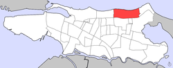
Loíza is a town and municipality on the northeastern coast of Puerto Rico, north of Canóvanas; east of Carolina, Puerto Rico; and west of Río Grande, Puerto Rico. Loíza is spread over five barrios and Loíza Pueblo. It is part of the San Juan-Caguas-Guaynabo Metropolitan Statistical Area. It is renowned for its rich Afro-Puerto Rican culture and heritage.

<span class="mw-page-title-main">Condado (Santurce)</span> Subbarrio of Santurce in San Juan, Puerto Rico

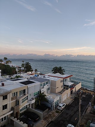
Condado is an oceanfront, tree-lined, pedestrian-oriented upper middle to upper class community in Santurce. It is one of the forty subbarrios of Santurce in San Juan, Puerto Rico.

<span class="mw-page-title-main">Isla Verde, Puerto Rico</span> Area of Carolina, Puerto Rico

Isla Verde is an area of Carolina located east of Santurce next to Luis Muñoz Marín International Airport above the Teodoro Moscoso Bridge. The area lies just outside the eastern border of San Juan, capital of Puerto Rico that links with the college town of Río Piedras and the residential counterpart surroundings of Hato Rey, which includes the neighborhoods of Baldrich and University Gardens revolving around Golden Mile's financial district.

<span class="mw-page-title-main">Santurce, San Juan, Puerto Rico</span> Barrio of Puerto Rico

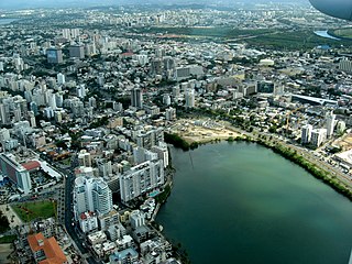
Santurce is a barrio or district in the municipality of San Juan. Its population in 2020 was 69,469. It is also the biggest and most populated of all the barrios in the capital city with a bigger population than most municipalities of Puerto Rico and one of the most densely populated areas of the island.

<span class="mw-page-title-main">Barrios of San Juan, Puerto Rico</span>

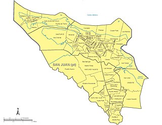
The municipality of San Juan is divided into 18 barrios, 16 of which fall within the former municipality of Río Piedras. Eight of the barrios are further divided into subbarrios, and they include the two barrios that originally composed the municipality of San Juan :

<span class="mw-page-title-main">Loíza (Santurce)</span> Subbarrio of Santurce in San Juan, Puerto Rico

Loíza is one of the forty subbarrios of Santurce, San Juan, Puerto Rico.

<span class="mw-page-title-main">Campo Alegre / Alto del Cabro (Santurce)</span> Subbarrios of Santurce in San Juan, Puerto Rico

Campo Alegre and Alto del Cabro are two subbarrios adjacent to each other with similar characteristics in the Barrio of Santurce. They have a combined land area of 0.28 square kilometres (0.11 sq mi) and a resident population of 2,106 as of the 2000 United States Census. They are located between Expreso Baldorioty de Castro to the north, Ponce de León Avenue to the south, Cerra Street to the west and Canals and Robles Streets to the east. These subbarrios, urbanized during the 19th century, are two of the oldest sections of Santurce. The perpendicular streets running north of Ponce de León Avenue are those corresponding to old toponymical alignments of the proprietors throughout Carretera Central.

<span class="mw-page-title-main">San Juan Police Department</span> Main police force for the city of San Juan, Puerto Rico

The San Juan Police Department is the primary law enforcement agency for the city of San Juan, PR, with jurisdiction only in the city limits of San Juan. It is also the largest municipal police force in the commonwealth, and the second largest of any police force in the commonwealth, after the Puerto Rico Police Department. It was created in 1977 under law #19 of May 12, 1977, known as the Municipal Police Law creating local police forces in each city of Puerto Rico.

<span class="mw-page-title-main">Las Marías (Santurce)</span> Subbarrio of Santurce in San Juan, Puerto Rico

Las Marías also known as Puntas las Marías is one of the forty subbarrios of Santurce, San Juan, Puerto Rico.

<span class="mw-page-title-main">Shanghai (Santurce)</span> Subbarrio of Santurce in San Juan, Puerto Rico

Shanghai is one of the 40 subbarrios of Santurce, a barrio of San Juan, Puerto Rico.

<span class="mw-page-title-main">Villa Palmeras (Santurce)</span> Subbarrio of Santurce in San Juan, Puerto Rico

Villa Palmeras is one of the forty subbarrios of Santurce, a barrio of San Juan, Puerto Rico.

<span class="mw-page-title-main">Tras Talleres (Santurce)</span> Subbarrio of Santurce in San Juan, Puerto Rico

Tras Talleres is one of the forty subbarrios of Santurce, San Juan, Puerto Rico. It comprises the area demarcated by the Luis Muñoz Rivera Expressway on the south, Calle Cerra on the west, Avenida Las Palmas on the north, and Avenida Roberto H. Todd on the east.

<span class="mw-page-title-main">Obrero (Santurce)</span> Subbarrio of Santurce in San Juan, Puerto Rico

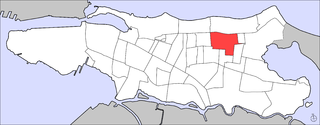
Obrero is one of 40 subbarrios of Santurce in the municipality of San Juan, Puerto Rico. Obrero is the most populated subbarrio in Santurce. The Residencial Las Casas public housing is located in the area.

<span class="mw-page-title-main">La Zona (Santurce)</span> Subbarrio of Santurce in San Juan, Puerto Rico

La Zona is one of the forty subbarrios of Santurce, San Juan, Puerto Rico.

<span class="mw-page-title-main">Buenos Aires (Santurce)</span> Subbarrio of Santurce in San Juan, Puerto Rico

Buenos Aires is one of the forty subbarrios of Santurce, San Juan, Puerto Rico.

<span class="mw-page-title-main">Parque (Santurce)</span> Subbarrio of Santurce in San Juan, Puerto Rico

Parque is one of the forty subbarrios of Santurce, San Juan, Puerto Rico. It is located between Condado and Ocean Park.

<span class="mw-page-title-main">Condado Beach</span> Place in San Juan, Puerto Rico

Condado Beach is a large public-access beach located in El Condado, a district of Santurce in San Juan, Puerto Rico. It is considered a dangerous beach with strong undercurrents.

<span class="mw-page-title-main">Ocean Park Beach</span> Place in San Juan, Puerto Rico

Ocean Park Beach is a large public-access beach located in Ocean Park, a neighborhood of the barrio (district) of Santurce in San Juan, Puerto Rico. The beach used to be known as Último Trolley Beach, since it was the site of the San Juan–Condado streetcar line terminal. A small section located closed to Dr. José Celso Barbosa Park is still referred to as El Último Trolley.

References

  1. 1 2 Puerto Rico 2010 population and housing unit counts.pdf (PDF). U.S. Dept. of Commerce, Economics and Statistics Administration, U.S. Census Bureau. 2010.
  2. U.S. Geological Survey Geographic Names Information System: Ocean Park Subbarrio
  3. Puerto Rico 2000: Population and Housing Unit Counts
  4. "Calle Loíza". Discover Puerto Rico. Retrieved February 3, 2022.
  5. Jackson, Jhoni (June 17, 2019). "A guide to local favorites in Calle Loíza". Washington Post. Retrieved February 3, 2022.

18°27′09″N66°02′59″W / 18.45250°N 66.04972°W / 18.45250; -66.04972