Algarrobo | |
|---|---|
Barrio | |
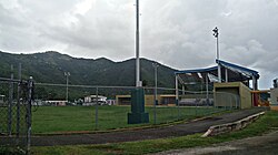 School grounds in Algarrobo in 2020 | |
 Location of Algarrobo within the municipality of Guayama shown in red | |
 Algarrobo Location of Puerto Rico | |
| Coordinates: 17°58′55″N66°05′05″W / 17.981984°N 66.084614°W [1] | |
| Commonwealth | |
| Municipality | |
| Area | |
• Total | 4.64 sq mi (12.0 km2) |
| • Land | 4.21 sq mi (10.9 km2) |
| • Water | 0.43 sq mi (1.1 km2) |
| Elevation | 102 ft (31 m) |
| Population (2010) | |
• Total | 6,959 |
| • Density | 1,656.9/sq mi (639.7/km2) |
| Source: 2010 Census | |
| Time zone | UTC−4 (AST) |
| ZIP Code | 00784 |
Algarrobo is a barrio in the municipality of Guayama, Puerto Rico. Its population in 2010 was 6,959. [3] [4] [5]
