Callejones

Last updated
Callejones
Barrio
Entrada al Parque de las Cavernas del Rio Camuy.jpg
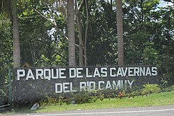
An entrance to the Camuy River Cave Park in Callejones
Callejones, Lares, Puerto Rico locator map.png
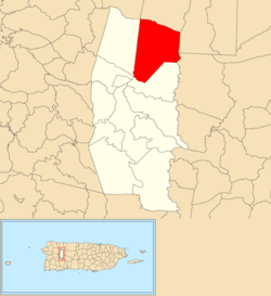
Location of Callejones barrio within the municipality of Lares shown in red
Caribbean location map.svg
Red pog.svg
Callejones
Location of Puerto Rico
Coordinates: 18°19′38″N66°50′56″W / 18.327225°N 66.848829°W / 18.327225; -66.848829 [1]
Commonwealth Flag of Puerto Rico.svg  Puerto Rico
Municipality Flag of Grito de Lares (current, medium blue).svg Lares
Area
[1]
  Total8.39 sq mi (21.7 km2)
  Land8.39 sq mi (21.7 km2)
  Water0 sq mi (0 km2)
Elevation
[2]
1,207 ft (368 m)
Population
 (2010)
  Total4,575
  Density545.3/sq mi (210.5/km2)
 Source: 2010 Census
Time zone UTC−4 (AST)

Callejones is a barrio in the municipality of Lares, Puerto Rico. Its population in 2010 was 4,575. [3] [4] [5] Machos Cave (Spanish : Cueva Machos) and Pajita Cave (Spanish : Cueva Pajita) are located in Callejones. [6]

Contents

History

Callejones was in Spain's gazetteers [7] until Puerto Rico was ceded by Spain in the aftermath of the Spanish–American War under the terms of the Treaty of Paris of 1898 and became an unincorporated territory of the United States. In 1899, the United States Department of War conducted a census of Puerto Rico finding that the population of Callejones barrio was 2,152. [8]

Historical population
CensusPop.Note
1900 2,152
1910 2,3519.2%
1920 2,4112.6%
1930 2,85518.4%
1940 3,35717.6%
1950 3,79813.1%
1960 2,958−22.1%
1970 2,412−18.5%
1980 2,76514.6%
1990 3,58429.6%
2000 4,36121.7%
2010 4,5754.9%
U.S. Decennial Census
1899 (shown as 1900) [9] 1910-1930 [10]
1930-1950 [11] 1980-2000 [12] 2010 [13]

Sectors

Barrios (which are, in contemporary times, roughly comparable to minor civil divisions) [14] and subbarrios, [15] in turn, are further subdivided into smaller local populated place areas/units called sectores (sectors in English). The types of sectores may vary, from normally sector to urbanización to reparto to barriada to residencial, among others. [16] [17] [18]

The following sectors are in Callejones barrio: [19]

Arco Iris, Berrocal, Camino Emau, Camino Julito Nieves, Carmelo Mercado, Copa de Oro, Demetrio Otaño, El Maná, Las Lajas, Los Adames, Los Chayotes, Los Luciano, Los Otaño, Miro Torres, Monchín Rivera, Sector Crematorio, Sector Cueva Pajita, Sector El 21, Sector El Taino, Sector Gregorio Rivera, Sector La Gallera, Sector La Pista, Sector La Sierra, Sector Las Campanas, Sector León Vega, Sector Los Nieves, Sector Los Santiago, Sector Pagán, Sector Pedro Colón, Sector Zenón Rivera, Sico Torres, Tramo Carretera 129, Tramo Carretera 134 , and Tramo Carretera 454.

Archeological site

An archeological site consisting of a batey (a large clearing where ceremonies took place) is located in Callejones. [20] It is of the Early Ostionoid (pre-Taino) (AD 600–1200) and Late Ostionoid (Taino) (AD 1200–1500) prehistoric eras and has been researched by Jose Oliver, a researcher from Yale University, [21] and Samuel Kirkland Lothrop. [22]

See also

Related Research Articles

<span class="mw-page-title-main">Lares, Puerto Rico</span> Town and municipality in Puerto Rico

Lares is a mountain town and municipality of Puerto Rico's central-western area. Lares is located north of Maricao and Yauco; south of Camuy, east of San Sebastián and Las Marias; and west of Hatillo, Utuado and Adjuntas. Lares is spread over 10 barrios and Lares Pueblo. It is part of the Aguadilla-Isabela-San Sebastián Metropolitan Statistical Area.

<span class="mw-page-title-main">Robles, Aibonito, Puerto Rico</span> Barrio of Puerto Rico

Robles is a barrio in the municipality of Aibonito, Puerto Rico. Its population in 2010 was 3,863.

<span class="mw-page-title-main">Bartolo, Lares, Puerto Rico</span> Barrio of Puerto Rico

Bartolo is a barrio in the municipality of Lares, Puerto Rico. Its population in 2010 was 2,035. Bartolo is on the southeastern border of Lares and Adjuntas.

<span class="mw-page-title-main">Buenos Aires, Lares, Puerto Rico</span> Barrio of Puerto Rico

Buenos Aires is a barrio in the municipality of Lares, Puerto Rico. Its population in 2010 was 2,291.

<span class="mw-page-title-main">La Torre, Lares, Puerto Rico</span> Barrio of Puerto Rico

La Torre is a barrio in the municipality of Lares, Puerto Rico. Its population in 2010 was 1,574.

<span class="mw-page-title-main">Lares, Lares, Puerto Rico</span> Barrio of Puerto Rico

Lares is a barrio in the municipality of Lares, Puerto Rico. Its population in 2010 was 3,405.

<span class="mw-page-title-main">Pezuela</span> Barrio of Lares, Puerto Rico

Pezuela is a barrio in the municipality of Lares, Puerto Rico. Its population in 2010 was 474. The barrio is divided into about 8 sectors. The barrio has been prone to landslides since Hurricane Maria struck in 2017.

<span class="mw-page-title-main">Piletas</span> Barrio of Lares, Puerto Rico

Piletas is a barrio in the municipality of Lares, Puerto Rico. Its population in 2010 was 5,671.

<span class="mw-page-title-main">Lares barrio-pueblo</span> Historical and administrative center (seat) of Lares, Puerto Rico

Lares barrio-pueblo is a barrio and the administrative center (seat) of Lares, a municipality of Puerto Rico. Its population in 2010 was 2,690.

<span class="mw-page-title-main">Cerro Gordo, Aguada, Puerto Rico</span> Barrio of Puerto Rico

Cerro Gordo is a barrio in the municipality of Aguada, Puerto Rico. Its population in 2010 was 3,018.

<span class="mw-page-title-main">Río Prieto, Lares, Puerto Rico</span> Barrio of Puerto Rico

Río Prieto is a barrio in the municipality of Lares, Puerto Rico. Its population in 2010 was 567.

<span class="mw-page-title-main">Pueblo, Lares, Puerto Rico</span> Barrio of Puerto Rico

Pueblo is a barrio in the municipality of Lares, Puerto Rico. Its population in 2010 was 4,838.

<span class="mw-page-title-main">Espino, Lares, Puerto Rico</span> Barrio of Puerto Rico

Espino is a barrio in the municipality of Lares, Puerto Rico. Its population in 2010 was 1,695.

<span class="mw-page-title-main">Morovis Sud</span> Barrio of Morovis, Puerto Rico

Morovis Sud also called Morovis Sur is a barrio in the municipality of Morovis, Puerto Rico. Morovis Sud has about 14 sectors and its population in 2010 was 4,208.

<span class="mw-page-title-main">Guaniquilla, Aguada, Puerto Rico</span> Barrio of Puerto Rico

Guaniquilla is a coastal barrio in the municipality of Aguada, Puerto Rico. Its population in 2010 was 2,663.

References

  1. 1 2 "US Gazetteer 2019". US Census. US Government. Archived from the original on 2020-01-16. Retrieved 2020-07-03.
  2. U.S. Geological Survey Geographic Names Information System: Callejones barrio
  3. Picó, Rafael; Buitrago de Santiago, Zayda; Berrios, Hector H. (1969). Nueva geografía de Puerto Rico: física, económica, y social, por Rafael Picó. Con la colaboración de Zayda Buitrago de Santiago y Héctor H. Berrios. San Juan Editorial Universitaria, Universidad de Puerto Rico,1969. Archived from the original on 2018-12-26. Retrieved 2019-01-03.
  4. Gwillim Law (20 May 2015). Administrative Subdivisions of Countries: A Comprehensive World Reference, 1900 through 1998. McFarland. p. 300. ISBN   978-1-4766-0447-3 . Retrieved 25 December 2018.
  5. Puerto Rico: 2010 Population and Housing Unit Counts.pdf (PDF). U.S. Dept. of Commerce, Economics and Statistics Administration, U.S. Census Bureau. 2010. Archived (PDF) from the original on 2017-02-20. Retrieved 2019-01-03.
  6. "Lares: Ciudad de cielos abiertos". Nueva Isla (in Spanish). SG Communications. Archived from the original on 2019-02-09. Retrieved 2019-03-03.
  7. "Anuario del comercio, de la industria, de la magistratura y de la administración. 1881". Biblioteca Nacional de España (in Spanish). p. 1614. Retrieved 4 April 2023.
  8. Joseph Prentiss Sanger; Henry Gannett; Walter Francis Willcox (1900). Informe sobre el censo de Puerto Rico, 1899, United States. War Dept. Porto Rico Census Office (in Spanish). Imprenta del gobierno. p.  160. Archived from the original on 2012-11-15. Retrieved 2020-03-11.
  9. "Report of the Census of Porto Rico 1899". War Department Office Director Census of Porto Rico. Archived from the original on July 16, 2017. Retrieved September 21, 2017.
  10. "Table 3-Population of Municipalities: 1930 1920 and 1910" (PDF). United States Census Bureau. Archived (PDF) from the original on August 17, 2017. Retrieved September 21, 2017.
  11. "Table 4-Area and Population of Municipalities Urban and Rural: 1930 to 1950" (PDF). United States Census Bureau. Archived (PDF) from the original on August 30, 2015. Retrieved September 21, 2014.
  12. "Table 2 Population and Housing Units: 1960 to 2000" (PDF). United States Census Bureau. Archived (PDF) from the original on July 24, 2017. Retrieved September 21, 2017.
  13. Puerto Rico: 2010 Population and Housing Unit Counts.pdf (PDF). U.S. Dept. of Commerce Economics and Statistics Administration U.S. Census Bureau. 2010. Archived (PDF) from the original on 2017-02-20. Retrieved 2019-08-02.
  14. "US Census Barrio-Pueblo definition". factfinder.com. US Census. Archived from the original on 13 May 2017. Retrieved 5 January 2019.
  15. "P.L. 94-171 VTD/SLD Reference Map (2010 Census): Lares Municipio, PR" (PDF). www2.census.gov. U.S. DEPARTMENT OF COMMERCE Economics and Statistics Administration U.S. Census Bureau. Archived (PDF) from the original on 22 August 2020. Retrieved 22 August 2020.
  16. "Agencia: Oficina del Coordinador General para el Financiamiento Socioeconómico y la Autogestión (Proposed 2016 Budget)". Puerto Rico Budgets (in Spanish). Archived from the original on 28 June 2019. Retrieved 28 June 2019.
  17. Rivera Quintero, Marcia (2014), El vuelo de la esperanza: Proyecto de las Comunidades Especiales Puerto Rico, 1997-2004 (first ed.), San Juan, Puerto Rico Fundación Sila M. Calderón, ISBN   978-0-9820806-1-0
  18. "Leyes del 2001". Lex Juris Puerto Rico (in Spanish). Archived from the original on 14 September 2018. Retrieved 24 June 2020.
  19. "PRECINTO ELECTORAL LARES 053" (PDF). Comisión Estatal de Elecciones (in Spanish). PR Government. 14 June 2019. Archived (PDF) from the original on 22 June 2020. Retrieved 19 June 2019.
  20. "Archived copy". Archived from the original on 2019-06-26. Retrieved 2019-06-26.{{cite web}}: CS1 maint: archived copy as title (link)
  21. Oliver, José R.; Rivera Fontán, Juan. "(2007) -NRHP Bateyes de Vivi (U-1), Utuado, Puerto Rico". Academia. Archived from the original on 22 August 2020. Retrieved 26 June 2019.
  22. "CALLEJONES SITE" (PDF). Agencias PR Gov. United States Department of the Interior, National Park Service. Retrieved 26 June 2019.