Beatriz, Caguas, Puerto Rico

Last updated
Beatriz
Barrio
Vista del area de Caguas desde el cerro las pinas - panoramio.jpg
View of Caguas from Cerro Las Piñas in Beatriz
Beatriz, Caguas, Puerto Rico locator map.png
Location of Beatriz within the municipality of Caguas shown in red
Caribbean location map.svg
Red pog.svg
Beatriz
Location of Puerto Rico
Coordinates: 18°10′23″N66°04′38″W / 18.173171°N 66.077086°W / 18.173171; -66.077086 [1]
Commonwealth Flag of Puerto Rico.svg  Puerto Rico
Municipality Bandera de Caguas, Puerto Rico.svg Caguas
Area
[1]
  Total6.13 sq mi (15.9 km2)
  Land6.13 sq mi (15.9 km2)
  Water0.00 sq mi (0.0 km2)
Elevation
[2]
725 ft (221 m)
Population
 (2020)
  Total3,281
  Density710.1/sq mi (274.2/km2)
 Source: 2010 Census
Time zone UTC−4 (AST)

Beatriz is a barrio in the municipality of Caguas, Puerto Rico. Its population in 2020 was 3,281. [3] [4] [5]

Contents

Geography

Beatriz is located at the coordinates 18°10′23″N66°4′37″W / 18.17306°N 66.07694°W / 18.17306; -66.07694 . According to the United States Census Bureau, Beatriz has a total area of 15.89 km², of which 15.89 km² is land and (0.03%) 0.01 km² is water. [6] Beatriz is located in the Sierra de Cayey, a subrange of the Cordillera Central mountain range, making it one of the barrios of Caguas which are not located in the Caguas Valley. The name of the barrio comes from the Doña Beatriz Creek which crosses it and flows into the Turabo River.

Sectors and demographics

Barrios (which are, in contemporary times, roughly comparable to minor civil divisions) [7] in turn are further subdivided into smaller local populated place areas/units called sectores (sectors in English). The types of sectores may vary, from normally sector to urbanización to reparto to barriada to residencial, among others. [8] [9] [10]

The following sectors are in Beatriz: Alturas de Beatriz, Alturas de Caguas (Beatriz), Barrio Beatriz, Colinas de Villa Coquí, La Jurado, Las Abejas, Los Ortíz, Los Panes, Muñoz Grillo, Piñas I, Piñas II, Piñas III, and Villa Paolo. [11]

According to the 2010 Census, there were 4,353 people residing in Beatriz. The population density was 27,391 inhabitants per km². Of 4,353 inhabitants, Beatriz was composed of 68.76% Whites, 13% were Black, 0.62% were American Indian, 0.05% were Asian, 0.02% were Pacific Islanders, 12.27% were of other races and 5.28% belonged to two or more races. In all, the population was 99.47% Hispanic or Latino. [6]

Historical population
CensusPop.Note
1900 868
1910 99014.1%
1920 2,727175.5%
1930 2,417−11.4%
1940 2,6047.7%
1950 2,7134.2%
1960 3,36524.0%
1970 3,262−3.1%
1980 3,5438.6%
1990 3,8077.5%
2000 4,46717.3%
2010 4,353−2.6%
2020 3,281−24.6%
U.S. Decennial Census
1899 (shown as 1900) [12] 1910-1930 [13]
1930-1950 [14] 1980-2000 [15] 2010 [16] 2020 [17]

History

Beatriz was in Spain's gazetteers [18] until Puerto Rico was ceded by Spain in the aftermath of the Spanish–American War under the terms of the Treaty of Paris of 1898 and became an unincorporated territory of the United States. In 1899, the United States Department of War conducted a census of Puerto Rico finding that the population of Beatriz barrio was 868. [19]

The area was mostly made up of subsistence farms in the 19th century. Botanist William Edwin Safford visited Beatriz in 1898 to document the local plant life. [20]

The 1899 San Ciriaco hurricane devastated Beatriz, and many farmers began working for the newly established military government of the United States of America building roads. [21] At the time, a store owned by wealthy landowner Don Ramón Álvarez was the center of economic life in Beatriz. In 1900, one of the store's cashiers Don Demetrio López was elected alcalde and comisario of Beatriz. [22]

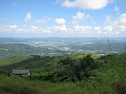
Beatriz barrio was hit by Hurricane Maria on 20 September 2017 and many residents still did not have electricity as of March 2018, six months later.

Landmarks and places of interest

See also

Related Research Articles

<span class="mw-page-title-main">Caguas, Puerto Rico</span> City and municipality in Puerto Rico

Caguas is a city and municipality of Puerto Rico located in the Central Mountain Range of Puerto Rico, south of San Juan and Trujillo Alto, west of Gurabo and San Lorenzo, and east of Aguas Buenas, Cidra, and Cayey. Caguas was founded in 1775. The municipality had a population of 127,244 at the 2020 census.

<span class="mw-page-title-main">Cayey, Puerto Rico</span> Town and municipality in Puerto Rico

Cayey, officially Cayey de Muesas, is a mountain town and municipality in central Puerto Rico located on the Sierra de Cayey within the Central Mountain range, north of Salinas and Guayama; south of Cidra and Caguas; east of Aibonito and Salinas; and west of San Lorenzo. Cayey is spread over 21 barrios plus Cayey Pueblo. It is part of the San Juan-Caguas-Guaynabo Metropolitan Statistical Area.

<span class="mw-page-title-main">San Lorenzo, Puerto Rico</span> Town and municipality in Puerto Rico

San Lorenzo is a town and municipality of Puerto Rico located in the eastern central region, north of Patillas and Yabucoa; south of Gurabo; east of Caguas and Cayey; and west of Juncos and Las Piedras. San Lorenzo is spread over twelve barrios and San Lorenzo Pueblo. It is part of the San Juan-Caguas-Guaynabo Metropolitan Statistical Area.

<span class="mw-page-title-main">Gurabo, Puerto Rico</span> Town and municipality in Puerto Rico

Gurabo is a town and municipality in eastern Puerto Rico. It is located in the central eastern region, north of San Lorenzo; south of Trujillo Alto; east of Caguas; and west of Carolina and Juncos. Gurabo is spread over 9 barrios and Gurabo Pueblo. It is part of the San Juan-Caguas-Guaynabo Metropolitan Statistical Area.

<span class="mw-page-title-main">Aguas Buenas, Puerto Rico</span> Town and municipality in Puerto Rico

Aguas Buenas,, popularly known as "La Ciudad de las Aguas Claras" or "The City of Clear Waters", is a town and municipality of Puerto Rico located in the Central Mountain Range, north of Cidra, south of Bayamón, Guaynabo and San Juan; east of Comerio; and north-west of Caguas. Aguas Buenas is spread over 9 barrios and Aguas Buenas Pueblo. It is part of the San Juan-Caguas-Guaynabo Metropolitan Statistical Area.

<span class="mw-page-title-main">Cañaboncito, Caguas, Puerto Rico</span> Barrio of Puerto Rico

Cañaboncito is a barrio in the municipality of Caguas, Puerto Rico. Its population in 2010 was 27,464. The barrio has over 90 sectors.

<span class="mw-page-title-main">Turabo, Caguas, Puerto Rico</span> Barrio of Puerto Rico

Turabo or Villa Turabo is a barrio in the municipality of Caguas, Puerto Rico. Its population in 2010 was 15,739.

<span class="mw-page-title-main">Borinquen, Caguas, Puerto Rico</span> Barrio of Puerto Rico

Borinquen is a barrio in the municipality of Caguas, Puerto Rico. Its population in 2010 was 7,953.

The barrios of Puerto Rico are the primary legal divisions of the seventy-eight municipalities of Puerto Rico. Puerto Rico's 78 municipios are divided into geographical sections called barrios and, as of 2010, there were 902 of them. In the US Census a barrio sometimes includes a division called a comunidad or subbarrio. In Puerto Rico, barrios are composed of sectors. The types of sectors, (sectores) may vary, from normally sector to urbanización to reparto to barriada to residencial, among others.

<span class="mw-page-title-main">Piñas, Comerío, Puerto Rico</span> Barrio of Puerto Rico

Piñas is a barrio in the municipality of Comerío, Puerto Rico. Its population in 2010 was 1,718.

<span class="mw-page-title-main">Piñas, Toa Alta, Puerto Rico</span> Barrio of Puerto Rico

Piñas is a barrio in the municipality of Toa Alta, Puerto Rico. Its population in 2010 was 1,354.

<span class="mw-page-title-main">Jaguas, Gurabo, Puerto Rico</span> Barrio of Puerto Rico

Jaguas is a barrio in the municipality of Gurabo, Puerto Rico. Its population in 2010 was 2,083.

<span class="mw-page-title-main">Jaguar, Gurabo, Puerto Rico</span> Barrio of Puerto Rico

Jaguar is a barrio in the municipality of Gurabo, Puerto Rico. Its population in 2010 was 735.

<span class="mw-page-title-main">Bairoa, Caguas, Puerto Rico</span> Barrio of Puerto Rico

Bairoa is a barrio or district in the municipality of Caguas, Puerto Rico. Its population in 2020 was 17,791. There are close to 60 sectors in Bairoa.

<span class="mw-page-title-main">Cayey barrio-pueblo</span> Historical and administrative center (seat) of Cayey, Puerto Rico

Cayey barrio-pueblo is a barrio and the administrative center (seat) of Cayey, a municipality of Puerto Rico. Its population in 2010 was 15,298.

<span class="mw-page-title-main">Caguas barrio-pueblo</span> Historical and administrative center (seat) of Caguas, Puerto Rico

Caguas Pueblo is a barrio and downtown area that serves the administrative center (seat) of the city and municipality of Caguas, a municipality of Puerto Rico. It is bordered by the Cagüitas River to the north and located two miles southwest of the Río Grande de Loíza. Its population in 2020 was 20,008.

<span class="mw-page-title-main">Beatriz, Cayey, Puerto Rico</span> Barrio of Puerto Rico

Beatriz is a barrio in the municipality of Cayey, Puerto Rico. Its population in 2010 was 3,027.

<span class="mw-page-title-main">Beatriz, Cidra, Puerto Rico</span> Barrio of Puerto Rico

Beatriz is a barrio in the municipality of Cidra, Puerto Rico. Its population in 2010 was 3,095.

<span class="mw-page-title-main">Ceiba, Cidra, Puerto Rico</span> Barrio in Cidra, Puerto Rico

Ceiba is a barrio in the municipality of Cidra, Puerto Rico. Its population in 2010 was 3,850.

<span class="mw-page-title-main">Guavate, Cayey, Puerto Rico</span> Barrio of Cayey, Puerto Rico

Guavate is a barrio in the municipality of Cayey, Puerto Rico. Its population in 2010 was 1,870.

References

  1. 1 2 "US Gazetteer 2019". US Census. US Government.
  2. U.S. Geological Survey Geographic Names Information System: Beatriz barrio
  3. Picó, Rafael; Buitrago de Santiago, Zayda; Berrios, Hector H. Nueva geografía de Puerto Rico: física, económica, y social, por Rafael Picó. Con la colaboración de Zayda Buitrago de Santiago y Héctor H. Berrios. San Juan Editorial Universitaria, Universidad de Puerto Rico,1969.
  4. Gwillim Law (20 May 2015). Administrative Subdivisions of Countries: A Comprehensive World Reference, 1900 through 1998. McFarland. p. 300. ISBN   978-1-4766-0447-3 . Retrieved 25 December 2018.
  5. "Census profile: Beatriz barrio, Caguas Municipio, PR". Census Reporter. Retrieved 2023-08-14.
  6. 1 2 Puerto Rico: 2010 Population and Housing Unit Counts.pdf (PDF). U.S. Dept. of Commerce, Economics and Statistics Administration, U.S. Census Bureau. 2010.
  7. "US Census Barrio-Pueblo definition". factfinder.com. US Census. Archived from the original on 13 May 2017. Retrieved 5 January 2019.
  8. "Agencia: Oficina del Coordinador General para el Financiamiento Socioeconómico y la Autogestión (Proposed 2016 Budget)". Puerto Rico Budgets (in Spanish). Retrieved 28 June 2019.
  9. Rivera Quintero, Marcia (2014), El vuelo de la esperanza: Proyecto de las Comunidades Especiales Puerto Rico, 1997-2004 (first ed.), San Juan, Puerto Rico Fundación Sila M. Calderón, ISBN   978-0-9820806-1-0
  10. "Leyes del 2001". Lex Juris Puerto Rico (in Spanish). Retrieved 24 June 2020.
  11. "Lista Sectores por Barrios Separados" (PDF). Municipio Autónomo de Caguas Oficina de Planificación Unidad de Información Geográfica y Estadísticas Vitales (in Spanish). Retrieved 7 January 2023.
  12. "Report of the Census of Porto Rico 1899". War Department Office Director Census of Porto Rico. Archived from the original on July 16, 2017. Retrieved September 21, 2017.
  13. "Table 3-Population of Municipalities: 1930 1920 and 1910" (PDF). United States Census Bureau. Archived (PDF) from the original on August 17, 2017. Retrieved September 21, 2017.
  14. "Table 4-Area and Population of Municipalities Urban and Rural: 1930 to 1950" (PDF). United States Census Bureau. Archived (PDF) from the original on August 30, 2015. Retrieved September 21, 2014.
  15. "Table 2 Population and Housing Units: 1960 to 2000" (PDF). United States Census Bureau. Archived (PDF) from the original on July 24, 2017. Retrieved September 21, 2017.
  16. Puerto Rico: 2010 Population and Housing Unit Counts.pdf (PDF). U.S. Dept. of Commerce Economics and Statistics Administration U.S. Census Bureau. 2010. Archived (PDF) from the original on 2017-02-20. Retrieved 2019-08-02.
  17. "PUERTO RICO: 2020 Census". U.S. Dept. of Commerce Economics and Statistics Administration U.S. Census Bureau. 2020.
  18. "Anuario del comercio, de la industria, de la magistratura y de la administración. 1881". Biblioteca Nacional de España (in Spanish). p. 1614. Retrieved 4 April 2023.
  19. Joseph Prentiss Sanger; Henry Gannett; Walter Francis Willcox (1900). Informe sobre el censo de Puerto Rico, 1899, United States. War Dept. Porto Rico Census Office (in Spanish). Imprenta del gobierno. p.  162.
  20. William Edwin Safford (April 1912). "Notes of a naturalist afloat". American Fern Journal. 2 (2): 40.
  21. Rosa E. Carrasquillo (2006). Our Landless Patria: Marginal Citizenship and Race in Caguas, Puerto Rico. University of Nebraska Press. p. 86. ISBN   0803215371.
  22. Rosa E. Carrasquillo (2006). Our Landless Patria: Marginal Citizenship and Race in Caguas, Puerto Rico. University of Nebraska Press. p. 32. ISBN   0803215371.