Monte Grande, Cabo Rojo, Puerto Rico

Last updated
Monte Grande
Barrio
Los Chorros, Cabo Rojo.jpg
Los Chorros in Monte Grande
Bandera del Barrio Monte Grande, Cabo Rojo.svg
Escudo de Monte Grande, Cabo Rojo.jpg
Monte Grande, Cabo Rojo, Puerto Rico locator map.png
Location of Monte Grande within the municipality of Cabo Rojo shown in red
Caribbean location map.svg
Red pog.svg
Monte Grande
Location of Puerto Rico
Coordinates: 18°04′29″N67°07′38″W / 18.074602°N 67.127356°W / 18.074602; -67.127356 [1]
Commonwealth Flag of Puerto Rico.svg  Puerto Rico
Municipality Flag of Cabo Rojo.svg Cabo Rojo
Area
[1]
  Total3.8 sq mi (10 km2)
  Land3.8 sq mi (10 km2)
  Water0.0 sq mi (0 km2)
Elevation
[2]
292 ft (89 m)
Population
 (2010)
  Total7,227
  Density1,901.8/sq mi (734.3/km2)
 Source: 2010 Census
Time zone UTC−4 (AST)
ZIP code
00623

Monte Grande is a barrio in the municipality of Cabo Rojo, Puerto Rico. Its population in 2010 was 7,227. [3] [4] [5]

Contents

Features

Quebrada Los Chorros is located in Monte Grande. [6]

History

The barrio was in Spain's gazetteers [7] until Puerto Rico was ceded by Spain in the aftermath of the Spanish–American War under the terms of the Treaty of Paris of 1898 and became an unincorporated territory of the United States. In 1899, the United States Department of War conducted a census of Puerto Rico finding that the population of Monte Grande barrio was 2,019. [8]

Historical population
CensusPop.Note
1900 2,019
1910 2,23310.6%
1920 2,3354.6%
1930 2,65413.7%
1940 3,76341.8%
1950 4,33515.2%
1960 4,4973.7%
1980 4,892
1990 5,2066.4%
2000 6,27520.5%
2010 7,22715.2%
U.S. Decennial Census
1899 (shown as 1900) [9] 1910-1930 [10]
1930-1950 [11] 1980-2000 [12] 2010 [13]

See also

Related Research Articles

<span class="mw-page-title-main">Llanos Costa, Cabo Rojo, Puerto Rico</span> Barrio of Puerto Rico

Llanos Costa is a barrio in the municipality of Cabo Rojo, Puerto Rico. Its population in 2010 was 3,571.

<span class="mw-page-title-main">Bajura, Cabo Rojo, Puerto Rico</span> Barrio of Puerto Rico

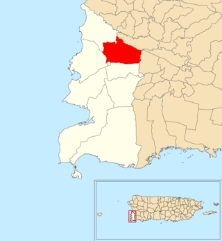
Bajura is a barrio in the municipality of Cabo Rojo, Puerto Rico. Its population in 2010 was 2,493.

<span class="mw-page-title-main">Capáez, Adjuntas, Puerto Rico</span> Barrio in Puerto Rico

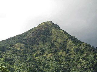
Capáez is a rural barrio in the municipality of Adjuntas, Puerto Rico. Its population in 2010 was 1,054.

<span class="mw-page-title-main">Guanajibo, Cabo Rojo, Puerto Rico</span> Barrio of Puerto Rico

Guanajibo is a barrio in the municipality of Cabo Rojo, Puerto Rico. Its population in 2010 was 4,905.

<span class="mw-page-title-main">Quebrada Grande, Mayagüez, Puerto Rico</span> Barrio of Puerto Rico

Quebrada Grande is a barrio in the municipality of Mayagüez, Puerto Rico. Its population in 2010 was 5,558.

<span class="mw-page-title-main">Cabo Caribe</span> Barrio of Vega Baja, Puerto Rico

Cabo Caribe is a barrio in the municipality of Vega Baja, Puerto Rico. Its population in 2010 was 3,989.

<span class="mw-page-title-main">Sabana Grande, Utuado, Puerto Rico</span> Barrio of Puerto Rico

Sabana Grande is a barrio in the municipality of Utuado, Puerto Rico. Its population in 2010 was 1,112.

<span class="mw-page-title-main">Llanos Tuna, Cabo Rojo, Puerto Rico</span> Barrio of Puerto Rico

Llanos Tuna is a barrio in the municipality of Cabo Rojo, Puerto Rico. Its population in 2010 was 6,183.

<span class="mw-page-title-main">Pedernales, Cabo Rojo, Puerto Rico</span> Barrio of Puerto Rico

Pedernales is a barrio in the municipality of Cabo Rojo, Puerto Rico. Its population in 2010 was 4,636.

<span class="mw-page-title-main">Cabo Rojo barrio-pueblo</span> Historical and administrative center (seat) of Cabo Rojo, Puerto Rico

Cabo Rojo barrio-pueblo is a barrio and the administrative center (seat) of Cabo Rojo, a municipality of Puerto Rico. Its population in 2010 was 1,078.

<span class="mw-page-title-main">Miradero, Cabo Rojo, Puerto Rico</span> Barrio of Puerto Rico

Miradero is a barrio in the municipality of Cabo Rojo, Puerto Rico. Its population in 2010 was 15,521. Joyuda, a small fishing village on Cabo Rojos' gastronomic route, is in Miradero.

<span class="mw-page-title-main">Quebrada Grande, Trujillo Alto, Puerto Rico</span> Barrio of Puerto Rico

Quebrada Grande is a barrio in the municipality of Trujillo Alto, Puerto Rico. Its population in 2010 was 4,376.

<span class="mw-page-title-main">Santana, Sabana Grande, Puerto Rico</span> Barrio of Puerto Rico

Santana is a barrio in the municipality of Sabana Grande, Puerto Rico. Its population in 2010 was 7,291.

<span class="mw-page-title-main">Monte Llano, Cayey, Puerto Rico</span> Barrio of Puerto Rico

Monte Llano is a barrio in the municipality of Cayey, Puerto Rico. Its population in 2010 was 3,302.

<span class="mw-page-title-main">Rincón, Cayey, Puerto Rico</span> Barrio of Puerto Rico

Rincón is a barrio in the municipality of Cayey, Puerto Rico. Its population in 2010 was 6,764.

<span class="mw-page-title-main">Peña Pobre</span> Barrio of Naguabo, Puerto Rico)

Peña Pobre is a barrio in the municipality of Naguabo, Puerto Rico. Its population in 2010 was 4,131.

<span class="mw-page-title-main">Machuchal, Sabana Grande, Puerto Rico</span> Barrio of Puerto Rico

Machuchal is a barrio in the municipality of Sabana Grande, Puerto Rico. Its population in 2010 was 4,773.

<span class="mw-page-title-main">Rayo, Sabana Grande, Puerto Rico</span> Barrio of Puerto Rico

Rayo is a barrio in the municipality of Sabana Grande, Puerto Rico. Its population in 2010 was 3,084.

<span class="mw-page-title-main">Sabana Grande Abajo</span> Barrio in San Germán, Puerto Rico

Sabana Grande Abajo is a barrio in the municipality of San Germán, Puerto Rico. Its population in 2010 was 2,712.

<span class="mw-page-title-main">Susúa</span> Barrio of Sabana Grande, Puerto Rico

Susúa is a barrio in the municipality of Sabana Grande, Puerto Rico. Its population in 2010 was 2,736.

References

  1. 1 2 "US Gazetteer 2019". US Census. US Government. Archived from the original on 2020-01-16. Retrieved 2020-06-28.
  2. U.S. Geological Survey Geographic Names Information System: Monte Grande barrio
  3. Picó, Rafael; Buitrago de Santiago, Zayda; Berrios, Hector H. Nueva geografía de Puerto Rico: física, económica, y social, por Rafael Picó. Con la colaboración de Zayda Buitrago de Santiago y Héctor H. Berrios. San Juan Editorial Universitaria, Universidad de Puerto Rico,1969.
  4. Gwillim Law (20 May 2015). Administrative Subdivisions of Countries: A Comprehensive World Reference, 1900 through 1998. McFarland. p. 300. ISBN   978-1-4766-0447-3 . Retrieved 25 December 2018.
  5. Puerto Rico: 2010 Population and Housing Unit Counts.pdf (PDF). U.S. Dept. of Commerce, Economics and Statistics Administration, U.S. Census Bureau. 2010. Archived (PDF) from the original on 2017-02-20. Retrieved 2019-01-04.
  6. Municipio de Cabo Rojo memoria Suplementaria Mapa de Limites Jurisdiccionales de Barrios (PDF) (1947 ed.). Junta de Plantificación, urbanización y zonificación de Puerto Rico. 1947. p. 20. Archived (PDF) from the original on 2021-09-04. Retrieved 2021-09-14.
  7. "Anuario del comercio, de la industria, de la magistratura y de la administración. 1881". Biblioteca Nacional de España (in Spanish). p. 1614. Retrieved 4 April 2023.
  8. Joseph Prentiss Sanger; Henry Gannett; Walter Francis Willcox (1900). Informe sobre el censo de Puerto Rico, 1899, United States. War Dept. Porto Rico Census Office (in Spanish). Imprenta del gobierno. p.  164.
  9. "Report of the Census of Porto Rico 1899". War Department Office Director Census of Porto Rico. Archived from the original on July 16, 2017. Retrieved September 21, 2017.
  10. "Table 3-Population of Municipalities: 1930 1920 and 1910" (PDF). United States Census Bureau. Archived (PDF) from the original on August 17, 2017. Retrieved September 21, 2017.
  11. "Table 4-Area and Population of Municipalities Urban and Rural: 1930 to 1950" (PDF). United States Census Bureau. Archived (PDF) from the original on August 30, 2015. Retrieved September 21, 2014.
  12. "Table 2 Population and Housing Units: 1960 to 2000" (PDF). United States Census Bureau. Archived (PDF) from the original on July 24, 2017. Retrieved September 21, 2017.
  13. Puerto Rico: 2010 Population and Housing Unit Counts.pdf (PDF). U.S. Dept. of Commerce Economics and Statistics Administration U.S. Census Bureau. 2010. Archived (PDF) from the original on 2017-02-20. Retrieved 2019-08-02.