Mameyes Abajo

Last updated
Mameyes Abajo
Barrio
Rio La Venta, Utuado, Puerto Rico.jpg
Río La Venta in Mameyes Abajo
Mameyes Abajo, Utuado, Puerto Rico locator map.png
Location of Mameyes Abajo within the municipality of Utuado shown in red
Caribbean location map.svg
Red pog.svg
Mameyes Abajo
Location of Puerto Rico
Coordinates: 18°18′10″N66°35′37″W / 18.302862°N 66.593509°W / 18.302862; -66.593509 [1]
Commonwealth Flag of Puerto Rico.svg  Puerto Rico
Municipality UtuadoFlag.svg Utuado
Area
[1]
  Total6.23 sq mi (16.1 km2)
  Land6.23 sq mi (16.1 km2)
  Water0 sq mi (0 km2)
Elevation
[2]
1,129 ft (344 m)
Population
 (2010)
  Total1,136
  Density182.3/sq mi (70.4/km2)
 Source: 2010 Census
Time zone UTC−4 (AST)

Mameyes Abajo is a barrio in the municipality of Utuado, Puerto Rico. Its population in 2010 was 1,136. [3] [4] [5] The corresponding Mameyes Arriba (Upper Mameyes) is located in neighbouring Jayuya at a higher elevation, but was once part of Utuado as well.

Contents

The Río La Venta is a river in Mameyes Abajo.

History

Mameyes Abajo was in Spain's gazetteers [6] until Puerto Rico was ceded by Spain in the aftermath of the Spanish–American War under the terms of the Treaty of Paris of 1898 and became an unincorporated territory of the United States. In 1899, the United States Department of War conducted a census of Puerto Rico finding that the population of Mameyes barrio was 4,268. [7]

Historical population
CensusPop.Note
1900 4,268
1910 1,535−64.0%
1920 1,79617.0%
1930 1,765−1.7%
1940 1,8303.7%
1950 1,445−21.0%
1960 1,181−18.3%
1970 1,075−9.0%
1980 1,033−3.9%
1990 1,0794.5%
2000 1,20711.9%
2010 1,136−5.9%
U.S. Decennial Census
1899 (shown as 1900) [8] 1910-1930 [9]
1930-1950 [10] 1980-2000 [11] 2010 [12]

See also

Related Research Articles

<span class="mw-page-title-main">Río Abajo, Utuado, Puerto Rico</span> Barrio of Puerto Rico

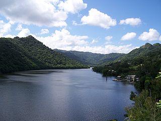
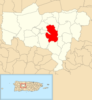
Río Abajo is a barrio in the municipality of Utuado, Puerto Rico. Its population in 2010 was 237. It is an isolated, rural barrio in the Cordillera Central, the mountain range that goes east to west across the center of Puerto Rico.

<span class="mw-page-title-main">Caonillas Abajo, Utuado, Puerto Rico</span> Barrio of Puerto Rico

Caonillas Abajo is a barrio in the municipality of Utuado, Puerto Rico. Its population in 2010 was 965.

<span class="mw-page-title-main">Caníaco, Utuado, Puerto Rico</span> Barrio of Puerto Rico

Caníaco is a barrio in the municipality of Utuado, Puerto Rico. Its population in 2010 was 198.

<span class="mw-page-title-main">Don Alonso</span> Barrio of Utuado, Puerto Rico

Don Alonso is a barrio in the municipality of Utuado, Puerto Rico. Its population in 2010 was 900.

<span class="mw-page-title-main">Guaonico</span> Barrio of Utuado, Puerto Rico

Guaonico is a barrio in the municipality of Utuado, Puerto Rico. Its population in 2010 was 538.

<span class="mw-page-title-main">Roncador, Utuado, Puerto Rico</span> Barrio of Puerto Rico

Roncador is a barrio in the municipality of Utuado, Puerto Rico. Its population in 2010 was 637.

<span class="mw-page-title-main">Salto Abajo</span> Barrio of Utuado, Puerto Rico

Salto Abajo is a barrio in the municipality of Utuado, Puerto Rico. Its population in 2010 was 3,929.

<span class="mw-page-title-main">Viví Abajo</span> Barrio of Utuado, Puerto Rico

Viví Abajo is a barrio in the municipality of Utuado, Puerto Rico. Its population in 2010 was 3,143.

<span class="mw-page-title-main">Viví Arriba</span> Barrio of Utuado, Puerto Rico

Viví Arriba is a barrio in the municipality of Utuado, Puerto Rico. Its population in 2010 was 748.

<span class="mw-page-title-main">Santa Isabel, Utuado, Puerto Rico</span> Barrio of Puerto Rico

Santa Isabel is a barrio in the municipality of Utuado, Puerto Rico. Its population in 2010 was 660.

<span class="mw-page-title-main">Mambiche</span> Barrio of Humacao, Puerto Rico

Mambiche is a barrio in the municipality of Humacao, Puerto Rico. Its population in 2010 was 2,387.

<span class="mw-page-title-main">Jayuya Abajo</span> Barrio of Jayuya, Puerto Rico

Jayuya Abajo is a barrio in the municipality of Jayuya, Puerto Rico. Its population in 2010 was 3,367.

<span class="mw-page-title-main">Frontón, Ciales, Puerto Rico</span> Barrio of Puerto Rico

Frontón is a barrio in the municipality of Ciales, Puerto Rico. Its population in 2010 was 2,228.

<span class="mw-page-title-main">Valenciano Abajo</span> Barrio of Juncos, Puerto Rico

Valenciano Abajo is a barrio in the municipality of Juncos, Puerto Rico. Its population in 2010 was 3,582.

<span class="mw-page-title-main">Gurabo Abajo</span> Barrio of Juncos, Puerto Rico

Gurabo Abajo is a barrio in the municipality of Juncos, Puerto Rico. Its population in 2010 was 4,857.

<span class="mw-page-title-main">Río Cañas Abajo, Juana Díaz, Puerto Rico</span> Barrio of Puerto Rico

Río Cañas Abajo is a barrio in the municipality of Juana Díaz, Puerto Rico. Its population in 2010 was 2,848.

<span class="mw-page-title-main">Río Cañas Abajo, Mayagüez, Puerto Rico</span> Barrio of Puerto Rico

Río Cañas Abajo is a barrio in the municipality of Mayagüez, Puerto Rico. Its population in 2010 was 2,459.

<span class="mw-page-title-main">Arenas, Utuado, Puerto Rico</span> Barrio of Puerto Rico

Arenas is a barrio in the municipality of Utuado, Puerto Rico. Its population in 2010 was 1,860.

<span class="mw-page-title-main">Sabana Abajo, Carolina, Puerto Rico</span> Barrio of Puerto Rico

Sabana Abajo is a barrio in the municipality of Carolina, Puerto Rico. Its population in 2010 was 55,600.

<span class="mw-page-title-main">Sabana Grande Abajo</span> Barrio in San Germán, Puerto Rico

Sabana Grande Abajo is a barrio in the municipality of San Germán, Puerto Rico. Its population in 2010 was 2,712.

References

  1. 1 2 "US Gazetteer 2019". US Census. US Government.
  2. U.S. Geological Survey Geographic Names Information System: Mameyes Abajo barrio
  3. Picó, Rafael; Buitrago de Santiago, Zayda; Berrios, Hector H. Nueva geografía de Puerto Rico: física, económica, y social, por Rafael Picó. Con la colaboración de Zayda Buitrago de Santiago y Héctor H. Berrios. San Juan Editorial Universitaria, Universidad de Puerto Rico,1969.
  4. Gwillim Law (20 May 2015). Administrative Subdivisions of Countries: A Comprehensive World Reference, 1900 through 1998. McFarland. p. 300. ISBN   978-1-4766-0447-3 . Retrieved 25 December 2018.
  5. Puerto Rico: 2010 Population and Housing Unit Counts.pdf (PDF). U.S. Dept. of Commerce, Economics and Statistics Administration, U.S. Census Bureau. 2010.
  6. "Anuario del comercio, de la industria, de la magistratura y de la administración. 1881". Biblioteca Nacional de España (in Spanish). p. 1614. Retrieved 4 April 2023.
  7. Joseph Prentiss Sanger; Henry Gannett; Walter Francis Willcox (1900). Informe sobre el censo de Puerto Rico, 1899, United States. War Dept. Porto Rico Census Office (in Spanish). Imprenta del gobierno. p.  161.
  8. "Report of the Census of Porto Rico 1899". War Department Office Director Census of Porto Rico. Archived from the original on July 16, 2017. Retrieved September 21, 2017.
  9. "Table 3-Population of Municipalities: 1930 1920 and 1910" (PDF). United States Census Bureau. Archived (PDF) from the original on August 17, 2017. Retrieved September 21, 2017.
  10. "Table 4-Area and Population of Municipalities Urban and Rural: 1930 to 1950" (PDF). United States Census Bureau. Archived (PDF) from the original on August 30, 2015. Retrieved September 21, 2014.
  11. "Table 2 Population and Housing Units: 1960 to 2000" (PDF). United States Census Bureau. Archived (PDF) from the original on July 24, 2017. Retrieved September 21, 2017.
  12. Puerto Rico: 2010 Population and Housing Unit Counts.pdf (PDF). U.S. Dept. of Commerce Economics and Statistics Administration U.S. Census Bureau. 2010. Archived (PDF) from the original on 2017-02-20. Retrieved 2019-08-02.