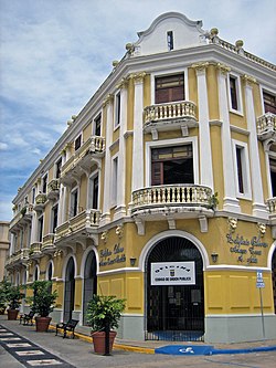
Casa del Rey is a historic building and former cabildo located in the historic center of Dorado, Puerto Rico. Throughout its history it has also been known as the Militia Guard Headquarters, Parador del Rey, and the Municipal Jail of Dorado.

Casa de Piedra, also known as Residencia Amparo Roldán, in Aguadilla, Puerto Rico, is a Spanish Colonial-style home that was erected in 1875. It is the only surviving residence of its era in Aguadilla; most similar ones were damaged in the 1918 San Fermín earthquake and eventually demolished.

District Courthouse, also known as Museo de Arte de Aguadilla, in Aguadilla, Puerto Rico, was built in 1925. It was listed on the National Register of Historic Places in 1985, and to the Puerto Rico Register of Historic Sites and Zones in 2000.
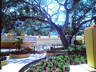
El Parterre is a landscaped park in Aguadilla, Puerto Rico, that was built in 1851. The park encloses the Ojo de Agua, also referred to as Manantial Ojo de Agua, a natural spring which was a source of water for Spanish soldiers, and the source of a small rivulet locally called Chico River which empties into the Aguadilla Bay.

The Fuerte de la Concepción was a Spanish military fortress guarding the port and town of Aguadilla, Puerto Rico, in the 18th and 19th centuries. In 1986, the fort's single surviving building was listed on the U.S. National Register of Historic Places, and later on the Puerto Rico Register of Historic Sites and Zones in 2000.
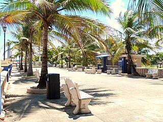
Paseo Víctor Rojas, also known as El Fuerte or Paseo de Damas, in Arecibo, Puerto Rico, was built in 1881. It was listed on the National Register of Historic Places in 1986, and on the Puerto Rico Register of Historic Sites and Zones in 2000.

Hacienda Santa Rita is located in the municipality of Guánica, Puerto Rico. It is also known as Casa Madre y Noviciado de las Hermanas Dominicas de Fatima and was built in 1800 by Don Mariano Quiñonez.

The Edificio José de Diego in Mayagüez, Puerto Rico, also known as the Rectoría, is a historic building on the grounds of the University of Puerto Rico at Mayagüez. It was built in 1913. It was listed on the National Register of Historic Places in 1977 and on the Puerto Rico Register of Historic Sites and Zones in 2000.

The Casa de la Diosa Mita was a house located in Arecibo barrio-pueblo in Arecibo, Puerto Rico. The house itself is unique because of its Beaux-Arts architectural design and was listed on the National Register of Historic Places on September 9, 1988. It was listed on the Puerto Rico Register of Historic Sites and Zones in 2000.

The Edificio Alcaldia is a historic building in Carolina, Puerto Rico. The building was designed by Puerto Rican architect Rafael Carmoega, then an architect of the Department of the Interior, with assistance of Francisco Garden. The Department of the Interior also built the building. In addition to serving as the City Hall, the facilities included government offices, the Municipal Jail, and a Medical Office.

Palacio del Marqués de las Claras or Casino de Arecibo, as it is also known, was built in 1888 by Fernando Fernández Umpierre, Marqués de las Claras. At the end of the 19th century, the Marqués de las Claras distinguished himself as one of the most prominent and wealthy owners of sugar estates in Puerto Rico. He was known for his sponsorship of the arts and cultural events.

Cambalache Bridge or Puente Francés is a bridge built in 1893 which spans the Río Grande de Arecibo from Cambalache barrio to Tanamá barrio in Arecibo. It is located 100 meters west of Puerto Rico Highway 2, at kilometer 72.

Gonzalo Marín 61 is a historic building located in the historic and administrative center of Arecibo, Puerto Rico. It was added to the United States National Register of Historic Places on October 19, 1986, and to the Puerto Rico Register of Historic Sites and Zones in 2000. Although an exact date of construction cannot be determined, based on historic photographs of the area, it can be said that the structure already existed on this lot by 1860. The historic building is currently abandoned.

Casa Alcaldía de Arecibo, formerly known as the Casa Consistorial, is the historic city hall and municipal administrative headquarters of the Puerto Rican municipality of Arecibo located in the Plaza Mayor in downtown Arecibo. Constructed by the Spanish between 1850 and 1866, more than 155 years ago, this government building exhibits the standard Neoclassic style that distinguishes the Spanish architecture of the time. The building was added to the National Register of Historic Places in 1986, and to the Puerto Rico Register of Historic Sites and Zones in 2000.

Casa Córdova, also known as Casa de las Conchas, is a historic building located at 14 Gonzalo Marín Street in the historic center of the Puerto Rican municipality of Arecibo. The historic residence, now a commercial building, was added to the United States National Register of Historic Places on November 17, 1986, and to the Puerto Rico Register of Historic Sites and Zones in 2000.
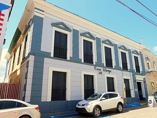
Casa Ulanga, also known as the former Superior Court of Arecibo, is a historic building located at 7 Gonzalo Marín Street in the historic center of the Puerto Rican municipality of Arecibo. Due to its historic and architectural importance the building was added to the United States National Register of Historic Places on July 26, 1982, and to the Puerto Rico Register of Historic Sites and Zones in 2000.
The Doña Antonia Ramírez Residence, also known as the Hernández Residence, is a historic Italianate-style residential building located in the Maguayo barrio of Dorado, Puerto Rico. The house was added to the United States National Register of Historic Places in 1988, and to the Puerto Rico Register of Historic Sites and Zones in 2000.
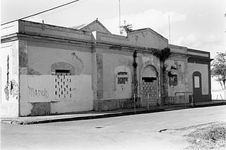
The Old Customs House of Humacao is a historic building located in Punta Santiago, in the municipality of Humacao, Puerto Rico. The structure was designed in the Spanish Colonial style, architecturally and typologically and finished in 1872 by the Department of Public Works of the Spanish Government in Puerto Rico. Until this time, the customs house was a temporary wooden building, so the need for a permanent structure made it possible that, in 1865, it was decided to construct the present building to serve as the new customs house at Punta Santiago.
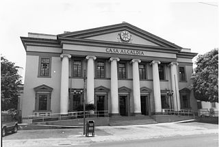
The Old District Courthouse of Humacao is a historic two-story concrete government building constructed in 1925 in the Neoclassical style located in Humacao Pueblo, in the Puerto Rican municipality of the same name. The building was designed by famed Puerto Rico State Architect Rafael Carmoega and built by the Public Buildings Division of the Department of Public Works.
The Puerto Rico Register of Historic Sites and Zones is a Puerto Rican government program adopted by the state Planning Board for use by both private and public entities to evaluate, register, revitalize, develop or protect the built historic and cultural heritage of Puerto Rico in the context and for the purpose of economic planning and land use zoning.
