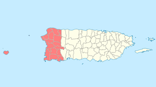
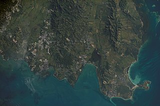
Cabo Rojo is a city and municipality situated on the southwest coast of Puerto Rico and forms part of the San Germán–Cabo Rojo metropolitan area as well as the larger Mayagüez–San Germán–Cabo Rojo Combined Statistical Area.
Caborrojeños Pro Salud y Ambiente, Inc. is a non-profit environmentalist organization based in Cabo Rojo, Puerto Rico.
Dr. Pedro Valle Carlo, is a retired college professor and noted environmentalist leader based in western Puerto Rico.

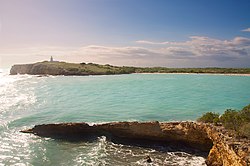
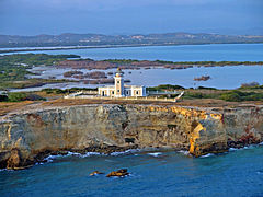
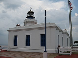
Faro Los Morrillos de Cabo Rojo, also known as Los Morrillos Light, is a historic lighthouse located in Los Morrillos cape in the municipality of Cabo Rojo, Puerto Rico.
Paradores in Puerto Rico is a brand of small inns similar to bed and breakfasts that have government permission to call themselves paradores based on a set of criteria. These inns are scattered across the island countryside, outside the main metropolitan area of San Juan. Often called "country inns" in English, paradores in Puerto Rico are known for their hospitality, affordable rates, exotic locations, and traditional Puerto Rican cuisine. They are frequented by guests looking to enjoy the local customs and charm.

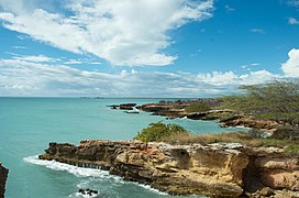
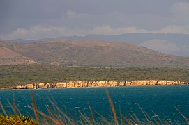
Puerto Rico Highway 301 (PR-301) is a main highway in Cabo Rojo, Puerto Rico. It begins in PR-101, close to PR-100, and goes south all the way to Los Morrillos Light, where it ends. It is the main access to the lighthouse, the Cabo Rojo cliffs, and Playa Sucia.

Boquerón is a barrio in the municipality of Cabo Rojo, Puerto Rico. Its population in 2010 was 5,373. The village of Boquerón, located on the Boquerón Bay is one of the main tourist attractions in the southwestern part of the island. In 2000, its population was 4,963.

Cabo Rojo National Wildlife Refuge is an 1,836-acre National Wildlife Refuge located in southwestern Puerto Rico, in the municipality of Cabo Rojo. The refuge is a habitat for number of native bird species including the endangered yellow-shouldered blackbird, locally known as mariquita de Puerto Rico or capitán. Many birds find their way to the refuge while migrating between North and South America, and more than 118 bird species have been recorded near the area.
Arecibo Light is a historic lighthouse located in the city of Arecibo, Puerto Rico. It is also known as Los Morrillos Lighthouse because of its location on top of a rocky headland known as Punta Morrillos. The lighthouse was constructed and lit in 1898. This was the last lighthouse built by the Spanish government on the island.

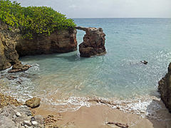
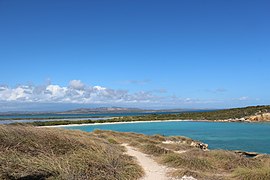
Isla de Ratones also known as Cayo Ratones or Isla Ratones is a small island located near the Joyuda Lagoon in Cabo Rojo, Puerto Rico. The island is a popular spot for snorkeling and bathing.
Porta del Sol is a tourism region in western Puerto Rico. It consists of 17 municipalities in the western area: Quebradillas, Isabela, San Sebastián, Moca, Aguadilla, Aguada, Rincón, Añasco, Mayagüez, Las Marías, Maricao, Hormigueros, San Germán, Sábana Grande, Guánica, Lajas and Cabo Rojo. Porta del Sol was established in 2003 by the Puerto Rico Tourism Company. The name translates to "Doorway to the Sun"

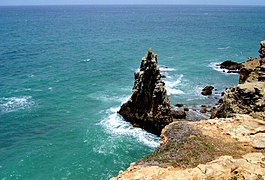
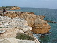
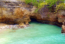
Boquerón State Forest is one of the 20 forestry units that make up the public forest system of Puerto Rico. Despite its name, the Boquerón State Forest is not only located in Boquerón, Cabo Rojo but also spans almost 5,000 acres across the municipalities of Cabo Rojo, Lajas and Mayagüez. The forest area is also known for its limestone cliffs, the lighthouse, and the salt flats which have been a source of salt since the pre-Hispanic era and, dating to 700 C.E., they are considered to be one of the oldest industries in the Americas.

Caja de Muertos Nature Reserve is a nature reserve in southern Puerto Rico consisting of the islands of Caja de Muertos, Cayo Morrillito, Cayo Berbería, and their surrounding reefs and waters in the Caribbean Sea. This nature reserve was founded on January 2, 1980, by the Puerto Rico Planning Board as recommended by the Puerto Rico Department of Natural and Environmental Resources with the purpose of preserving the subtropical dry forest ecosystems found within these islands, some important sea turtle nesting sites, and the marine habitats found on their surrounding reefs and waters.

Mona and Monito Islands Nature Reserve consists of two islands, Mona and Monito, in the Mona Passage off western Puerto Rico in the Caribbean. Mona and Monito Islands Nature Reserve encompasses both land and marine area, and with an area of 38,893 acres it is the largest protected natural area in the Commonwealth of Puerto Rico. Much like the Galapagos Islands in the Pacific Ocean, the Mona and Monito Islands reserve represents a living laboratory for archaeological, biological, geological, oceanographical and wildlife management research.

Hacienda Belvedere, also known as Finca Belvedere, is a former 1,649-acre plantation located in Miradero, in the municipality of Cabo Rojo, Puerto Rico. It was the second largest plantation in the region. There are debating theories as to the foundation and development of Hacienda Belvedere: one proposed by writer Ferreras Pagán states that the plantation was founded by the Cabassa brothers in the late 19th century, while local sources claim that it was founded in the early 19th century by the Monagas family. There is however no conflicting history regarding the hacienda's development during the early 20th century, when the plantation was owned and operated by the Vidal family until 1922, when it was leased to Manuel de Santiago of Hacienda Borinquen.
Boquerón Bay is a bay of the Mona Passage located on the coast of Cabo Rojo, Puerto Rico. El Poblado de Boquerón, or just Boquerón for short, located in the barrio of the same name, is the main settlement located along the bay. The bay is a major tourist destination as it hosts the Boquerón Beach and Los Pozos Beach. The Boquerón Lagoon and the Boquerón Iris Alameda Wildlife Refuge are located immediately to the east of the bay next to Boquerón Beach.
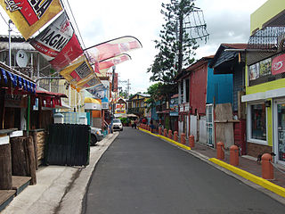
El Poblado de Boquerón is a coastal village which represents the downtown or main urban nucleus of the barrio (district) Boquerón of Cabo Rojo, located on the northeast of Boquerón Bay. The village is a major tourist destination, and it is renown in Puerto Rico for its gastronomy, boathouses, beach, nightlife and its yearly pride parade.