Mona Passage

Last updated
Mona Passage
Canal de la Mona
Mona passage.jpg
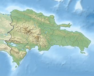
Location of the Mona Passage.
USA Puerto Rico topographic location map.png
Red pog.svg
Mona Passage
Coordinates 18°30′N67°53′W / 18.500°N 67.883°W / 18.500; -67.883
Basin  countries Puerto Rico (United States)
Dominican Republic

The Mona Passage (Spanish : Canal de la Mona) is a strait that separates the islands of Hispaniola and Puerto Rico. The Mona Passage connects the Atlantic Ocean to the Caribbean Sea and is an important shipping route between the Atlantic and the Panama Canal.

Contents

The Mona Passage is 80 miles (130 kilometers) long. It is fraught with variable tidal currents created by large islands on either side of it, and by sand banks that extend out from both coasts.

Islands

There are three small islands in the Mona Passage:

Structure and seismicity

The Passage was the site of a devastating earthquake and resulting tsunami that hit western Puerto Rico in 1918. [1] It is the site of frequent small earthquakes. The passage is underlain by a seismically active rift zone that overprints an older partly eroded tilted-block structure. [1] Desecheo Island sits on the Desecheo ridge, a narrow east–west ridge that extends west from the northwest corner of Puerto Rico. The ridge forms the southern boundary of the 13,123 ft (4,000 m) deep Mona Canyon which extends toward the north into the Puerto Rico Trench. The east face of the rift has a sharp relief of 3 km and is controlled by the N - S trending Mona Rift Fault. The epicenter of the 1918 earthquake was located along the east or southeast edge of the Mona Rift. [2]

Physical oceanography

The Mona Passage connects the Atlantic Ocean waters and Caribbean Sea waters, above a sill depth of 1,312 to 1,640 feet (400 to 500 meters). The sill runs along a northwest to the southeast direction between Cabo Engaño in Hispaniola in the west and the Cabo Rojo Shelf in Puerto Rico to the east margin of the Mona Passage. The vertical profile of the low-frequency (periods longer than 2 days) mean meridional water transport is characterized by a two-layer structure. The upper layer lies above a depth of 984 feet (300 meters), with the upper water masses, the Caribbean Surface Water, Subtropical Underwater and Sargasso Sea Water entering the Caribbean Sea from the Atlantic Ocean. Below this layer, the Tropical Central Water exits toward the Atlantic Ocean. The mean value for the meridional (North-South) transport for a sampled year was -1.85 ± 0.25 sverdrup (Sv) into the Caribbean Sea. [3]

The barotropic tide (surface tide) propagates from northeast to southwest along Mona Passage. The "principal lunar semi-diurnal" constituent, also known as the M2 (or M2) accounts for 52.35% of the total variance observed in the ocean currents and the semidiurnal current ellipses, with a clockwise rotation, are roughly aligned in a north–south direction. [4]

Semidiurnal tidal currents impinging on a submarine ridge known as El Pichincho can force the generation of an internal tide with a wave height of 131 feet (40 meters). [5] Underwater glider observations reveal wave damping as the internal tide propagates south along the Mona Passage towards the open Caribbean Sea. [6] [7] [8]

Internal tides at El Pichincho can elevate the turbulent vertical diffusivity values (or Eddy diffusion), and with a reduction of the Richardson number at the base of the pycnocline. The development of Kelvin-Helmholtz instability during the breaking of the internal tide can explain the formation of high diffusivity patches that generate a vertical flux of nitrate (NO3) into the photic zone and can sustain new production locally. [9]

Higher values of primary productivity were observed near the wave trough, than those observed during periods of maximum solar irradiance at noon.

Images from the Moderate-Resolution Imaging Spectroradiometer (MODIS) and International Space Station (ISS) photography show the sea-surface manifestation of packets of internal solitons (or nonlinear internal waves) generated at Banco Engaño, located at the northwest margin of the Mona Passage. [10] [11]

The packets propagate either into the Caribbean Sea or the Atlantic Ocean depending on the direction of the currents that forced their generation. [12]

Surface tides, internal tides, internal solitons, inertial currents and the low frequency water mass transport between the Atlantic Ocean and the Caribbean Sea make the Mona Passage a very dynamic environment.

See also

Related Research Articles

<span class="mw-page-title-main">Caribbean Sea</span> Sea of the Atlantic Ocean bounded by North, Central, and South America

The Caribbean Sea is a sea of the North Atlantic Ocean in the tropics of the Western Hemisphere, located south of the Gulf of Mexico and southwest of the Sargasso Sea. It is bounded by the Greater Antilles to the north from Cuba to Puerto Rico, the Lesser Antilles to the east from the Virgin Islands to Trinidad and Tobago, South America to the south from the Venezuelan coastline to the Colombian coastline, and Central America and the Yucatán Peninsula to the west from Panama to Mexico. The geopolitical region centered around the Caribbean Sea, including the numerous islands of the West Indies and adjacent coastal areas in the mainland of the Americas, is known as the Caribbean.

<span class="mw-page-title-main">Geography of Puerto Rico</span>

Puerto Rico, officially the Commonwealth of Puerto Rico, is an archipelagic island U.S. territory comprised of the eponymous main island of Puerto Rico and 142 smaller islands, including Vieques, Culebra, and Mona. It is located between the Greater and Lesser Antilles in the northeastern Caribbean Sea, east of Hispaniola, west of Saint Thomas, north of Venezuela, and south of the Puerto Rico Trench. Measuring 177 km in length and 65 km in width with a land area of 8,868 sq km, the main island is the 3rd largest in the U.S., 4th in the Caribbean, 29th in the Americas, and 81st in the world, making it the 174th largest country or dependency by surface area. With 3.2 million residents, it is the 2nd largest in the U.S., 4th in the Caribbean, 4th in the Americas, and 31st in the world, making it the 136th largest country or dependency by population.

<span class="mw-page-title-main">Mayagüez, Puerto Rico</span> City and municipality in Puerto Rico

Mayagüez is the ninth-largest municipality in Puerto Rico. It was founded as Pueblo de Nuestra Señora de la Candelaria de Mayagüez, and is also known as La Sultana del Oeste, Ciudad de las Aguas Puras, or Ciudad del Mangó. On April 6, 1894, the Spanish Crown granted it the formal title of Excelente Ciudad de Mayagüez. Mayagüez is located in the center of the western coast on the island of Puerto Rico. It has a population of 73,077, and it is the principal city of the Mayagüez Metropolitan Statistical Area and the Mayagüez–Aguadilla, PR Combined Statistical Area.

<span class="mw-page-title-main">Isla de Mona</span> Island of Puerto Rico

Mona Island is the third-largest island of the Puerto Rican archipelago, after the main island of Puerto Rico and Vieques. It is the largest of three islands in the Mona Passage, the strait between Hispaniola and Puerto Rico, with the others being Monito Island and Desecheo Island. It measures about 7 miles by 4 miles, and lies 41 mi (66 km) west of Puerto Rico, of which it is administratively a part. It is one of two islands that make up the Isla de Mona e Islote Monito barrio in the municipality of Mayagüez.

<span class="mw-page-title-main">Seiche</span> Standing wave in an enclosed or partially enclosed body of water

A seiche is a standing wave in an enclosed or partially enclosed body of water. Seiches and seiche-related phenomena have been observed on lakes, reservoirs, swimming pools, bays, harbors, caves, and seas. The key requirement for formation of a seiche is that the body of water be at least partially bounded, allowing the formation of the standing wave.

<span class="mw-page-title-main">Windward Passage</span> Strait in the Caribbean Sea, between the islands of Cuba and Hispaniola

Windward Passage is a strait in the Caribbean Sea, between the islands of Cuba and Hispaniola. The strait specifically lies between the easternmost region of Cuba and the northwest of Haiti. 80 km (50 mi) wide, the Windward Passage has a threshold depth of 1,700 m (5,600 ft).

<span class="mw-page-title-main">Puerto Rican dry forests</span> Dry forests in southern Puerto Rico

The Puerto Rican dry forests are a tropical dry forest ecoregion located in southwestern and eastern Puerto Rico and on the offshore islands. They cover an area of 1,300 km2 (500 sq mi). These forests grow in areas receiving less than 1,000 mm (39 in) of rain annually. Many of the trees are deciduous, losing their leaves during the dry season which normally lasts from December to April.

<span class="mw-page-title-main">Puerto Rico Trench</span> Oceanic trench on a transform boundary between the Caribbean and North American plates

The Puerto Rico Trench is located on the boundary between the North Atlantic Ocean and Caribbean Sea, parallel to and north of Puerto Rico, where the oceanic trench reaches the deepest points in the Atlantic Ocean. The trench is associated with a complex transition from the Lesser Antilles frontal subduction zone between the South American plate and Caribbean plate to the oblique subduction zone and the strike-slip transform fault zone between the North American plate and Caribbean plate, which extends from the Puerto Rico Trench at the Puerto Rico–Virgin Islands microplate through the Cayman Trough at the Gonâve microplate to the Middle America Trench at the Cocos plate.

<span class="mw-page-title-main">Desecheo Island</span> Uninhabited island of Puerto Rico

Desecheo is a small uninhabited island of the archipelago of Puerto Rico in the northeast of the Mona Passage; 13 mi (21 km) from the municipality of Rincón on the west coast of the main island of Puerto Rico and 31 mi (50 km) northeast of Mona Island. It has a land area of 0.589 sq mi. Politically, the island is administered by the U.S. Department of the Interior, U.S. Fish and Wildlife Service as the Desecheo National Wildlife Refuge, but part of the Sabanetas barrio of Mayagüez.

<span class="mw-page-title-main">Anegada Passage</span> Strait in the Caribbean

The Anegada Passage, also known as the Anegada Trough, is a strait in the Caribbean that separates the British Virgin Islands and the British ruled Sombrero Island of Anguilla, and connects the Caribbean and the Atlantic Ocean. It is 2300 m deep. Because the threshold depths are 1800 and 1600 m, Atlantic deep water from 1600 m level may flow into the deep areas in the Caribbean Sea.

USCGC <i>Escanaba</i> (WMEC-907)

USCGC Escanaba (WMEC-907) is a United States Coast Guard medium endurance cutter based in Portsmouth, Virginia. Her keel was laid on April 1, 1983, at Robert Derecktor Shipyard Incorporated, Middletown, Rhode Island. She was launched February 6, 1985 and is named for her predecessor, USCGC Escanaba (WPG-77) which sank during World War Two, and was named for the Escanaba River and Escanaba, Michigan. Escanaba (WMEC-907) was formally commissioned August 29, 1987 in Grand Haven, Michigan, the home port of her predecessor.

The 1918 San Fermín earthquake, also known as the Puerto Rico earthquake of 1918, struck the island of Puerto Rico at 10:14:42 local time on October 11. The earthquake measured 7.1 on the moment magnitude scale and IX (Violent) on the Mercalli intensity scale. The mainshock epicenter occurred off the northwestern coast of the island, somewhere along the Puerto Rico Trench.

Internal tides are generated as the surface tides move stratified water up and down sloping topography, which produces a wave in the ocean interior. So internal tides are internal waves at a tidal frequency. The other major source of internal waves is the wind which produces internal waves near the inertial frequency. When a small water parcel is displaced from its equilibrium position, it will return either downwards due to gravity or upwards due to buoyancy. The water parcel will overshoot its original equilibrium position and this disturbance will set off an internal gravity wave. Munk (1981) notes, "Gravity waves in the ocean's interior are as common as waves at the sea surface-perhaps even more so, for no one has ever reported an interior calm."

<span class="mw-page-title-main">Isla de Mona e Islote Monito, Mayagüez, Puerto Rico</span> Barrio of Puerto Rico

Isla de Mona e Islote Monito is an island-barrio of Mayagüez, Puerto Rico. The U.S. census of 2000 reports six housing units, but a population of zero. The barrio is made up of the islands of Mona and Monito. In 2010, there was a population of 5. This is the largest barrio of Mayagüez by area. The total land area of both islands in the barrio is about 56.93 km2, and it comprises 28.3 percent of the total land area of the municipality of Mayagüez. Desecheo Island, 49 km to the northeast, is part of Sabanetas barrio. The Mona Island Lighthouse is located in the barrio. Isla de Mona e Islote Monito is surrounded by the Mona Passage.

<span class="mw-page-title-main">Porta del Sol</span> Tourism region in western Puerto Rico

Porta del Sol, or simply West Region, is a tourism region in western Puerto Rico. Porta del Sol was the first tourism region to be established by the Puerto Rico Tourism Company. It consists of 17 municipalities in the western area: Quebradillas, Isabela, San Sebastián, Moca, Aguadilla, Aguada, Rincón, Añasco, Mayagüez, Las Marías, Maricao, Hormigueros, San Germán, Sabana Grande, Guánica, Lajas and Cabo Rojo.

<span class="mw-page-title-main">Sabanetas, Mayagüez, Puerto Rico</span> Barrio of Puerto Rico

Sabanetas is a barrio in the municipality of Mayagüez, Puerto Rico. Its population in 2010 was 4,005.

<span class="mw-page-title-main">American Mediterranean Sea</span> Mediterranean dilution basin covering the Gulf of Mexico and Caribbean Sea

The American Mediterranean Sea is a scientific name for the mediterranean dilution basin which includes the Caribbean Sea and the Gulf of Mexico. The name, which has been employed particularly by German oceanographers, is not recognized by the USGS, the International Hydrographic Organization or other international hydrological bodies.

USCGC <i>Heriberto Hernandez</i> Sentinel-class cutter

USCGC Heriberto Hernandez is the 14th Sentinel-class cutter delivered to the United States Coast Guard. Like five of her sister ships, her initial assignment will see her based in San Juan, Puerto Rico.

<span class="mw-page-title-main">Mona Canyon</span> Submarine canyon in the Mona Passage

Mona Canyon, also known as the Mona Rift, is an 87-mile long (140 km) submarine canyon located in the Mona Passage, between the islands of Hispaniola and Puerto Rico, with steep walls measuring between 1.25 and 2.17 miles (2-3.5 km) in height from bottom to top. The Mona Canyon stretches from the Desecheo Island platform, specifically the Desecheo Ridge, in the south to the Puerto Rico Trench, which contains some of the deepest points in the Atlantic Ocean, in the north. The canyon is also particularly associated with earthquakes and subsequent tsunamis, with the 1918 Puerto Rico earthquake having its epicenter in the submarine canyon.

<span class="mw-page-title-main">Mona and Monito Islands Nature Reserve</span> Two islands off western Puerto Rico

Mona and Monito Islands Nature Reserve consists of two islands, Mona and Monito, in the Mona Passage off western Puerto Rico in the Caribbean. Mona and Monito Islands Nature Reserve encompasses both land and marine area, and with an area of 38,893 acres it is the largest protected natural area in the Commonwealth of Puerto Rico. Much like the Galapagos Islands in the Pacific Ocean, the Mona and Monito Islands reserve represents a living laboratory for archaeological, biological, geological, oceanographical and wildlife management research.

References

  1. 1 2 http://soundwaves.usgs.gov/2007/05/ Archived 2017-04-05 at the Wayback Machine Uri ten Brink, New Bathymetric Map of Mona Passage, Northeastern Caribbean, Aids in Earthquake- and Tsunami-Hazard Mitigation, USGS Sound Waves Newsletter, May 2007
  2. Mann, Paul, Active Tectonics and Seismic Hazards of Puerto Rico, the Virgin Islands, and Offshore Areas, Special Paper, Geological Society of America, 2005 p. 118 - 119 ISBN   978-0-8137-2385-3
  3. Segura-Torres, W. (2000). Low frequency transport components in Mona Passage. Ph. D. Dissertation. Department of Marine Sciences, University of Puerto Rico, Mayagüez, Puerto Rico. p. 317.
  4. Rosario-Llantín, J. (2000). Tidal Currents in Mona Passage. M.S. Thesis. Department of Marine Sciences, University of Puerto Rico, Mayagüez, Puerto Rico. p. 82.
  5. Bejarano, L. F. (1997). Characterization of the internal tide north of Mona Passage. M.S. Thesis. Department of Marine Sciences, University of Puerto Rico, Mayagüez, Puerto Rico. p. 112.
  6. Corredor, J. E. (2008). "Development and Propagation of Internal Tides in the Mona Passage" (PDF). Sea Technology. October: 48–50. Retrieved 2014-08-30.
  7. Corredor, J. E., Morell J. M., Capella J. E., Glen S. and D. Pabst (May 2008). "Internal Tides in the Mona Passage". AGU Spring Meeting Abstracts. 2008: OS33B–01. Bibcode:2008AGUSMOS33B..01C.{{cite journal}}: CS1 maint: multiple names: authors list (link)
  8. Schofield O., Kohut J., Glenn S., Morell J., Capella J., Corredor J., Orcutt J., Arrott M., Krueger I., Meisinger M., Peach C., Vernon F., Chave A., Chao Y., Chien S., Thompson D., Brown W., Oliver M. and W. Boicourt (November–December 2008). "A Regional Slocum Glider Network in the Mid-Atlantic Bight Leverages Broad Community Engagement" (PDF). Marine Technology Society Journal. 44 (6): 185–195. doi:10.4031/MTSJ.44.6.20 . Retrieved 2014-09-06.{{cite journal}}: CS1 maint: multiple names: authors list (link)
  9. Alfonso-Sosa, E. (2002). Variabilidad temporal de la producción primaria fitoplanctonica en la estación CaTS (Caribbean Time-Series Station): Con énfasis en el impacto de la marea interna semidiurna sobre la producción (PDF). Ph. D. Dissertation. Department of Marine Sciences, University of Puerto Rico, Mayagüez, Puerto Rico. UMI publication AAT 3042382. p. 407. Retrieved 2014-08-25.
  10. Alfonso-Sosa, Edwin (2015-03-10). "Internal Solitary Waves Generated at Banco Engaño, Mona Passage" (PDF): 1–12. Retrieved 2015-03-19.{{cite journal}}: Cite journal requires |journal= (help)
  11. Alfonso-Sosa, E. (2013). "Misterioso Fenómeno en el Pasaje de la Mona" (PDF). La Regata. 7: 10. Retrieved 2014-08-31.
  12. Alfonso-Sosa, Edwin (2013-07-07). "Internal Solitons Generated at Banco Engaño, Mona Passage*" (PDF): 1–6. Retrieved 2014-09-05.{{cite journal}}: Cite journal requires |journal= (help)