Culebrita Lighthouse

Last updated
Culebrita Lighthouse
Culebrita Lighthouse.jpg
Photograph taken in 1978
Culebrita Lighthouse
LocationCulebrita, Culebra, Puerto Rico
Coordinates 18°18′49″N65°13′39″W / 18.31361°N 65.22750°W / 18.31361; -65.22750 Coordinates: 18°18′49″N65°13′39″W / 18.31361°N 65.22750°W / 18.31361; -65.22750
Tower
Construction1882
HeritageNational Register of Historic Places listed place  OOjs UI icon edit-ltr-progressive.svg
Light
First lit1886
Deactivated1975
Faro Isla de Culebrita
Nearest city Culebra, Puerto Rico
Area1.5 acres (0.61 ha)
Built1886
MPS Lighthouse System of Puerto Rico TR
NRHP reference No. 81000686 [1]
Added to NRHPOctober 22, 1981

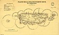
Culebrita Lighthouse (Spanish: Faro Culebrita) is the only remaining Spanish-era structure in the Culebra archipelago. Construction of the lighthouse began on September 25, 1882, and was completed on February 25, 1886. The Spanish Crown built the lighthouse to help secure its claim over the main island of Culebra. It is the most eastern light outside mainland Puerto Rico. It guided navigation through the Virgin Passage and the Vieques Sound connecting in the Puerto Rico Light System with the Cape San Juan Light.

Contents

It is located on Culebrita, a mile-long, half-a-mile-wide key off Culebra, an island-municipality of Puerto Rico. [2]

It was one of the oldest operating lighthouses in the Caribbean until 1975 when the U.S. Navy and Coast Guard closed the facility. The United States Coast Guard has replaced the lighthouse with a solar powered light beacon.

The Culebrita Lighthouse was registered on the U.S. National Register of Historic Places on October 22, 1981; however, no work has been done to maintain the facility. In 1989, Hurricane Hugo caused extensive damage, and in 1995 the tower was destroyed by Hurricane Marilyn. The Culebra Foundation, starting in 1994, has tried to attract local and federal attention to save the lighthouse, but they have had little success. The lighthouse is in danger of collapsing. [3]

See also

Related Research Articles

Culebra, Puerto Rico Island-town and municipality in Puerto Rico

Isla Culebra is an island, town and municipality of Puerto Rico and geographically part of the Spanish Virgin Islands. It is located approximately 17 miles (27 km) east of the Puerto Rican mainland, 12 miles (19 km) west of St. Thomas and 9 miles (14 km) north of Vieques. Culebra is spread over 5 barrios and Culebra Pueblo (Dewey), the main town and the administrative center of the island. Residents of the island are known as culebrenses. With a population of 1,792 as of the 2020 Census, it is Puerto Rico's least populous municipality.

Isla de Mona Island of Puerto Rico

Mona is the third-largest island of the Puerto Rican archipelago, after the main island of Puerto Rico and Vieques. It is the largest of three islands in the Mona Passage, a strait between the Dominican Republic and Puerto Rico, the others being Monito Island and Desecheo Island. It measures about 7 miles by 4 miles, and lies 41 mi (66 km) west of Puerto Rico, of which it is administratively a part. It is one of two islands that make up the Isla de Mona e Islote Monito barrio in the municipality of Mayagüez.

Cabo Rojo, Puerto Rico City and municipality in Puerto Rico

Cabo Rojo is a city and municipality situated on the southwest coast of Puerto Rico and forms part of the San Germán–Cabo Rojo metropolitan area as well as the larger Mayagüez–San Germán–Cabo Rojo Combined Statistical Area.

Culebrita Uninhabited island of Puerto Rico

Isla Culebrita is a small, uninhabited island off the eastern coast of Culebra, Puerto Rico and is part of the Puerto Rico Archipielago. Together with Cayo Botella off the northwestern point, and Pelá and Pelaita to the west, it belongs to the barrio Fraile of Culebra. It is a nature reserve and is part of the Culebra National Wildlife Refuge. The island is home to Culebrita Lighthouse, one of the oldest lighthouses in the Caribbean. Culebrita is only accessible by private boat from the main island of Culebra.

Castillo San Felipe del Morro Lighthouse First lighthouse built in Puerto Rico

Castillo San Felipe del Morro Lighthouse, also known as Faro de Morro Port San Juan Light by the National Register of Historic Places and colloquially Faro del Castillo del Morro and Puerto San Juan Light, is a lighthouse atop the walls of Castillo San Felipe del Morro in Old San Juan. It's the first lighthouse built in Puerto Rico.

Cape San Juan Light Lighthouse in Fajardo, Puerto Rico

Cape San Juan Light is a historic lighthouse located on the northeastern part of the highest point of Cape San Juan in Fajardo, Puerto Rico. The lighthouse was constructed in 1880 and was officially lit on May 2, 1882. The original illuminating apparatus, not changed until after 1898, had an 18-mile (29 km) range and displayed a fixed white light which every three minutes flashed red.

Arecibo Light Lighthouse in Arecibo, Puerto Rico

Arecibo Light is a historic lighthouse located in the city of Arecibo, Puerto Rico. It is also known as Los Morrillos Lighthouse because of its location on top of a rocky headland known as Punta Morrillos. The lighthouse was constructed and was lit in 1898. This was the last lighthouse built by the Spanish government on the island.

Punta Higuero Light Historic lighthouse in Rincón, Puerto Rico

Punta Higuero Light, also known as Faro de Punta Higuero, is an historic lighthouse located in Rincón, Puerto Rico. The original building was built in 1892 by the Spanish government and was rebuilt in 1922 by the United States Coast Guard.

Punta de las Figuras Light Lighthouse in Arroyo, Puerto Rico

Punta de las Figuras Light is an historic lighthouse located in Arroyo, Puerto Rico. It was first lit by the Spanish government in 1893. The light was relocated in 1938, and the structure was deactivated and abandoned. During World War II, the lighthouse was used as a lookout. After the U.S. Army abandoned the structure in 1963, the lighthouse was repeatedly vandalized. In 1969 the lens and lantern were destroyed. The lighthouse was again damaged by Hurricane Maria on September 20, 2017. The light housing is broken, all of the windows are boarded up, and several of the surrounding light pole fixtures are downed. The interior is currently inaccessible.

Cardona Island Light Lighthouse on Cardona Island, near Ponce, Puerto Rico

Cardona Island Light is the only 6th order lighthouse in Puerto Rico with a cylindrical attached tower. The light is located on Cardona Island, a small island on the west side of the entrance to the harbor of Ponce, Puerto Rico. It was listed in the U.S. National Register of Historic Places on 22 October 1981.

Punta Tuna Light Historic lighthouse in Maunabo, Puerto Rico

Punta Tuna Light is a historic lighthouse located in the southeast of the town of Maunabo, Puerto Rico on a narrow promontory at the southeasternmost point of the island. It was first lit in 1892 and automated in 1989. The light was a third-order lighthouse that served as the primary light connecting the island's southern and eastern lights system. The design was drawn and laid out by Joaquin Gisbert in 1890. The lighthouse construction was initially overseen by Adrian Duffaut. It was built from March 13, 1891, to September 29, 1893. Final construction was taken over by the Spanish Body of Engineers according to annotations of the historian Carlos Moral. It was originally named Faro de Mala Pascua after the cape to the west. Later, it was moved and renamed after the Point of the construction site so the light could perform a double duty warning ships off the Sargent reef. On August 8, 1899, the lighthouse suffered damage from Hurricane San Ciriaco; the town suffered heavy damage. On April 12, 1900, an act of Congress extended the jurisdiction of the Lighthouse Service to the noncontiguous territory of Puerto Rico and adjacent American waters. 1900 The Lighthouse Board took charge of the Puerto Rico lighthouses. September 13, 1928, Devastating Hurricane San Felipe II strikes, again the lighthouse stands firm, but the town housing is nearly totally destroyed. It was once again damaged by Hurricane Maria on Sept 20, 2017. The light's housing, the external facade, and the surrounding vegetation were all damaged, with some trees completely downed. It was listed in the U.S. National Register of Historic Places in 1981. In 2007, the government of Puerto Rico bought an area near the lighthouse to create a conservation area. The structure is being restored by the town of Maunabo and is open to the public. The light is not working and the lens appears to be missing. The lighthouse in a state of disrepair and locked, but one may still view it from the surrounding property.

Punta Mulas Light Lighthouse in Vieques, Puerto Rico

Punta Mulas Light, also known as Faro de Vieques, is a historic lighthouse located in the north shore of Vieques, an island-municipality of Puerto Rico. It was first lit in 1896 and automated in 1949. Punta Mulas Light was the second lighthouse built on Vieques after the Puerto Ferro Light. The light was established to guide through the dangerous passage formed by a chain of reefs. It was of key importance for navigation in the San Juan Passage.

Mona Island Light Lighthouse on the island of Mona, Puerto Rico

Mona Island Light, also known as Faro de la Isla de la Mona, is a historic lighthouse located on the island of Mona, Puerto Rico, in the Mona Passage between Puerto Rico and the Dominican Republic. It is the only lighthouse built of iron and steel in Puerto Rico. While some sources reported that the structure was designed by Gustav Eiffel, who also designed the Eiffel Tower in Paris, recent studies have shown that the tower was designed around 1885 by Spanish engineer Rafael Ravena.

Caja de Muertos Light 1887 lighthouse in Ponce, Puerto Rico

Caja de Muertos Light, is an 1887 lighthouse in Ponce, Puerto Rico, that is unique amongst all other lighthouses in Puerto Rico for its unusual Cross of Lorraine, double-arm, T-type shape structure. The historic lighthouse is located in Caja de Muertos, an uninhabited island off the coast of Ponce, Puerto Rico. The light stands at the highest point of the island.

Guánica Light Lighthouse at Guánica, Puerto Rico

Guánica Light was a historic lighthouse located in the town of Guánica, Puerto Rico in the Guánica State Forest. It was first lit in 1893 and deactivated in 1950. The light marked the entrance to Guánica Bay and bridge the gap between Los Morrillos Light and Caja de Muertos Light.

Punta Borinquen Light Lighthouse in Aguadilla, Puerto Rico

Punta Borinquen Light is a lighthouse located in the old Ramey Air Force Base in Aguadilla, Puerto Rico. The station was established in 1889 by the Spanish government. With the opening of the Panama Canal in 1914, the lighthouse would become "the most important aid to navigation on the route from Europe to Panama". In 1917, the U.S Congress provided funding for a new lighthouse in higher ground.

Puerto Ferro Light Lighthouse in Vieques, Puerto Rico

Puerto Ferro Light, also known as Faro de Puerto Ferro, is a historic lighthouse located in the Vieques, Puerto Rico. The light was first lit in 1896. It is one of the last minor or local lights to be built by the Spanish government. The light was of crucial importance to cross the Vieques Passage. The lighthouse was deactivated in 1926 when it was abandoned.

Cabras Island Light Lighthouse near Ceiba, Puerto Rico

Isla Cabras Light, also known as Faro de Isla Cabras, was a lighthouse located on a rocky but flat islet with the same name, which sit just off the coast near Ceiba, Puerto Rico, toward the Vieques Passage.

Mona Island Tramway Historic railway on Mona Island, part of the municipality of Mayaguez in Puerto Rico

The Mona Island Tramway was a 1.8 kilometres (1.1 mi) long narrow-gauge industrial railway with a gauge of 600 mm on Mona Island, part of the municipality of Mayaguez, Puerto Rico. It was laid in the 1890s to transport building materials from the beach to the construction site of the 16 meter high Mona Island Lighthouse, which was put into operation on 30 April 1900.

References

  1. "National Register Information System". National Register of Historic Places . National Park Service. July 9, 2010.
  2. Puerto Rico. Office of Historian (1949). Tesauro de datos historicos: indice compendioso de la literatura histórica de Puerto Rico, incluyendo algunos datos inéditos, periodísticos y cartográficos (in Spanish). Impr. del Gobierno de Puerto Rico. p. 302. Retrieved 4 January 2020.
  3. "A punto de colapsar el Faro Culebrita" (in Spanish). Primera Hora. 2007. Archived from the original on March 17, 2007. Retrieved 2009-04-05.