
Fajardo is a town and a municipality part of the San Juan-Caguas-Fajardo Combined Statistical Area in Puerto Rico.
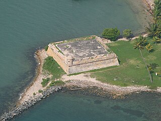
Fortín San Juan de la Cruz, most commonly known as El Cañuelo, was built on Isla de Cabras in the Palo Seco barrio of the municipality of Toa Baja, at the western end of the entrance to San Juan Bay, in Puerto Rico. The square coastal fort has massive sandstone walls that date back to the 1630s. Although the U.S. Navy bombarded the fort in 1898, the fort survived. Today the fort is part of the San Juan National Historic Site, which is listed as a UNESCO World Heritage Site and on both the National Register of Historic Places and the Puerto Rico Register of Historic Sites and Zones. The fort is not open to visitors, but it can be viewed from its exterior.
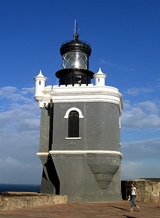
Faro del Castillo San Felipe del Morro, also known as Puerto San Juan Light, and most commonly referred to as Faro del Morro(El Morro Lighthouse), is a lighthouse atop the walls of Castillo San Felipe del Morro in Old San Juan. It's the first lighthouse built in Puerto Rico.
The Conservation Trust of Puerto Rico is a private, nonprofit organization protecting natural areas; constituting conservation easements; restoring, rehabilitating and preserving historical structures; developing educational programs that foster the protection of natural areas; and directing a tree nursery program for native and endemic species, among others. The Conservation Trust of Puerto Rico has been accredited by The Land Trust Accreditation Commission. The Conservation Trust is also a member of the International Union for Conservation of Nature, a global environmental organization with more than 1,200 public and private members from 160 countries.

Punta de las Figuras Light is an historic lighthouse located in Arroyo, Puerto Rico. It was first lit by the Spanish government in 1893. The light was relocated in 1938, and the structure was deactivated and abandoned. During World War II, the lighthouse was used as a lookout. After the U.S. Army abandoned the structure in 1963, the lighthouse was repeatedly vandalized. In 1969 the lens and lantern were destroyed. The lighthouse was again damaged by Hurricane Maria on September 20, 2017. The light housing is broken, all of the windows are boarded up, and several of the surrounding light pole fixtures are downed. The interior is currently inaccessible.

Cardona Island Light is the only 6th order lighthouse in Puerto Rico with a cylindrical attached tower. The light is located on Cardona Island, a small island on the west side of the entrance to the harbor of Ponce, Puerto Rico. It was listed in the U.S. National Register of Historic Places on 22 October 1981 and on the Puerto Rico Register of Historic Sites and Zones in 2001.

Punta Tuna Light is a historic lighthouse located in the southeast of the town of Maunabo, Puerto Rico on a narrow promontory at the southeasternmost point of the island.

Punta Mulas Light, also known as Faro de Vieques, is a historic lighthouse located in the north shore of Vieques, an island-municipality of Puerto Rico. It was first lit in 1896 and automated in 1949. Punta Mulas Light was the second lighthouse built on Vieques after the Puerto Ferro Light. The light was established to guide through the dangerous passage formed by a chain of reefs. It was of key importance for navigation in the San Juan Passage.

Guánica Light was a historic lighthouse located in the municipality of Guánica, Puerto Rico in the Guánica State Forest. It was first lit in 1893 and deactivated in 1950. The light marked the entrance to Guánica Bay and bridge the gap between Los Morrillos Light and Caja de Muertos Light.

The Iglesia de San Juan Bautista in Maricao, Puerto Rico is a church built during 1890-c.1898. It was listed on the National Register of Historic Places in 1984, and on the Puerto Rico Register of Historic Sites and Zones in 2000.

Isla Cabras Light, also known as Faro de Isla Cabras, was a lighthouse located on a rocky but flat islet with the same name, which sit just off the coast near Ceiba, Puerto Rico, toward the Vieques Passage.
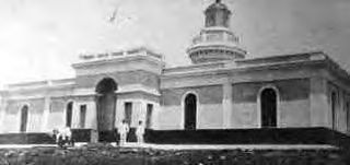
The Battle of Fajardo was an engagement between the armed forces of the United States and Spain that occurred on the night of August 8–9, 1898 near the end of the Puerto Rican Campaign during the Spanish–American War.
Beatriz Del Cueto López-Hidalgo is a Cuban-born architect specialising in conservation and architectural preservation. A resident of Puerto Rico since 1960, del Cueto is a Fellow of the American Academy in Rome, Fellow of the American Institute of Architects, and Henry Klumb Award winner in 2012.
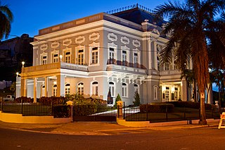
The Antiguo Casino de Puerto Rico, located at Avenida Ponce de León 1 in San Juan, Puerto Rico, is a Beaux Arts architecture style building dating from 1917. It was listed on the National Register of Historic Places in 1977, and on the Puerto Rico Register of Historic Sites and Zones in 2000.

Culebrita Lighthouse is the only remaining Spanish-era structure in the Culebra archipelago. Construction of the lighthouse began on September 25, 1882, and was completed on February 25, 1886. The Spanish Crown built the lighthouse to help secure its claim over the main island of Culebra. It is the most eastern light outside mainland Puerto Rico. It guided navigation through the Virgin Passage and the Vieques Sound connecting in the Puerto Rico Light System with the Cape San Juan Light.

The Polvorín de Miraflores is an 18th-century structure in San Juan, Puerto Rico, specifically in the Isla Grande sector of Santurce, that served as an ammunition storage place for the Spanish military. The site was included in the National Register of Historic Places in 1984 and on the Puerto Rico Register of Historic Sites and Zones in 2000 for its historic importance.

The General Norzagaray Bridge is a brick and masonry barrel vault bridge built in 1855 in San Juan, Puerto Rico. Also known as Puente de los Frailes, it brings what is now Puerto Rico Highway 873 across Frailes Creek, a tributary to the Guaynabo River. It has eight 9.8-metre (32 ft) barrel vault spans. Its total length is 120.7 metres (396 ft) and its roadway width is 7.00 metres (22.97 ft). It was listed on the National Register of Historic Places (NRHP) in 1995, and on the Puerto Rico Register of Historic Sites and Zones in 2000.

The Gautier Benitez High School, a school named after Puerto Rican poet José Gautier Benítez, was built in 1924 in Caguas, Puerto Rico and is listed on both the U.S. National Register of Historic Places and the Puerto Rico Register of Historic Sites and Zones.
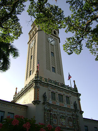
Roosevelt Tower, more popularly known as La Torre, is a 173.54 feet clock tower located above the main entrance to the Baldorioty de Castro Building in the University of Puerto Rico, Río Piedras Campus. The tower is also referred to as El Faro and it is considered a symbol of the University of Puerto Rico and of higher education in Puerto Rico. The tower, along with the main historic quadrangle in campus, have been listed on the National Register of Historic Places since 1984, and on the Puerto Rico Register of Historic Sites and Zones since 2000.


