
The University of Puerto Rico is the main public university system in the U.S. Commonwealth of Puerto Rico. It is a government-owned corporation with 11 campuses and approximately 58,000 students and 5,300 faculty members. UPR has the largest and most diverse academic offerings in the commonwealth, with 472 academic programs of which 32 lead to a doctorate.
Jayuya is a town and municipality of Puerto Rico located in the mountainous center region of the island, north of Ponce; east of Utuado; and west of Ciales. Jayuya is spread over 10 barrios and Jayuya Pueblo. It is the principal city of the Jayuya Micropolitan Statistical Area.

Manatí is a city and municipality of Puerto Rico on the northern coast, north of Morovis and Ciales; east of Florida and Barceloneta; and west of Vega Baja. Manatí is spread over 8 barrios and Manatí barrio-pueblo. It is part of the San Juan-Caguas-Guaynabo Metropolitan Statistical Area.

The University of Puerto Rico, Río Piedras Campus is a public land-grant research university in San Juan, Puerto Rico. It is the largest campus in the University of Puerto Rico system in terms of student population and it was Puerto Rico's first public university campus.

Río Piedras is a populous district of San Juan, and former town and municipality of Puerto Rico, which was merged with the municipality of San Juan in 1951. The district today is composed of various barrios such as Pueblo and Universidad. The historic town was founded in 1714 as El Roble, it was given municipality rights in 1823, and since 1903 it has been the home of the University of Puerto Rico's main campus, earning the popular name of Ciudad Universitaria today. The downtown and historic center of Río Piedras is officially known as the Pueblo barrio of the municipality of San Juan.

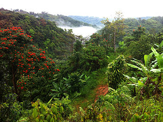
Toro Negro State Forest is one of the 21 forests that make up the public forests system in Puerto Rico. It is also Puerto Rico's highest cloud forest. It is in the Cordillera Central region of the island and covers 8,204 cuerdas, of mountains. Toro Negro's mountains have heights reaching up to 4,400 feet (1,300 m) and include Cerro de Punta, Cerro Jayuya and Cerro Rosa, the three highest peaks in the island. Nested among these mountains is Lake Guineo, the island's highest lake. The forest has 18 kilometers (11 mi) of trails, an observation tower, two natural swimming pools (Spanish:"charcos"), camping and picnic areas, nine rivers, and numerous creeks and waterfalls. The forest spans areas within the municipalities of Ponce, Jayuya, Orocovis, Ciales, and Juana Díaz, and consists of seven non-contiguous tracts of land. The largest contiguous segment of the forest is located in the municipalities of Ponce and Jayuya. Some 40% of the area of Toro Negro State Forest is located in Ponce's Barrio Anón.
The Caricaboa River is a river of Jayuya, Puerto Rico.

The Gurabo River is a river and tributary of the Loíza River in Puerto Rico. In 2018, the U.S. Army Corps of Engineers announced work would be done on the river, which runs through several municipalities including Gurabo, Juncos, and Las Piedras.
The Piedras River is a river of Puerto Rico in the municipality of Utuado. This is one of many rivers with this name in Puerto Rico.
The Valenciano River is a river in eastern Puerto Rico which flows through the municipalities of Juncos and Las Piedras, Puerto Rico. After Juncos, the river reaches a confluence on the left bank of the Río Gurabo, which is itself a tributary of the Río Grande de Loíza which flows north into the Atlantic Ocean. Since Hurricane Maria in September 217, the data on river drainage has not been updated.
The University High School, commonly referred to by its initials "UHS", in San Juan, Puerto Rico is a college preparatory laboratory high school operated by the Faculty of Education of the University of Puerto Rico. Located on the University of Puerto Rico, Río Piedras Campus, it provides education to approximately 514 students from 7th to 12th grade.
The 2010–2011 University of Puerto Rico strikes (UPR) refer to the student strikes which took place between May 2010 and June 2010 in ten of the university system's eleven constituent institutions, as well as the protests that occurred from October 2010 to February 2011.
Loverbar was a queer bar, restaurant and nightclub located in Río Piedras, San Juan, Puerto Rico. As a queer club it was the first of its kind in Puerto Rico, with Refinery29 calling it "the queer destination for everything exciting, progressive, and radical about the Puerto Rican queer scene." It opened in 2020 and announced its closure at the end of 2021.
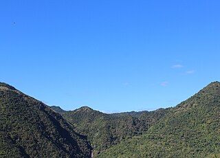
The Planadas-Yeyesa Nature Reserve is a protected nature reserve located in the Sierra de Cayey, in the municipality of Salinas in central Puerto Rico. The reserve is located close to the famous Cerro Las Tetas. Two of the most prominent features of the reserve are Cerro Planada, a 2,480 feet high mountain peak, and La Yeyesa, a heavily forested canyon formed by the Lapa River and other streams which feed into the Nigua River. La Yeyesa can be accessed through a lightly trafficked yet moderate trail.
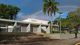
The Museum of History, Anthropology and Art of the University of Puerto Rico — often shortened to Museum of the UPR or MAHA — is a university museum dedicated to anthropology, archaeology and the history of art of Puerto Rico located on the grounds of the University of Puerto Rico, Río Piedras Campus. Officially dating to 1951, this museum is the oldest in Puerto Rico with its first collection being even older dating to 1914, donated by then Resident Commissioner Federico Degetau.
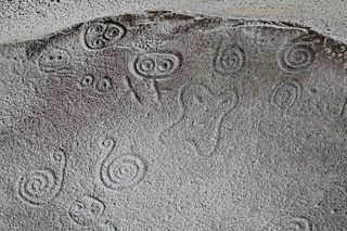
La Piedra Escrita is a rock art site consisting of a large granite boulder containing pictographs located in the Saliente River in Coabey, Jayuya in central Puerto Rico. The petroglyphs have become popularly associated with the Taino people and have been widely reproduced in popular art, and the site has become a popular tourist attraction. The site was added to the United States National Register of Historic Places in 2003 due to its importance as a prime example of prehistoric rock art in Puerto Rico.
