
The Dominican Republic is a country in the West Indies that occupies the eastern five-eighths of Hispaniola. It has an area of 48,670 km2, including offshore islands. The land border shared with Haiti, which occupies the western three-eighths of the island, is 376 km long. The maximum length, east to west, is 390 km from Punta de Agua to Las Lajas, on the border with Haiti. The maximum width, north to south, is 265 km from Cape Isabela to Cape Beata. The capital, Santo Domingo, is located on the south coast.

The Arctic Archipelago, also known as the Canadian Arctic Archipelago, is an archipelago lying to the north of the Canadian continental mainland, excluding Greenland and Iceland

This is a list of the extreme points of North America: the points that are highest and lowest, and farther north, south, east or west than any other location on the continent. Some of these points are debatable, given the varying definitions of North America.

Pedernales is the southernmost province of the Dominican Republic, including the offshore island of Isla Beata. It was split from Barahona in 1957. Of its 2,074.53 km2, 1,374 km2 belongs to the Jaragua National Park. A third of its population is of Haitian origin, the highest ratio within the country.
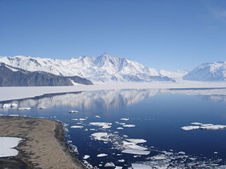
The Admiralty Mountains is a large group of high mountains and individually named ranges and ridges in northeastern Victoria Land, Antarctica. This mountain group is bounded by the sea, and by the Dennistoun Glacier, Ebbe Glacier, and Tucker Glacier.

The Dennistoun Glacier is a glacier, 50 nautical miles long, draining the northern slopes of Mount Black Prince, Mount Royalist and Mount Adam in the Admiralty Mountains of Victoria Land, Antarctica. It flows northwest between the Lyttelton Range and Dunedin Range, turning east on rounding the latter range to enter the sea south of Cape Scott.
This is a list of the extreme points of The Americas, the points that are farther north, south, east or west than any other location on the continent. The continent's southernmost point is often said to be Cape Horn, which is the southernmost point of the Chilean islands. The Americas cross 134° of longitude east to west and 124° of latitude north to south.

The Mexican Riviera refers collectively to twenty cities and lagoons lying on the western coast of Mexico. Although there are long distances between these cities, they are often collectively referred to as the Mexican Riviera because of their many oceanfront resorts and their popularity among tourists. Cruise ships often visit three or four of these destinations on their longer cruises. In a 2005 interview Stanley McDonald, the founder of Princess Cruises, mentioned:
The call of the "Mexican Riviera" was coined by Princess Cruise Line. Now everyone refers to it as the Mexican Riviera. I believe that it really spoke to the quality and beauty of what people would see down there. We all know the French Riviera -- the Mexican Riviera was something we had in the western hemisphere.
Quam Heights is a mostly snow-covered heights, 15 nautical miles long and 4 nautical miles wide, rising over 1,000 metres (3,300 ft) and forming the coastline between the Barnett Glacier and Dennistoun Glacier in northern Victoria Land, Antarctica.
SS Pedernales was a lake tanker of the World War II and post war eras. She was built in 1938 in Monfalcone, Italy, and sailed under the British flag. Pedernales was severely damaged in a torpedo attack on 16 February 1942 while anchored at Aruba.
Cabo Beata is the southernmost point of the island of Hispaniola, in the Pedernales Province of the Dominican Republic. The small island of Isla Beata stands about 4 mi southwest of the cape.

Villagonzalo Pedernales is a municipality located in the province of Burgos, Castile and León, Spain. According to the 2004 census (INE), the municipality has a population of 1,043 inhabitants.

The Wilkie Sugarloaf Trail is a hiking trail in northern Cape Breton Island in the Canadian province of Nova Scotia. The trail leads to the 411.8 metres (1,351 ft) summit of Wilkie Sugar Loaf in the Cape Breton Highlands.

The Adare Peninsula, is a high ice-covered peninsula, 40 nautical miles long, in the northeast part of Victoria Land, extending south from Cape Adare to Cape Roget. The peninsula was named by the New Zealand Antarctic Place-Names Committee (NZ-APC) for Cape Adare. The peninsula is considered the southernmost point of the Borchgrevink Coast, named for Carsten Borchgrevink (1864-1934).

Kouka is a department or commune of Banwa Province in western Burkina Faso. Its capital is the town of Kouka. According to the 2019 census the department has a total population of 73,747.
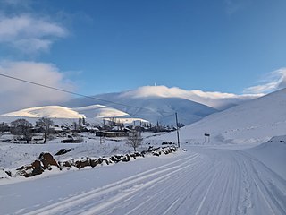
Hovtashen is a village in the Artik Municipality of the Shirak Province of Armenia.
Sisavan is a village in the Vedi Municipality of the Ararat Province of Armenia.
Gramada is a town in northwestern Bulgaria, part of Vidin Province. It is the administrative centre of the homonymous Gramada Municipality, which lies in the central part of Vidin Province. It is located in the western Danubian Plain, 30 kilometres (19 mi) from the provincial capital Vidin and 200 kilometres (120 mi) from Sofia. As of December 2009, the town had a population of 1,647.

The Dominican city of Pedernales is the capital of the Pedernales Province, in the Dominican Republic. It is located in the southwest of the country, on the Dominican Republic–Haiti border, and has a crossing to the Haitian town of Anse-à-Pitres.
Pepillo Salcedo is a municipality in the Monte Cristi Province of the Dominican Republic, located next to the border with Haiti. Pepillo Salcedo is frequently named Manzanillo due to the bay of manzanillo Bahia De Manzanillo which is approximately 2 miles from playa el coquito coquito beach. the city received its name from José Antonio Salcedo Ramírez who was a combatant in the long war days of the consolidation of national independence day in the Dominican Republic. General Salcedo Ramírez was also an outstanding military leader in the intense restorative war from 1863 to 1865. Pepillo Salcedo is a coastal town. It is built on the shores of the Bay of Manzanillo. In the westernmost part of the Dominican Northwest.
