Interstate 590 (I-590) is a north–south auxiliary Interstate Highway that serves the immediate southeastern suburbs of the city of Rochester, New York, in the United States. It extends for 5.07 miles (8.16 km) from an interchange with I-390 in Brighton to the Can of Worms, a complex interchange connecting I-590 to I-490 just inside the Rochester city line. I-590 makes up the southeast quadrant of the Rochester Outer Loop, which continues west on I-390 and north past the Can of Worms on New York State Route 590 (NY 590). The highway is a spur route of I-90; the connection between the two is made via both I-390 and I-490.
North Carolina Highway 295 (NC 295), also known as the Fayetteville Outer Loop, is a partially completed Interstate-grade planned 34-mile (55 km) bypass around the western side of Fayetteville, North Carolina. When completed or approved, it will become Interstate 295 (I-295).

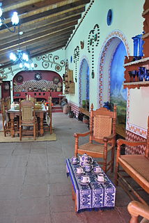
Lerma is a city and municipality located just east of Toluca and 54 km west of Mexico City in State of Mexico, Mexico. The city was founded in the early colonial period and named after the Duke of Lerma in Spain. The municipal area saw two battles of the Mexican War of Independence, the Battle of Monte de las Cruces and the Battle of Lerma. For a time after independence, the city was the capital of Mexico State before it was moved to Toluca. The municipality is in one of the most densely populated areas of Mexico and is growing. Much of this growth is occurring near the Toluca-Mexico City highway and on the floodplains of the Lerma River. The latter has caused significant problems with flooding when the river overflows its banks during the rainy season. The Nahuatl name for the area is Cacamilhuacan, which translates to “crows in the field.” In the early colonial period, the area was called Santa Clara Cacamilhuacan. The municipality has both an Aztec glyph with a crow reflecting its Nahuatl name and a Spanish coat of arms.

Federal Highway 119 is a Federal Highway of Mexico. Federal Highway 119 is split into two segments: the first segment travels from Tejocotal, Hidalgo in the north to Apizaco, Tlaxcala in the south. The second segment travels from Tlaxcala City in the north to Puebla City in the south.

Federal Highway 136 is a Federal Highway of Mexico. The highway travels from Zacatepec, Puebla in the east to Los Reyes Acaquilpan, State of Mexico in the west.
Federal Highway 190 is a Federal Highway of Mexico. Federal Highway 190 is split into two segments: the first segment travels from Tehuantepec, Oaxaca in the east to Puebla City, Puebla in the west. The second segment travels from La Ventosa, Juchitán de Zaragoza Municipality, Oaxaca in the west eastward to Ciudad Cuauhtémoc, Chiapas. Fed. Highway 190's eastern segment ends at a Guatemala-Mexico border crossing at Ciudad Cuauhtémoc. The Pan-American Highway route in southern Mexico continues into Guatemala as Central American Highway 1 (CA-1).

Mexican handcrafted fireworks production is mostly concentrated in the State of Mexico in central Mexico. The self-declared fireworks capital of Mexico is Tultepec, just north of Mexico City. Although the main ingredient for fireworks, gunpowder, was brought by the conquistadors in the 16th century, fireworks became popular in Mexico in the 19th century. Today, it is Latin America’s second largest producer, almost entirely for domestic use, with products ranging from small firecrackers to large shells and frames for pyrotechnics called “castillos” (castles) and “toritos”. The industry is artisanal, with production concentrated in family-owned workshops and small factories with a number operating illegally. The relatively informal production and sales of fireworks have made it dangerous with a number of notable accidents in from the late 1990s to the present, despite attempts to safety regulations.
On 7 May 2013, a tanker truck carrying liquefied petroleum gas lost control and ran into several cars and houses before it exploded on Federal Highway 85 in San Pedro Xalostoc community in Ecatepec de Morelos, Mexico. 27 people were killed and more than 30 injured as a result of the accident. The resulting fires damaged 45 homes and 16 vehicles.
The Autopista Chamapa–La Venta is a toll road in Greater Mexico City. It, together with the Autopista Chamapa-Lechería is a single through route serving as a partial ring road (beltway) on the west side of the megalopolis. It connects:
The Arco Norte, designated and signed as Federal Highway M40D, is a toll road in Mexico. It serves as a bypass around Greater Mexico City and currently links the Mexico-Puebla toll road on the east with the Mexico-Guadalajara toll road on the west.
Veterans Outer Loop is a major bypass route in Glasgow, Kentucky. It is maintained by the Kentucky Transportation Cabinet (KYTC).
The State of Mexico produces various kinds of handcrafted items. While not as well documented as the work of other states, it does produce a number of notable items from the pottery of Metepec, the silverwork of the Mazahua people and various textiles including handwoven serapes and rebozos and knotted rugs. There are seventeen recognized handcraft traditions in the state, and include both those with pre Hispanic origins to those brought over by the Spanish after the Conquest. As the state industrializes and competition from cheaper goods increases, handcraft production has diminished. However, there are a number of efforts by state agencies to promote these traditions both inside and outside of Mexico.

XHLUV-FM is a community radio station in Luvianos, State of Mexico. Broadcasting on 96.5 FM, XHLUV is owned by La Calentana Luvimex, A.C.

On 20 December 2016, a fireworks explosion occurred at the San Pablito Market in the city of Tultepec, north of Mexico City. At least 42 people were killed, and dozens injured.

Federal Highway 117D is the designation for two toll highways in eastern Mexico.
Federal Highway 150D is a toll highway connecting Mexico City to Veracruz City via Puebla City and Córdoba. It serves as one of the backbones of Mexico's toll road system. The road is primarily operated by Caminos y Puentes Federales, which charges cars 520 pesos to travel Highway 150D, with one segment in the Puebla metropolitan area built and maintained by OHL and PINFRA.
Federal Highway 57D (Fed. 57D) is a tolled (cuota) part of the federal highways corridor of the paralleling Fed. 57. Eight separate tolled segments exist of Fed. 57D between Mexico City and Allende, Coahuila; a ninth is part-federal and part-state.


