
Campeche is a state on the Yucatán Peninsula in Mexico that is divided into thirteen municipalities. According to the 2020 Mexican Census, Campeche is the third least populous state with 928,363 inhabitants and the 17th largest by land area spanning 57,693.59 square kilometres (22,275.62 sq mi).

Chiapas is a state in Southwest Mexico. According to the 2020 Mexican Census, it has the eighth largest population of all states with 5,543,828 inhabitants and the 10th largest by land area spanning 73,560.47 square kilometres (28,401.86 sq mi). Chiapas is officially divided into 124 municipalities, although the establishment of municipal authorities in Belisario Domínguez was suspended in 2015 pending the resolution of a territorial dispute between Chiapas and the neighbouring state of Oaxaca. In 2021, the Mexican Supreme Court resolved this dispute in Oaxaca's favour, and annulled the 2011 decree that had created Belisario Domínguez.

Municipalities are the second-level administrative divisions of Mexico, where the first-level administrative division is the state. They should not be confused with cities or towns that may share the same name as they are distinct entities and do not share geographical boundaries. As of January 2021, there are 2,454 municipalities in Mexico, excluding the 16 boroughs of Mexico City.

Mapastepec is a town and municipality in the southeastern state of Chiapas, Mexico. Its name derives from the place name mapachtepec, "Hill of the Raccoon", a compound of the Nahuatl words mapachi ("raccoon") and tepetl ("mountain").
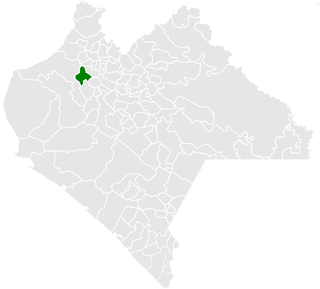
Copainalá is a town and municipality in the Mexican state of Chiapas in southern Mexico. It covers an area of 330.4 km².
Maravilla Tenejapa is a town and one of the 119 Municipalities of Chiapas, in southern Mexico.

Motozintla is a city and one of the 119 municipalities of Chiapas, in southern Mexico.
Pantepec is a town and one of the 119 municipalities of Chiapas, in southern Mexico. The Chiapas Zoque language is spoken in this municipality.

Sabanilla is a town and one of the 119 Municipalities of Chiapas, in southern Mexico.

Pueblo Nuevo Solistahuacán is a town and one of the 125 municipalities of Chiapas in southern Mexico.

Reforma is a city and one of the 119 Municipalities of Chiapas, in southern Mexico.
Cojumatlán de Régules is a municipality in the Mexican state of Michoacán, located 180 kilometres (110 mi) west of the state capital of Morelia.

Seybaplaya is a municipality in the Mexican state of Campeche, located 27 kilometres (17 mi) southwest of the state capital of Campeche City. Its creation was approved in 2019 and came into force on 1 January 2021.

Dzitbalché is a municipality in the Mexican state of Campeche, located 73 kilometres (45 mi) northeast of the state capital of Campeche City. Its creation from the municipality of Calkiní was approved in 2019 and went into force on 1 January 2021.
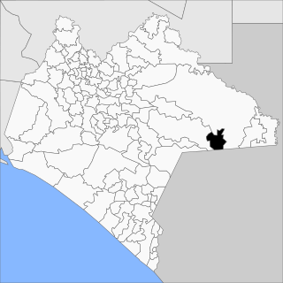
Honduras de la Sierra is a municipality in the Mexican state of Chiapas, located approximately 150 kilometres (93 mi) southeast of the state capital of Tuxtla Gutiérrez. Gazetted in 2019, it is the newest municipality in Chiapas.
Capitán Luis Ángel Vidal is a municipality in the Mexican state of Chiapas, located approximately 138 kilometres (86 mi) southeast of the state capital of Tuxtla Gutiérrez. Its inhabitants are of Guatemalan origin and speak the Mam language.
Rincón Chamula San Pedro is a municipality in the Mexican state of Chiapas, located approximately 54 kilometres (34 mi) north of the state capital of Tuxtla Gutiérrez. Unlike the mestizo population of the surrounding towns, its population is mostly indigenous Tzotzil.
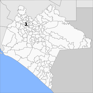
Mezcalapa is a municipality in the Mexican state of Chiapas, located approximately 71 kilometres (44 mi) northwest of the state capital of Tuxtla Gutiérrez. Its municipal seat is Raudales Malpaso.
El Parral is a municipality in the Mexican state of Chiapas, located approximately 45 kilometres (28 mi) south of the state capital of Tuxtla Gutiérrez.
Emiliano Zapata is a municipality in the Mexican state of Chiapas, located approximately 33 kilometres (21 mi) southeast of the state capital of Tuxtla Gutiérrez.


