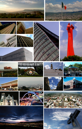
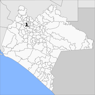
Tuxtla Gutiérrez, or Tuxtla,(Spanish: [ˈtuɣstla ɣuˈtjeres], Nahuatl: [ˈtuʃt͡ɬa]) is the capital and the largest city of the Mexican southeastern state of Chiapas. It is the seat of the municipality of the same name, the most developed and populated in the state. A busy government, commercial and services-oriented city, Tuxtla had one of the fastest-growing rates in Mexico in the last 40 years. Unlike many other areas in Chiapas, it is not a major tourist attraction, but a transportation hub for tourists coming into the state, with a large airport and a bus terminal.

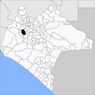
Ocozocoautla de Espinosa, colloquially Coita, is a town and municipality in the Mexican state of Chiapas. It is located in the western part of the state, 24 km west of Tuxtla Gutierrez covering parts of the Depresión Central and the Montañas del Norte. It is bordered to the north by Tecpatán, to the east by Berriozábal, Tuxtla Gutiérrez and Suchiapa, to the south by Villaflores and to the west by Jiquipilas and Cintalapa. The name comes from the Nahua language and means ‘forest of ocozote trees’. ‘De Espinosa’ was added in 1928 to honor Raymundo Enríquez Espinosa who was the first governor of the state of Chiapas. Ocozocoautla gained city status in 1926. The climate is warm and humid and the vegetation is mostly high and medium rainforest.

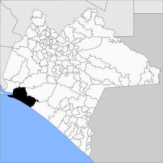
Villaflores Municipality is a municipio (municipality) in the state of Chiapas, southern Mexico, and the name of its largest settlement and seat of the municipal government. Situated in the Sierra Madre de Chiapas range, the municipality has an area of approximately 1232 km2 at an average elevation of 540m above mean sea level.

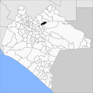
Berriozábal is a city and municipality in the Mexican state of Chiapas, in southern Mexico. It covers an area of 352 km².
Cacahoatán is a city and municipality in the Mexican state of Chiapas, in southern Mexico. It covers an area of 173.9 km².
Frontera Comalapa is a town and one of the 119 municipalities of Chiapas, in southern Mexico. It covers an area of 717.90 km².
Bochil is a city and municipality in the Mexican state of Chiapas, in southern Mexico. It covers an area of 372.7 km². Bochil serves as the head town for the Second Federal Electoral District of Chiapas.

Huixtla is a town and one of the 119 municipalities of Chiapas, in southern Mexico.

Las Rosas is a city and one of the 119 Municipalities of Chiapas, in southern Mexico.

Venustiano Carranza is a city and one of the 119 municipalities of Chiapas, in southern Mexico.

Motozintla is a city and one of the 119 municipalities of Chiapas, in southern Mexico.

Pichucalco is a town and one of the 119 municipalities of Chiapas, in southern Mexico.
Pantepec is a town and one of the 119 municipalities of Chiapas, in southern Mexico. The Chiapas Zoque language is spoken in this municipality.

Pueblo Nuevo Solistahuacán is a town and one of the 125 municipalities of Chiapas in southern Mexico.

Reforma is a city and one of the 119 Municipalities of Chiapas, in southern Mexico.
San Fernando is a town and one of the 119 Municipalities of Chiapas, in southern Mexico.

Villa Corzo is a city and one of the 119 municipalities of Chiapas, in southern Mexico. The city of Villa Corzo (the municipal seat is located at
Tonalá is one of the 119 municipalities of Chiapas, in southern Mexico.
Yajalón is a city and one of the 119 Municipalities of Chiapas, in southern Mexico.

Acala is a municipality in the Mexican state of Chiapas, in southern Mexico. The municipal seat is Acala.


