Related Research Articles

Morelos, officially the Free and Sovereign State of Morelos, is one of the 32 states which comprise the Federal Entities of Mexico. It is divided into 36 municipalities and its capital city is Cuernavaca.
Amacuzac is a city in the Mexican state of Morelos. The name means In the River of Yellow Amates. Amacuzac stands at 18°36′N99°23′W, at a mean height of 900 meters above sea level. The city serves as the municipal seat for the surrounding municipality of the same name. The municipality reported 17,772 inhabitants in the year 2015 census and covers a total surface area of 125 km². The 2020 census reported 17,598 inhabitants in the municipality and 5,575 in the city of Amacuzac.

Atlatlahucan is a city in the Mexican state of Morelos. The name means Place of red or brown water, and today the water is stored in a type of cistern called a jagüey. To the north is the State of Mexico, south is Cuautla, east is Yecapixtla, and west are Tlayacapan and Yautepec. It stands at 18°56′N98°54′W, at a mean height of 1,656 metres above sea level. The municipality covers 71 km2.
Coatlán del Río is a town in the Mexican state of Morelos. It stands at 18°45′N99°26′W, at a mean height of 1,010 metres above sea level.
Huitzilac is a city in the Mexican state of Morelos. It stands at 19°01′42″N99°16′02″W and at an altitude of 2,561 m (8,402 ft) above sea level.
Jantetelco, officially Jantetelco de Matamoros, is a city in the Mexican state of Morelos. . The city serves as the municipal seat for the surrounding municipality of the same name. The municipality reported 17,238 inhabitants in the year 2015 census.
Jiutepec is a city and its surrounding municipality in the Mexican state of Morelos.
Jojutla is a municipality in the state of Morelos, Mexico. Its municipal seat is the city of Jojutla de Juárez. The name Jojutla comes from Nahuatl Xoxōuhtlān and means, Place of abundant blue skies. Another interpretation is Jojutla should be written Xo-Xoutla and its etymological roots come from: xoxou-ki, and Tla-ntli, (teeth) to indicate abundance, so the name means: Place abundant in blue paint. This meaning is corroborated by Father José Agapito Mateo Minos in Nohualco Tlalpixtican (1722), about how he saw the maceration and decanting tanks of the xoxouki plant, when it still existed in the plaza Zacate. Ángela Peralta mentions a unique pyramid consisting of three parts: the momozok, the turret and the campanile (tower), demolished by the colonial government. Remnants of this can be seen in the staircase of the municipal palace.

Miacatlán is a city and municipal seat of the municipality of Miacatlán in the Mexican state of Morelos. It stands at 18°46′20″N99°21′17″W.

Puente de Ixtla is a city in the Mexican state of Morelos. It stands at 18°37′01″N99°19′23″W. The city serves as the municipal seat for the surrounding municipality of the same name. The municipality reported 66,435 inhabitants in the year 2015 census.

Temixco is the fourth-largest city in the Mexican state of Morelos. It stands at 18°51′N99°14′W in the west-northwest part of the state.
Temoac is a town in the Mexican state of Morelos.
Tepalcingo is a town in the Mexican state of Morelos. It at 18°26′N98°18′W. The name Nahuatl root tekpa-tl (flint), tzintli, tzinco, so in sum it means tekpatzinko "down or behind the flints".

Tetecala is a city in the Mexican state of Morelos.
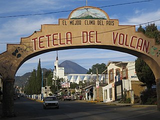
Tetela del Volcán or simply Tetela, is a town and municipal seat of the municipality of Tetela del Volcán in the Mexican state of Morelos. It is located on the slopes of the volcano Popocatépetl. 18°57′48″N99°15′12″W. The city serves as the municipal seat for the surrounding municipality of the same name. It is notable for its sixteenth century Dominican ex-convent which together with a number of other early monasteries nearby in the area has been declared a UNESCO World Heritage Site. The municipality reported 20,698 inhabitants in the year 2015 census. Other towns in the municipality of Tetela del Volcán include Hueyapan, Xochicalco and Tlamimilulpan.
Tlaltizapán de Zapata is a city in the Mexican state of Morelos. It stands at 18°4′N99°07′W.

18°37′44″N90°09′37″WTlaquiltenango is a city in the Mexican state of Morelos. It is 151.6 kilometres (94.2 mi) south of Mexico city and 60.1 kilometres (37.3 mi) southeast of Cuernavaca, the state capital via Mexican Federal Highway 95D.
Xochitepec is a municipio (municipality) of the state of Morelos, in central Mexico. Xochitepec is also the name of its principal township and seat of the municipal government. It is located approximately 13 km (8.1 mi) to the south of the capital of Morelos, Cuernavaca, on the southern outskirts of that city's greater metropolitan area.
Xoxocotla is a town located in the southern part of the state of Morelos, about 30 km south of the state capital Cuernavaca. The name comes from the Nahuatl language, Xoxo-oco-tlan: “place where there are green pines". Formerly part of Puente de Ixtla, it became its own indigenous municipality on 1 January 2019. It recorded a population of 21,074 inhabitants in the 2010 Mexican census.
Coatetelco is an autonomous indigenous municipality created on January 1, 2019 in the Mexican state of Morelos. Located 980 meters (3,215 ft.) above sea level, the municipality includes Lake Coatetelco and the Coatetelco archaeological site. It is one of the few indigenous fishing communities in central Mexico and has a population of 9,094.
References
- 1 2 Enciclopedia de los Municipios: Morelos: Mazatepec retrieved Dec 27, 2018
- ↑ http://cuentame.inegi.org.mx/monografias/informacion/mor/poblacion/default.aspx (Dec 13, 2018)
- 1 2 "Mazatepec, Morelos | Guia Turistica México". www.guiaturisticamexico.com. Retrieved Dec 27, 2018.
- 1 2 3 "Mazatepec". Enciclopedia de Los Municipios y Delegaciones de México Estado de Morelos (in Spanish). Mexico: INAFED. Retrieved March 28, 2014.
- ↑ Redacción, La. "Situación actual del coronavirus Covid-19 en Morelos" [Present situation of coronavirus COVID-19 in Morelos]. www.launion.com.mx (in European Spanish). Retrieved Apr 29, 2020.
- ↑ "Coronavirus en Morelos | Diario de Morelos". www.diariodemorelos.com (in Spanish). Retrieved June 4, 2020.
- ↑ Preciado, Tlaulli. "En Morelos, cinco mil 319 casos confirmados acumulados de covid-19 y mil 27 decesos". La Unión (in European Spanish). Retrieved September 1, 2020.
- ↑ "Llega Morelos a 1 mil 600 muertes por COVID19". diariodemorelos.com (in Spanish). Diario de Morelos. December 27, 2020. Retrieved December 28, 2020.
- 1 2 3 Guia Turistica: Municipio Mazatapec retrieved Dec 27, 2018
- ↑ "Vigrous Methods Taken". The Portal to Texas History. March 24, 1911. Retrieved March 5, 2019.
- ↑ "Candidatos electos 2018" (PDF). Instituto Morelense de Procesos Electorales y Participación Ciudadana. Retrieved Dec 14, 2018.
