
Tula is a town located in Tula Municipality in the Mexican state of Tamaulipas.
Tula is a town located in Tula Municipality in the Mexican state of Tamaulipas.
The city was founded on 22 July 1617, by the Franciscan friar Juan Baptist of Mollinedo; thus, it is usually considered the oldest city in the state of Tamaulipas.
In 2011, Tula was declared a Pueblo Mágico . In August 2013, archeologists discovered 30 skeletons estimated to be about 3,000 years old. This could mean that the area of Tula was home to one of oldest genetic lineages of America. [1]
| Climate data for Tula, Tamaulipas (1951–2010) | |||||||||||||
|---|---|---|---|---|---|---|---|---|---|---|---|---|---|
| Month | Jan | Feb | Mar | Apr | May | Jun | Jul | Aug | Sep | Oct | Nov | Dec | Year |
| Record high °C (°F) | 33.0 (91.4) | 36.0 (96.8) | 41.0 (105.8) | 45.0 (113.0) | 45.0 (113.0) | 44.0 (111.2) | 39.0 (102.2) | 39.0 (102.2) | 39.5 (103.1) | 40.0 (104.0) | 39.0 (102.2) | 39.0 (102.2) | 45.0 (113.0) |
| Average high °C (°F) | 21.9 (71.4) | 23.8 (74.8) | 27.6 (81.7) | 30.3 (86.5) | 32.4 (90.3) | 31.3 (88.3) | 29.9 (85.8) | 29.7 (85.5) | 29.0 (84.2) | 27.5 (81.5) | 25.2 (77.4) | 22.7 (72.9) | 27.6 (81.7) |
| Daily mean °C (°F) | 14.6 (58.3) | 16.0 (60.8) | 18.9 (66.0) | 21.6 (70.9) | 23.9 (75.0) | 24.0 (75.2) | 23.1 (73.6) | 22.8 (73.0) | 22.2 (72.0) | 20.4 (68.7) | 17.7 (63.9) | 15.6 (60.1) | 20.1 (68.2) |
| Average low °C (°F) | 7.2 (45.0) | 8.1 (46.6) | 10.2 (50.4) | 12.8 (55.0) | 15.5 (59.9) | 16.7 (62.1) | 16.2 (61.2) | 16.0 (60.8) | 15.4 (59.7) | 13.2 (55.8) | 10.3 (50.5) | 8.4 (47.1) | 12.5 (54.5) |
| Record low °C (°F) | −6.5 (20.3) | −6.5 (20.3) | −4.0 (24.8) | 1.0 (33.8) | 7.0 (44.6) | 0.0 (32.0) | 1.0 (33.8) | 5.0 (41.0) | 1.0 (33.8) | 2.0 (35.6) | −3.0 (26.6) | −6.0 (21.2) | −6.5 (20.3) |
| Average precipitation mm (inches) | 11.8 (0.46) | 9.5 (0.37) | 9.3 (0.37) | 21.4 (0.84) | 36.8 (1.45) | 63.1 (2.48) | 78.1 (3.07) | 69.0 (2.72) | 68.7 (2.70) | 32.5 (1.28) | 11.6 (0.46) | 12.0 (0.47) | 423.8 (16.69) |
| Average precipitation days (≥ 0.1 mm) | 2.0 | 1.4 | 1.3 | 2.8 | 4.8 | 7.2 | 8.5 | 8.2 | 7.7 | 3.9 | 1.6 | 1.7 | 51.1 |
| Source: Servicio Meteorologico Nacional [2] [3] | |||||||||||||
Escárcega is a small city in the Mexican state of Campeche, located at 18.62°N 90.74°W in the central part of the state. As of 2010, the city of Escárcega had a population of 29,477.

Comitán is the fourth-largest city in the Mexican state of Chiapas. It is the seat of government of the municipality of the same name.

Jesús María is a city in the Mexican state of Aguascalientes. It stands at 21°58′N102°21′W and serves as the municipal seat of the surrounding municipality of Jesús María.

Pabellón de Arteaga is a city in the Mexican state of Aguascalientes. It stands at 22°09′N102°16′W in the central part of the state. The city serves as the municipal seat of the municipality of Pabellón de Arteaga. As of 2010, the city had a total population of 28,633, up from 26,797 in 2005. It is the third-largest city in the state behind Aguascalientes and Jesús María.
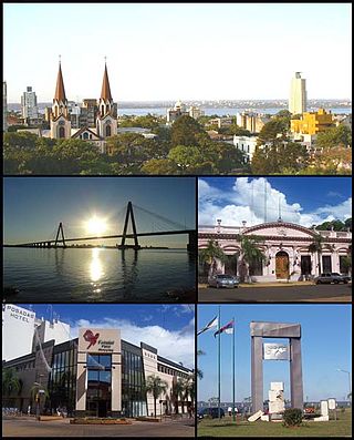
Posadas is the capital city of the Argentine province of Misiones, in its south, at the far north-east of the country on the left bank of the Paraná River, opposite Encarnación, Paraguay. The city has an area of 965 square kilometres (373 sq mi) and a population of 324,756, and the Greater Posadas area has a population of over 359,609 according to a 2017 estimate.

Nuevo Casas Grandes is a city and the seat of the Nuevo Casas Grandes Municipality in northern Mexico. It is located in the northwestern part of the state of Chihuahua, on the Casas Grandes or San Miguel river, situated in a wide, fertile valley on the 4,000-foot Mesa del Norte of the Plateau of Mexico. Nearby is the Sierra Madre Occidental.

Ramos Arizpe is a city and seat of the surrounding municipality of the same name in the Mexican state of Coahuila. Ramos Arizpe is located 11 km from the state capital of Saltillo. It is part of the Saltillo metropolitan area. The city reported a population of 48,228 in the 2005 census; the municipality had a population of 56,708. Its area is 5,306.6 km2.

Rioverde is a city and its surrounding municipality located in the south-central part of the state of San Luis Potosí, Mexico. It is the fifth-most populated city in the state, behind San Luis Potosí, Soledad de Graciano Sánchez, Ciudad Valles, and Matehuala. It is the agricultural, economic, turistic and demographic most important core in the Zona Media, one of the four geographical divisions of the state. The city had a 2005 census population of 49,183, while the municipality, of which it serves as municipal seat, had a population of 85,945 and an area extent of 3,064 km². The population of its metropolitan area, which includes the largest municipality of Ciudad Fernández, was 126,997.
Santiago Papasquiaro is a city located in a valley situated on the eastern slopes of the Sierra Madre Occidental in the state of Durango, Mexico. As of 2010, the city of Santiago Papasquiaro had a population of 26,121, while the municipality has a census population of 48,482 as of 2015. It is the fourth largest community in the state in terms of population, and is the municipal seat of the municipality of the same name. The municipality has an area of 7,238.4 km².

Aldama is a municipality of the northeastern Mexican state of Tamaulipas. According to the census of 2010, the municipality had an area of 3,672 square kilometres (1,418 sq mi) and a population of 29,470, including the town of Aldama with a population of 13,661.
Bernardo de Irigoyen is a city in the province of Misiones, Argentina. It has 10,889 inhabitants as per the 2001 census [INDEC], and is the head town of the General Manuel Belgrano Department. It carries the name of prominent politician and diplomat Bernardo de Irigoyen.
Altar is small city and municipal seat of Altar Municipality in the Mexican state of Sonora. It is located in the northwest region of the state at 30°42′49″N111°50′07″W.

Abasolo is a city located in the Mexican state of Tamaulipas. It is the seat of Abasolo Municipality.

Soto la Marina is a town in Soto la Marina Municipality located in the Mexican state of Tamaulipas. It was directly hit by Hurricane Alex in 2010. It is located on the banks of the Soto la Marina river, just up river from the small ocean port of La Pesca, and downriver from Ciudad Victoria, the capital of the State of Tamaulipas. 180 miles South of Brownsville, Texas, it is accessible from there via a highway in approximately 3 hours driving time.
Federal Highway 80 connects Tampico, Tamaulipas, to San Patricio, Jalisco. Federal Highway 80 connects the city of Guadalajara to the south coast in Jalisco. The highway runs through the towns of Acatlán de Juárez, Villa Corona, Cocula, Tecolotlán, Unión de Tula, Autlán, La Huerta, Casimiro Castillo, and San Patricio (Melaque).

Acatzingo Municipality is a municipality in the Mexican state of Puebla in south-eastern Mexico.

Ahuazotepec Municipality is a municipality in the Mexican state of Puebla in south-eastern Mexico.

General Zaragoza is a municipality and town of the northeastern Mexican state of Nuevo León. It is located in the south-eastern part of the state. The town is at 23°58′25″N99°46′23″W. The municipality has a total area of 508 square miles (1,315 km2) and had a population of 5,942 in 2010. Most of the population lives in the town of Zaragoza. The elevation of Zaragoza is 4,520 feet (1,379 m). Zaragoza is bordered by Aramberri, on the south and east by Hidalgo, Tamaulipas, and on the west by Doctor Arroyo.
Buenos Aires, the capital of Argentina, has a temperate climate, which is classified as a humid subtropical climate (Cfa) under the Köppen climate classification with four distinct seasons. Summers are hot and humid with frequent thunderstorms while winters are cool and drier with frosts that occurs on average twice per year. Spring and fall are transition seasons characterized by changeable weather. At the central observatory, the highest temperature recorded is 43.3 °C (109.9 °F), and the lowest temperature recorded is −5.4 °C (22.3 °F).

Citlaltépetl is a municipality in the Mexican state of Veracruz, located 223 kilometres (139 mi) northwest of the state capital of Xalapa and 99 kilometres (62 mi) south of the city of Tampico, Tamaulipas.
23°00′N99°43′W / 23°N 99.72°W
| | This article about a location in the Mexican state of Tamaulipas is a stub. You can help Wikipedia by expanding it. |
