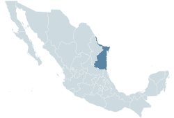
Tamaulipas, officially the Estado Libre y Soberano de Tamaulipas, is one of the 32 states which comprise the Federal Entities of Mexico. It is divided into 43 municipalities and its capital city is Ciudad Victoria.

Reynosa is a border city in the northern part of the state of Tamaulipas, in Mexico. It is also the municipal seat of Reynosa Municipality.

Tampico is a city and port in the southeastern part of the state of Tamaulipas, Mexico. It is located on the north bank of the Pánuco River, about 10 kilometers (6 mi) inland from the Gulf of Mexico, and directly north of the state of Veracruz. Tampico is the fifth-largest city in Tamaulipas, with a population of 314,418 in the city proper and 929,174 in the metropolitan area.

Ciudad Madero is a coastal city, located in southeast Tamaulipas in the Gulf of Mexico, It is the seventh most populous city in the state, with a census-estimated 2015 population of 209,175 within an area of 18.0 square miles the city is the third-largest in the Tampico metropolitan area, It is also an important center of oil refining in Mexico.
Las Choapas is a city and its surrounding municipality in the southeastern extremes of the state of Veracruz in Mexico. It is bordered by the municipalities of Uxpanapa, Minatitlán, Moloacán, and Agua Dulce in Veracruz, Huimanguillo in Tabasco, Cintalapa and Tecpatán in Chiapas, and Santa María Chimalapa in Oaxaca. Its major products are cattle breeding, corn, oil, fruit, sugar, and rubber. In the past it had a rice miller. It is one of the largest municipalities in Veracruz, with an area of 2,851.2 km². At the 2005 census the city had a population of 40,773 inhabitants, while the municipality had a population of 70,092. It is a very hot place, as temperature reaches up to 40 degrees Celsius. It has had some tornadoes in the past. It is connected to the communities of Raudales-Ocozocoautla in Chiapas through the Chiapas bridge.

Escuinapa de Hidalgo is a city in Escuinapa Municipality of the same name, located at the extreme southern end of the Mexican state of Sinaloa. Its geographical coordinates are 22°28′0″N105°26′17″W. At the census of 2005 the city had a population of 28,789 inhabitants, while the municipality reported 49,655 inhabitants. According to the Mexican Government, Escuinapa will have near 500,000 inhabitants in 2025 for the mega touristic center that are building near the town, and will be finished in 2025; with this information we can know Escuinapa de Hidalgo will be the second or third city more important in Sinaloa, also will be between the second and fourth place according population by municipality, maybe over Ahome and behind Mazatlán. The municipality has an area of 1633.22 km² and includes the towns of Isla del Bosque and Teacapan, in addition to many smaller localities.
Tuxpan is both a municipality and city located in the Mexican state of Veracruz. The population of the city was 78,523 and of the municipality was 134,394 inhabitants, according to the INEGI census of 2005, residing in a total area of 1,051.89 km2 (406.14 sq mi). The municipality includes many smaller outlying communities, the largest of which are Alto Lucero and Santiago de la Peña. A local beachside community is also nearby.

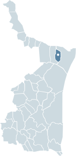
Altamira is a municipality in the Mexican state of Tamaulipas. It is located immediately to the north of the municipalities of Tampico and Ciudad Madero, at the southern tip of the state of Tamaulipas, on the Gulf of Mexico. Additionally, it borders the municipalities of González on the west and Aldama on the north, as well as Pánuco in the state of Veracruz on the southeast. Altamira can also refer to the city, founded in 1749, that is its municipal seat and second-largest community. The municipality is primarily made up of the cities of Miramar and Altamira, in addition to many smaller outlying towns such as Cuauhtémoc. The municipality has a total area of 1,666.53 km².
Lázaro Cárdenas is a port city in Michoacán bordered to the west by Guerrero. Lázaro Cárdenas is located in the southern part of the Mexican state of Michoacán. It was formerly known as Los Llanitos, but changed its name as a tribute to Lázaro Cárdenas del Río, a Michoacán-born politician who was president of Mexico from 1934 to 1940.

Apizaco is a city in Apizaco Municipality located near the geographic center of the Mexican state of Tlaxcala, approximately 25 minutes by car from the state's capital city of Tlaxcala. The city gets its name from the Nahuatl language words "ātl" (water), "pitzāhuac" (thin), and the suffix "co" (place), forming "Āpitzāco", or roughly "thin water place". Those seeking to reach the port of Veracruz by railroad from Mexico City must travel through Apizaco. The city began because of its location on this railroad.
Río Bravo, formally Ciudad Río Bravo, is a city on the northern border of the state of Tamaulipas in northeastern Mexico.
Miramar is a city near the southeastern tip of the state of Tamaulipas in Mexico. It is the largest city in the municipality of Altamira and third largest of the Tampico Metropolitan Area. The city had a 2010 census population of 118,614, the seventh-largest community in the state, having passed Río Bravo since the previous census.
Martínez de la Torre is a city and its surrounding municipality of the same name located in the central part of the Mexican state of Veracruz. The city had a 2005 census population of 56,433, while the municipality had a population of 97,768. There is a total area of 815.13 km² in the municipality. The largest other community in the municipality is the town of Independencia. Martinez de la Torre have the most taxi service that people use for their daily lives.
Buenavista is the largest town in Tultitlán Municipality in State of Mexico, Mexico. The town is part of the Mexico City metropolitan area and had a 2010 census population of 206,081 inhabitants, or 39.32% of its municipal population of 524,074. The town lies near the northern tip of the Federal District. It is the second-largest locality in Mexico that is not a municipal seat. Tultitlán Municipality's seat lies in the town of Tultitlán de Mariano Escobedo, with a population of 31,936.
Valle Hermoso is a city in Valle Hermoso Municipality in the northeastern part of the Mexican state of Tamaulipas. The city serves as the municipal seat of the municipality, which is bordered by the municipalities of Matamoros and Río Bravo. At the census of 2010 the city had a population of 48,918 inhabitants, while the municipality had a population of 63,170.

Matamoros is a municipality located in the Mexican state of Tamaulipas.
Tampico is a municipality located in the Mexican state of Tamaulipas. The largest city in it is Tampico, Tamaulipas.

Pabellón de Arteaga is municipality in the Mexican state of Aguascalientes. It stands at 22°09′N102°16′W in the central part of the state. The city of Pabellón de Arteaga serves as its municipal seat. The municipality had a population of 41,862 and an area of 199.33 km². Its largest other town is named Emiliano Zapata.
Pueblo Viejo is one of the 212 municipalities of the Mexican state of Veracruz. It is located in the state's Huasteca Alta region. The municipal seat is the city of Ciudad Cuauhtémoc, Veracruz.

The Tampico metropolitan area is the third most populous metropolitan area in the state of Tamaulipas, in the country of Mexico. Its in-state metropolitan area of Tamaulipas counts with the municipalities of Tampico, Ciudad Madero, Altamira. On the other hand, the out-of-state municipalities include Pueblo Viejo and Pánuco, from the state of Veracruz.