Ciudad Ocampo in Ocampo Municipality in the Mexican state of Tamaulipas was founded on May 19, 1749 as Villa of Santa Bárbara; the town became known as Ocampo in 1869. The credit for the founding of Santa Barbara is given to Don José Escandón y Helguera. It is at the southern border of the state, among the Sierra Madre Oriental Mountains. Surrounded by green mountains and hundreds of farms, it is known as "El Vergel de Tamaulipas", the Orchard of Tamaulipas. The name Ocampo is so named in honor of the reformist Melchor Ocampo.
Los Aldamas is a municipality located in the northeast part of the Mexican state of Nuevo León. Its geographic coordinates are 26°03′N99°11′W. It is bordered to the north by the state of Tamaulipas, to the south with the municipalities of Doctor Coss and China, to the east with the municipality of Dr. Coss, N.L and the state of Tamaulipas and to the west with the municipalities of General Treviño, Melchor Ocampo and Los Herreras, N.L.
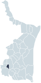
General Treviño is a municipality in Northern Mexico.
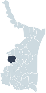
Melchor Ocampo is a municipality located in the Mexican state of Nuevo León. It is named after Don Melchor Ocampo, who was Foreign Minister during the government of Benito Juárez.

Nuevo Progreso, Tamaulipas also known as El Progreso is a community located in Nuevo Laredo Municipality in the Mexican state of Tamaulipas. According to the INEGI Census of 2010, El Progreso has a population of 432 inhabitants. Its elevation is 150 meters above sea level.
The Municipality of Nuevo Laredo is located in the Mexican state of Tamaulipas. Its municipal seat is Nuevo Laredo. The municipality contains more than 60 localities which the most important ones are Nuevo Laredo, El Campanario y Oradel, and Álvarez, the last two being suburbs of the city of Nuevo Laredo. By population, the municipality is the third largest in the state of Tamaulipas. The Nuevo Laredo municipality is the northernmost in Tamaulipas, lying at the extreme northwestern tip of its narrow strip of land along the Río Grande. The city of Nuevo Laredo contains approximately 97.5% of the total population of the municipality.

Rabé de las Calzadas is a municipality and town located in the province of Burgos, Castile and León, Spain. According to the 2004 census (INE), the municipality has a population of 154 inhabitants.
Ciudad Miguel Alemán, known prior to 1950 as San Pedro de Roma, is a city in the Mexican state of Tamaulipas, located across the Rio Grande from the U.S. city of Roma, Texas. The two are linked by the Roma – Ciudad Miguel Alemán International Bridge, a suspension bridge. As of 2010, the population of the city was 19,997. The total population of the surrounding municipality was 27,015.
Antiguo Morelos is a municipality located in the Mexican state of Tamaulipas.

Guerrero is a municipality located in the Mexican state of Tamaulipas.
Hidalgo Municipality is a municipality located in the Mexican state of Tamaulipas. El Chorrito is a centre of pilgrimage in the municipality.

Llera de Canales is a municipality located in the Mexican state of Tamaulipas. Also called Llera, the municipality has an area of 2,307 square kilometres (891 sq mi) and a 2010 population of 17,333. The population of the town of Llera is 4,148. Llera was founded December 25, 1748 and later renamed Llera de Canales.
Miquihuana Municipality is a municipality located in the Mexican state of Tamaulipas.
Nuevo Morelos is a municipality located in the Mexican state of Tamaulipas.

San Fernando is a municipality and city located in the Mexican state of Tamaulipas. It is about 85 miles (137 km) away from Brownsville, Texas. The municipality has a population of 57,220, while the city itself has a population of 29,665.
Victoria Municipality is a municipality located in the Mexican state of Tamaulipas.
Villagrán Municipality is a municipality in Tamaulipas, Mexico.

Koro Cercle is an administrative subdivision of the Mopti Region of Mali. The administrative center is the town of Koro.
Palmillas Municipality is located in Tamaulipas, Mexico.

Tula Municipality is one of the municipalities of Tamaulipas, Mexico. The seat is at Ciudad Tula.
This page is based on this
Wikipedia article Text is available under the
CC BY-SA 4.0 license; additional terms may apply.
Images, videos and audio are available under their respective licenses.


