
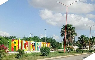
Matamoros, officially known as Heroica Matamoros, is a city in the northeastern Mexican state of Tamaulipas, and the municipal seat of the homonymous municipality. It is on the southern bank of the Rio Grande, directly across the border from Brownsville, Texas, United States. Matamoros is the second largest city in the state of Tamaulipas. As of 2016, Matamoros had a population of 520,367. In addition, the Matamoros–Brownsville Metropolitan Area has a population of 1,387,985, making it the 4th largest metropolitan area on the Mexico–US border. Matamoros is the 39th largest city in Mexico and anchors the second largest metropolitan area in Tamaulipas.

Tamaulipas, officially the Free and Sovereign State of Tamaulipas, is a state in Mexico; one of the 31 states which, along with Mexico City, comprise the 32 Federal Entities of Mexico. It is divided into 43 municipalities.

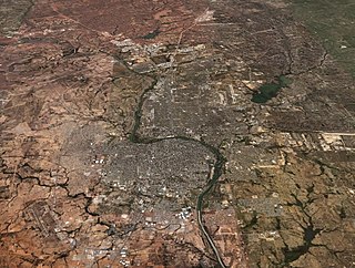
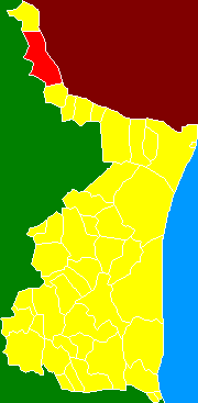
Reynosa is a border city in the northern part of the state of Tamaulipas, in Mexico which also holds the municipal seat of Reynosa Municipality.
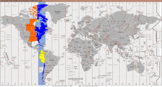
UTC−05:00 is an identifier for a time offset from UTC of −05:00. In North America, it is observed in the Eastern Time Zone during standard time, and in the Central Time Zone during the other eight months. The western Caribbean uses it year round.

Tamaulipas is a state in Northeast Mexico that is divided into 43 municipalities. According to the 2020 Mexican census, it is the fourteenth most populated state with 3,527,735 inhabitants and the sixth largest by land area spanning 80,249.3 square kilometres (30,984.4 sq mi).
UTC−06:00 is an identifier for a time offset from UTC of −06:00. In North America, it is observed in the Central Time Zone during standard time, and in the Mountain Time Zone during the other eight months. Several Latin American countries and a few other places use it year-round.
Federal Highway 40, also called the Carretera Interoceánica, is a road beginning at Reynosa, Tamaulipas, just west of the Port of Brownsville, Texas, and ending at Fed. 15 in Villa Unión, Sinaloa, near Mazatlán and the Pacific coast. It is called Interoceanic as, once finished, the cities of Matamoros, Tamaulipas, on the Gulf of Mexico and Mazatlán on the Pacific Ocean will be linked.
Camargo is a municipality in the Mexican state of Tamaulipas. It is located on the US border, across from Rio Grande City, Texas. It has an official population of 14,933 inhabitants. The municipal seat is Ciudad Camargo, with a population of 7,984. The municipality is connected to Rio Grande City, Texas, via the Rio Grande City-Camargo International Bridge.
Cadereyta Jiménez is the name of a city as well as of a municipality in the Mexican state of Nuevo León.
Río Bravo, formally Ciudad Río Bravo, is a city on the northern border of the state of Tamaulipas in northeastern Mexico.

Anáhuac Municipality is one of the municipalities of the Mexican state of Nuevo León. The city of Anáhuac was founded on May 5, 1933, inside the municipal jurisdiction of Lampazos de Naranjo, Nuevo León, as the political head of the National System of Irrigation No.04 (SNI). On May 29, 1935, this city was declared a municipality. By decision of the Government of the State the municipal territory annexed the abandoned community of Colombia, Nuevo León in 1978. From 1992, Anáhuac Municipality has received federal contributions for the commercial use of the Colombia-Solidarity International Bridge, which is the only international border crossing between Nuevo León and Texas. Anáhuac Municipality is divided into eight regions: Estación Rodríguez, Ejido Nuevo Rodríguez, Ejido Camarón, Ejido Nuevo Anáhuac, Ejido Rodríguez, Ciudad Anáhuac, Salinillas, and Regantes.
Laredo–Nuevo Laredo, otherwise known as the "Four-State Area" or the "Quad State Area", is one of six transborder agglomerations along the U.S.-Mexican border. The city of Laredo is situated in the U.S. state of Texas on the northern bank of the Rio Grande and Nuevo Laredo is located in the Mexican State of Tamaulipas in the southern bank of the river. This area is also known as the Two Laredos or the Laredo Borderplex. The area is made up of one county in the U.S and three municipalities in Mexico. Two urban areas, three cities, and 12 towns make the Laredo–Nuevo Laredo Metropolitan area. The two sides of the Borderplex are connected by four International Bridges and an International Railway Bridge. The Laredo–Nuevo Laredo Metropolitan area has a total of 636,516 inhabitants according to the INEGI Census of 2010 and the United States Census estimate of 2010. According to World Gazetteer this urban agglomeration ranked 157th largest in North and South America in 2010 with an estimated population of 675,481. This area ranks 66th in the United States and 23rd in Mexico.

The Municipality of Nuevo Laredo is located in the Mexican state of Tamaulipas. Its municipal seat is Nuevo Laredo. The municipality contains more than 60 localities which the most important ones are Nuevo Laredo, El Campanario y Oradel, and Álvarez, the last two being suburbs of the city of Nuevo Laredo. By population, the municipality is the third largest in the state of Tamaulipas. The Nuevo Laredo municipality is the northernmost in Tamaulipas, lying at the extreme northwestern tip of its narrow strip of land along the Río Grande. The city of Nuevo Laredo contains approximately 97.5% of the total population of the municipality.
Guerrero is a municipality located in the Mexican state of Tamaulipas.
Gustavo Díaz Ordaz is a municipality located in the Mexican state of Tamaulipas.

Joint Operation Nuevo León-Tamaulipas is an anti-drug joint operation in two Mexican states of Tamaulipas and Nuevo León by Federal Police and the Mexican Armed Forces. The objective of the joint operation is to eliminate Los Zetas and Gulf Cartel operations in the area. So far, many cartel members have been either killed or arrested. Recently Los Zetas and the Gulf Cartel have broken relations and started fighting each other.

Río Bravo Municipality is one of the municipalities in the Mexican state of Tamaulipas. The seat is at Río Bravo, Tamaulipas.

Valle Hermoso Municipality is one of the municipalities in the Mexican state of Tamaulipas. The seat is at the city of Valle Hermoso. At the census of 2010 the city had a population of 48,918 inhabitants, while the municipality had a population of 63,170. The municipality has an area of 916.43 km2. Its largest other localities are the towns of Anáhuac in the northeastern part of the municipality and El Realito to the west of the city of Valle Hermoso.

Reynosa–McAllen, also known as McAllen–Reynosa, or simply as Borderplex, is one of the six international conurbations along the Mexico–U.S border. The city of Reynosa is situated in the Mexican state of Tamaulipas, on the southern bank of the Rio Grande, while the city of McAllen is located in the American state of Texas, directly north across the bank of the Rio Grande. This area has a population of roughly 1,500,000, making it the largest and most populous in the state of Tamaulipas, and third most populous on the US–Mexico border.
Federal Highway 40D is the designation for toll highways paralleling Mexican Federal Highway 40. Highway 40D connects Mazatlán, Sinaloa to Reynosa, Tamaulipas. It forms most of the highway corridor between Mazatlán and Matamoros, Tamaulipas, one of 14 major highway corridors in the country.


