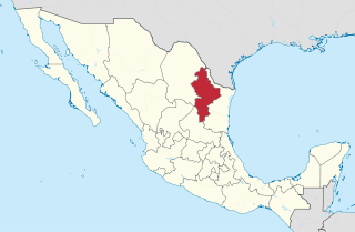
Nuevo León, officially the Free and Sovereign State of Nuevo León, is a state in northeastern Mexico. The state borders the Mexican states of Tamaulipas, Coahuila, Zacatecas, and San Luis Potosi, and has an extremely narrow international border with the U.S. state of Texas. Covering 64,156 square kilometers and with a population of 5.78 million people, Nuevo León is the thirteenth-largest federal entity by area and the seventh-most populous as of 2020.

Tamaulipas, officially the Free and Sovereign State of Tamaulipas, is a state in Mexico; one of the 31 states which, along with Mexico City, comprise the 32 federal entities of Mexico. It is divided into 43 municipalities.

Ciudad Victoria is the seat of the Municipality of Victoria, and the capital of the Mexican state of Tamaulipas. It is located in the northeast of Mexico at the foot of the Sierra Madre Oriental. It borders the municipality of Güémez to the north, Llera to the south, Casas Municipality to the east, and the municipality of Jaumave to the west. The city is located 246 km (153 mi) from Monterrey and 319 km (198 mi) from the US - Mexico border. Ciudad Victoria is named after the first president of Mexico, Guadalupe Victoria.

José de Escandón y Helguera, conde de Sierra was a Spanish Indian-fighter in New Spain and the founder and first governor of the colony of Nuevo Santander, which extended from the Pánuco River in the modern-day Mexican state of Tamaulipas to the Guadalupe River in the modern-day U.S. state of Texas.

The Sierra Madre Oriental is a mountain range in northeastern Mexico. The Sierra Madre Oriental is part of the American Cordillera, a chain of mountain ranges (cordillera) that consists of an almost continuous sequence of mountain ranges that form the western "backbone" of North America, Central America, South America, and Antarctica.

Nuevo Santander was a region of the Viceroyalty of New Spain, covering the modern Mexican state of Tamaulipas and extending into modern-day southern Texas in the United States.

Aldama is a municipality of the northeastern Mexican state of Tamaulipas. According to the census of 2010, the municipality had an area of 3,672 square kilometres (1,418 sq mi) and a population of 29,470, including the town of Aldama with a population of 13,661.

Mante, formally Ciudad Mante, is a city in the Mexican state of Tamaulipas. The city is the municipal seat of El Mante municipality in extreme southern Tamaulipas, and lies in the northwestern portion of the municipality. It had a 2005 census population of 81,884 inhabitants, or about 73 percent of El Mante's total of 112,061. The city is the state's ninth-largest community in population. El Mante has an area of 1,699.98 km2, and includes smaller outlying communities such as Celaya, El Limón, El Abra, Nueva Apolonia, and El Naranjo. Ciudad Mante is served by the Ciudad Mante National Airport.

Juan Francisco de Güemes y Horcasitas was a Spanish general, governor of Havana, captain general of Cuba, and viceroy of New Spain.

The Veracruz moist forests is a tropical moist broadleaf forests ecoregion in eastern Mexico.

Tamasopo is a municipality and town in the Mexican state of San Luis Potosí. The town is located at 21°55′21″N99°23′33″W. The municipality has an area of 1,329 square kilometres (513 sq mi) and a population of 28,848 in 2010, including the population of the town of Tamasopo with 4,326 people.
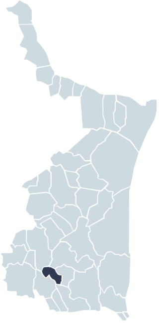
Gómez Farías Municipality is situated in the Mexican state of Tamaulipas. The town of Gómez Farías serves as the municipal seat of government. Covering an area of 433 square kilometres, Gómez Farías Municipality had a population of 8,786 as of 2010. The town of Gómez Farías, specifically, had a population of 883 in the same year. Additionally, within the municipal area, a portion of 23,124 hectares is encompassed by the El Cielo Biosphere Reserve.

Padilla Municipality is a municipality in the Mexican state of Tamaulipas. After the flood at the Vicente Guerrero Dam in 1970, the seat was moved from Padilla to the town of Nuevo Padilla.

El Naranjo is a town and a municipality in the Mexican state of San Luis Potosí in central Mexico. The municipality, created in 1994, has an area of 834 square kilometres (322 sq mi) with a population of 20,495 in 2010, including the town of El Naranjo with a population of 10,562. The town is located at 22°31′19″N99°19′31″W.

General Zaragoza is a municipality and town of the northeastern Mexican state of Nuevo León. It is located in the south-eastern part of the state. The town is at 23°58′25″N99°46′23″W. The municipality has a total area of 508 square miles (1,315 km2) and had a population of 5,942 in 2010. Most of the population lives in the town of Zaragoza. The elevation of Zaragoza is 4,520 feet (1,379 m). Zaragoza is bordered by Aramberri, on the south and east by Hidalgo, Tamaulipas, and on the west by Doctor Arroyo.
The Sierra de Tamaulipas is an isolated, semi-tropical mountain range in the Mexican state of Tamaulipas. Its highest point is 1,260 m (4,130 ft). There are no cities or towns in the Sierra and the small population is largely agricultural. The higher elevations of the Sierra have forests of oak and pine, contrasting with the semi-arid brush that dominates at lower altitudes. Several archaeological sites establish that the Sierra de Tamaulipas was the northern outpost of the agricultural Mesoamerican peoples of eastern Mexico.

Sierra de San Carlos, also known as the Sierra Chiquita, is an isolated mountain range in the state of Tamaulipas, Mexico. The climate is semi-arid. The highest point is Cerro El Hongo with an elevation of 1,786 metres (5,860 ft) at a location of 24° 34′ 20″ North Latitude and 99° 04′ 24″ West Longitude. Most of the San Carlos range is much lower, averaging 600 metres (2,000 ft) to 800 metres (2,600 ft) in elevation.
The Sierra de Picachos is a mountain range located in the state of Nuevo Leon, Mexico. The highest peak in the range reaches an elevation of 4,990 feet (1,521 m) at 26° 03′ 54″ North Latitude and 99° 54′ 56″ West Longitude.

The El Cielo Biosphere Reserve is located in the Sierra Madre Oriental in the southern part of the Mexican state of Tamaulipas near the town of Gómez Farias. The reserve protects the northernmost extension of tropical forest and cloud forest in Mexico. It has an area of 144,530 hectares made up mostly of steep mountains rising from about 200 metres (660 ft) to a maximum altitude of more than 2,300 metres (7,500 ft).
Alta Cima is a village located within El Cielo Biosphere Reserve, in the municipality of Gómez Farías in Tamaulipas, Mexico. There are approximately 180 residents living in 40 households. The nearest cities are Ciudad Mante and Ciudad Victoria.

