Corozal Town

Last updated
Corozal Town
Aerial of Corozal Town, Belize.jpg
Aerial of Corozal Town
Belize location map.svg
Red pog.svg
Corozal Town
Map of Corozal metropolitan area
Coordinates: 18°24′N88°24′W / 18.4°N 88.4°W / 18.4; -88.4
Country Flag of Belize.svg  Belize
District Corozal
Constituency Corozal Bay, Corozal North
Government
  Mayor

•Area Representative Corozal North

•Area Representative Corozal Bay

•Area Representative Corozal South East

•Area Representative Corozal South West
Rigo Vellos (PUP)

Hon. Hugo Patt (UDP)

Hon. Elvia Vega Samos (PUP)

Hon. Florencio Marin jr. (PUP)

Hon. Ramiro Ramirez (PUP)
Elevation
0 m (0 ft)
Population
 (2010) [1]
  Total10,287
  Estimate 
(2017) [2]
13,502
Demonym Corozaleño(a)
Time zone UTC-6 (Central)
Climate Aw
Website corozal.com OOjs UI icon edit-ltr-progressive.svg

Corozal Town is a town in Belize, capital of Corozal District. Corozal Town is located about 84 miles north of Belize City, and 9 miles from the border with Mexico. The population of Corozal Town, according to the main results of the 2010 census, is 9,871.

Contents

Corozal was a private estate before becoming a town in the 1840s, mostly settled by Maya Mestizo refugees from the Caste War of Yucatán. Much of the town was built over an ancient Maya city, sometimes known as Santa Rita; this may have been the original Pre-Columbian town called Chactemal, which extended from present day Corozal to Chetumal, Mexico. Corozal Town was badly damaged by Hurricane Janet in 1955 and was substantially rebuilt afterward.

History

Corozal, the northmost town in Belize, was founded in 1848 by refugees from the Maya Indian uprising against the Spanish in neighboring Yucatán. This uprising, known as the Caste War of Yucatán (from the Spanish "castes" or race), began as a war against the Spaniards, but it eventually became a war against the Mestizos. The Mestizos, half Spanish and half Indian, had proved to be formidable allies of the Spaniards and were thus mortal enemies of the Maya Indians.

A massacre at Bacalar, Mexico — a Mestizo stronghold about thirty miles north of Corozal Town — finally led to the exodus of thousands of Mestizos from Bacalar and the surrounding area. Between 1848 and 1856 more than 10,000 refugees crossed the Rio Hondo, the river that now serves as a boundary between Belize and Mexico. These immigrants sought refuge in northern Belize and increased the population of Corozal Town to 4500. Mr. James Blake, a magistrate, let them settle on lands in the Corozal District and helped them to establish the new crop — sugar cane.

The Mestizo refugees were far from safe in Corozal Town as the Maya Indians from the Mexican base in Santa Cruz Bravo — today Carrillo Puerto — made several incursions in Corozal Town. In defense, Corozal became a garrison town and Fort Barlee was built here in 1870. Today, the brick corner supports of the fort surround the post office complex of the buildings across from the central town square.

The immigrants brought with them Maya Mestizo culture: Spanish and Yucatec Maya language, Catholicism and Maya folklore, the use of alcalde, their family structure and way of life. Soon, there emerged a local replication of the society of the Yucatán within the boundaries of a country ruled by English expatriates.

Across the bay from Corozal Town are the mounds of Cerros, the first Maya coastal trading center. Cerros is considered one of the most important late preclassic Maya sites because it represented the first experiment with kingship in the Maya world. The remains include a number of temples, plazas, ball courts, canals, and minor structures. The most interesting artifacts so far discovered are the five jade head pendants.

Within Corozal, itself can be found another Maya ruins from the fourteenth century AD. Known as Santa Rita, the pyramid site sits atop the remains of a Maya city that dominated the area for more than 2000 years, and burial sites rich in jewelry and artifacts have been unearthed there. The monument is said to be the center of ancient Chactemal, the Maya capital of the area at the time of the first Spanish attempt to conquer the Yucatec Mayas in the early 16th century. [3] The ruins of Santa Rita is located near the town's Hospital and is surrounded by the villages of San Andres, San Antonio, and Paraiso, by walking distances. An estimated 90% of the town was destroyed by Hurricane Janet in 1955, and most of the present structures post-date that hurricane.

The town is served by Corozal Hospital.

Climate

Climate data for Corozal Town (1981–2010)
MonthJanFebMarAprMayJunJulAugSepOctNovDecYear
Mean daily maximum °C (°F)28.3
(82.9)
30.3
(86.5)
31.6
(88.9)
32.8
(91.0)
33.1
(91.6)
32.8
(91.0)
32.6
(90.7)
32.7
(90.9)
33.0
(91.4)
31.7
(89.1)
29.9
(85.8)
28.7
(83.7)
31.5
(88.7)
Daily mean °C (°F)22.8
(73.0)
24.5
(76.1)
25.4
(77.7)
26.7
(80.1)
28.1
(82.6)
28.3
(82.9)
28.0
(82.4)
27.9
(82.2)
27.8
(82.0)
26.6
(79.9)
24.7
(76.5)
23.5
(74.3)
26.2
(79.2)
Mean daily minimum °C (°F)17.3
(63.1)
18.7
(65.7)
19.1
(66.4)
20.7
(69.3)
23.0
(73.4)
23.8
(74.8)
23.4
(74.1)
23.2
(73.8)
22.7
(72.9)
21.6
(70.9)
19.5
(67.1)
18.2
(64.8)
20.9
(69.6)
Average precipitation mm (inches)58.5
(2.30)
31.9
(1.26)
32.1
(1.26)
45.7
(1.80)
107.5
(4.23)
216.8
(8.54)
140.4
(5.53)
172.6
(6.80)
195.7
(7.70)
193.7
(7.63)
95.5
(3.76)
64.8
(2.55)
1,355.2
(53.36)
Average precipitation days (≥ 1.0 mm)74336131112131297100
Source: National Meteorological Service of Belize [4]

Demographics

At the time of the 2010 census, Corozal had a population of 10,287. Of these, 66.2% were Mestizo, 12.7% Creole, 9.4% Mixed, 3.1% East Indian, 2.5% Asian, 1.2% Garifuna, 1.1% Caucasian, 1.0% Hindu, 0.8% Ketchi Maya, 0.5% Lebanese, 0.5% Yucatec Maya, 0.3% African, 0.2% Mopan Maya, 0.2% Mennonite and 0.2% others.

In terms of languages spoken (multiple answers allowed), 77.8% spoke Spanish, 75.8% English, 35.1% Creole, 2.5% Mandarin or Cantonese, 1.0% Hindi, 0.8% Garifuna, 0.5% Yucatec Maya, 0.2% Ketchi Maya, 0.2% Mopan Maya, 0.1% German and 0.8% other languages; 0.2% could not speak. [5]

Recreation

Corozal Town will have a radio telescope at the Wernher von Braun Observatory, owned by NASA.

In June 2020, the Corozal Town Council led by Mayor Rigo Vellos received a development proposal for an eco-friendly, world-class water park. [6] Maximum Water Park opened to the public in April 2021. [7]

Related Research Articles

<span class="mw-page-title-main">Demographics of Belize</span> Demographics of country

Demographics of the population of Belize include population density, ethnicity, education level, health of the populace, economic status, religious affiliations and other aspects.

<span class="mw-page-title-main">Punta Gorda, Belize</span> Town in Toledo, Belize

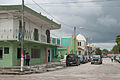
Punta Gorda, known locally as P.G., is the capital and largest town of Toledo District in southern Belize. Punta Gorda is the southernmost sizable town in the nation, with a population of about 5,000 people. Although the town bears a Spanish name, its inhabitants are mostly Kriol/English-speaking and are primarily of Garifuna, East Indian, Kriol, and Maya descent.

<span class="mw-page-title-main">Benque Viejo del Carmen</span> Town in Cayo District, Belize

Benque Viejo del Carmen ("Benque") is the westernmost town in Belize, 130 km (81 mi) by road west and south of Belize City, at the Guatemalan border. San Ignacio lies 13 km to the east and Melchor de Mencos just across the border. The Mopan River runs along the town's north and west edges.

<span class="mw-page-title-main">Corozal District</span> Northernmost district of Belize

Corozal District is the northernmost district of the nation of Belize. The population was 33,894 in 2000. The district capital is Corozal Town.

Trial Farm is a village near Orange Walk Town in the Orange Walk District of the nation of Belize. According to the 2000 census, it had a population of 3,443 people. It is located at 29 metres above sea level.

Progreso is a village in the Corozal District of the nation of Belize.

Xaibe is a small rural settlement in the country of Belize mainly consisting of people from the Yucatec Maya ethnicity. It is located in Corozal District. The name Xaibe literally means 'crossroads'. The people of the Maya civilization often traversed across the village to reach other Maya villages. The population of the village is very small. The last available data of the population of Xaibe in 2010 revealed that it had a modest population of approximately 1,575 people. There is, however, evidence of the fact that the people belonging to the Maya civilization resided in the Xaibe village. These people then gradually shifted to Mexico, just across the border at the time of the Caste War of Yucatán. The village is known for celebrating the Maya tradition Hanal Pixan which means "food for the souls" also known as Day of the Dead.

<span class="mw-page-title-main">Spanish Lookout</span> Place in Cayo District, Belize

Spanish Lookout is a settlement in the Cayo District of Belize in Central America. According to the 2010 census, Spanish Lookout had a population of 2,253 people in 482 households. Spanish Lookout is a community of Mennonites.

<span class="mw-page-title-main">Languages of Belize</span>

The major languages spoken in Belize include English, Spanish and Kriol, all three spoken by more than 40% of the population. Mayan languages are also spoken in certain areas, as well as German.

<span class="mw-page-title-main">San Joaquín, Corozal</span> Place in Corozal District, Belize

San Joaquín is a village in the Corozal District of Belize. It is one of the largest villages in Corozal. The town was formed as a result of Mestizos migrating to escape the 1847–1901 Caste War of Yucatán.

<span class="mw-page-title-main">Calcutta, Belize</span> Place in Corozal District, Belize

Calcutta is a village in the Corozal District of Belize.

Sarteneja is the largest fishing community and the second largest village in Belize. It recorded a population of 3,500 according to a 2016 estimate. The name Sarteneja is a Castilian distortion of its original Mayan name Tza-ten-a-ha, which means 'give me water'.

<span class="mw-page-title-main">Copper Bank</span> Place in Corozal District, Belize

Copper Bank is a fishing village in the Corozal District of Belize. It is situated on the west bank of Laguna Seca, a shallow lagoon that empties into Chetumal Bay just north-east of the village. The closest settlement is Chunox, located approximately 1.25 miles away on the east bank of the Laguna Seca.

Armenia is a village in the Cayo District of Belize, along the nation's Hummingbird Highway south of the capitol, Belmopan.

Big Falls is a populated settlement located in the nation of Belize. It is a mainland village that is located in Toledo District.

La Democracia is a populated settlement located in the nation of Belize. It is a mainland village that is located in Belize District.

<span class="mw-page-title-main">Bullet Tree Falls</span> Place in Cayo District, Belize

Bullet Tree Falls is a village located along the Mopan River in Cayo District, Belize. It lies approximately five kilometers northwest of San Ignacio. According to the 2010 census, Bullet Tree Falls has a population of 2,124 people in 426 households. The population consists mainly of Spanish-speaking mestizos, along with a smaller number of Maya and Creoles.

<span class="mw-page-title-main">Hispanic and Latin American Belizean</span>

Hispanic and Latin American Belizeans are Belizeans of full or partial Hispanic and Latin American descent. Currently, they comprise around 52.9% of Belize's population.

Chan Chen is a village located in Corozal District, Belize. Most of the inhabitants speak Spanish or Yucatec Maya, along with some English. The name Chan Chen is Yucatec maya meaning "small well" in English. Most Chan Chen inhabitants are of Maya ancestry.

<span class="mw-page-title-main">San Narciso, Belize</span> Village in Corozal District

San Narciso is a village in Corozal District, Belize. It is part of the Corozal South West constituency.

References

  1. "Belize Population and Housing Census 2010" (PDF). Statistical Institute of Belize. 2013. Archived from the original (PDF) on 27 January 2016. Retrieved 14 May 2016.
  2. "Mid-Year Population Estimates by Area and Sex 2008 - 2015". Statistical Institute of Belize. Retrieved 14 May 2016.[ permanent dead link ]
  3. Moody, Duane (23 February 2016). "Traditional Mayan Culture Kept Alive in the North". Channel 5 Belize. Great Belize Productions Ltd. Retrieved 8 December 2020.
  4. "Climatology Information for a few stations across Belize". National Meteorological Service of Belize. Archived from the original on March 24, 2021. Retrieved 2 August 2016.
  5. Population & Housing Census 2010
  6. "Maximum Water Park". ambergriscaye.com. Retrieved 17 April 2021.
  7. "Maximum Water Park". corozal.com. Retrieved 17 April 2021.