Benton, Louisiana

Last updated

Benton, Louisiana
Town
Town of Benton
Bossier Parish Courthouse IMG 2378.JPG
Bossier Parish Louisiana Incorporated and Unincorporated areas Benton Highlighted.svg
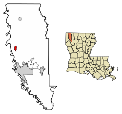
Location of Benton in Bossier Parish, Louisiana.
Louisiana in United States (US48).svg
Location of Louisiana in the United States
Coordinates: 32°41′50″N93°44′26″W / 32.69722°N 93.74056°W / 32.69722; -93.74056
CountryUnited States
StateLouisiana
Parish Bossier
Government
Area
[1]
  Total2.52 sq mi (6.53 km2)
  Land2.52 sq mi (6.52 km2)
  Water0.01 sq mi (0.02 km2)
Elevation
207 ft (63 m)
Population
 (2020)
  Total2,048
  Rank BO: 3rd
  Density813.99/sq mi (314.29/km2)
Time zone UTC-6 (CST)
  Summer (DST) UTC-5 (CDT)
ZIP Code
71006
Area code 318
FIPS code 22-06925
Website Benton, Louisiana

Benton is a town in, and the parish seat of, Bossier Parish, in the U.S. state of Louisiana. The population was 2,048 in 2020. [2] The town is named for 19th century U.S. Senator Thomas Hart Benton, a Democrat from Missouri and an ally of U.S. President Andrew Jackson. [3]

Contents

History

On April 3, 1999, a powerful F4 tornado roared through portions of the town killing six people and injuring 90. A mobile home park located south of town and homes near the Palmetto Country Club were devastated. Neighborhoods affected included Haymeadow Trailer Park, Palmetto Park/Palmetto Place (adjacent to the country club), Bay Hills, Woodlake South, Twin Lake Community, and many other newer lakefront homes located around Cypress Lake. The population of Benton lakefront area nearly doubled between 2004 and 2008. [4]

Geography

Benton is located at 32°41′41″N93°44′26″W / 32.69472°N 93.74056°W / 32.69472; -93.74056 (32.694607, -93.740595). [5]

According to the United States Census Bureau, the town has a total area of 1.9 square miles (4.9 km2), all land.

Demographics

Historical population
CensusPop.Note
1930 402
1940 51929.1%
1950 74142.8%
1960 1,33680.3%
1970 1,49311.8%
1980 1,86424.8%
1990 2,0479.8%
2000 2,035−0.6%
2010 1,948−4.3%
2020 2,0485.1%
U.S. Decennial Census [6]
Benton racial composition as of 2020 [2]
RaceNumberPercentage
White (non-Hispanic)1,08352.88%
Black or African American (non-Hispanic)71935.11%
Native American 110.54%
Asian 261.27%
Other/Mixed 1165.66%
Hispanic or Latino 934.54%

As of the 2020 United States census, there were 2,048 people, 850 households, and 516 families residing in the town. [2]

Education

The community is in the Bossier Parish School District. [7]

Benton Elementary School's attendance zone includes almost all of Benton. [8] A small portion of Benton is within the boundary of Kingston Elementary School. [9] All of Benton is in the attendance zones of: Benton Intermediate School, [10] Benton Middle School, [11] and Benton High School. [12]

Bossier Parish is in the areas of Bossier Parish Community College and Northwest Louisiana Technical Community College. [13]

Notable people

Related Research Articles

<span class="mw-page-title-main">Bossier Parish, Louisiana</span> Parish in Louisiana, United States

Bossier Parish is a parish located in the northwestern part of the U.S. state of Louisiana. At the 2020 census, the population was 128,746.

<span class="mw-page-title-main">Bossier City, Louisiana</span> City in Louisiana, United States

Bossier City is a city in Bossier Parish in the northwestern region of the state of Louisiana in the United States. It is the second-most populous city in the Shreveport–Bossier City metropolitan statistical area. In 2020, it had a total population of 62,701, up from 61,315 in 2010.

Eastwood is an unincorporated community and census-designated place (CDP) in Bossier Parish, Louisiana, United States. The population was 4,093 at the 2010 census. It is part of the Shreveport–Bossier City Metropolitan Statistical Area.

<span class="mw-page-title-main">Haughton, Louisiana</span> Town in Louisiana, United States

Haughton is a town in Bossier Parish, Louisiana, United States. The population was 4,539 in 2020. It is part of the Shreveport–Bossier City metropolitan statistical area.

<span class="mw-page-title-main">Plain Dealing, Louisiana</span> Town in Louisiana, United States

Plain Dealing is a town in Bossier Parish, Louisiana, United States. The population was 893 in 2020. It is part of the Shreveport–Bossier City metropolitan statistical area.

Red Chute is an unincorporated community and census-designated place (CDP) in Bossier Parish, Louisiana, United States. The population was 6,261 at the 2010 census. It is part of the Shreveport–Bossier City Metropolitan Statistical Area.

<span class="mw-page-title-main">Avondale, Louisiana</span> Census-designated place in Louisiana, United States

Avondale is a census-designated place (CDP) in Jefferson Parish, Louisiana, United States, on the west bank of the Mississippi River. The population was 4,582 in 2020. It is part of the New Orleans–Metairie–Kenner metropolitan statistical area.

<span class="mw-page-title-main">Bridge City, Louisiana</span> Census-designated place in Louisiana, United States

Bridge City is an unincorporated community and census-designated place (CDP) in Jefferson Parish, Louisiana, United States. It was established in the 1930s during the construction of the Huey P. Long Bridge over the Mississippi River. The town is located on the south side of the river. It is part of the New Orleans–Metairie–Kenner metropolitan statistical area.

Elmwood is a census-designated place (CDP) in Jefferson Parish, Louisiana, United States, within the New Orleans–Metairie–Kenner metropolitan statistical area. The population was 4,635 at the 2010 census, and 5,649 in 2020. Elmwood was part of neighboring Jefferson's census area from 1960 to 1990. The ZIP Code serving Elmwood is 70123.

Estelle is a census-designated place (CDP) in Jefferson Parish, Louisiana, United States. The population was 17,952 in 2020. It is part of the New Orleans–Metairie–Kenner metropolitan statistical area.

<span class="mw-page-title-main">Harvey, Louisiana</span> Census-designated place in Louisiana, United States

Harvey is a census-designated place (CDP) in Jefferson Parish, Louisiana, United States. Harvey is on the south side of the Mississippi River, within the New Orleans–Metairie–Kenner metropolitan statistical area. The majority-minority population was 20,348 at the 2010 census, down from 22,226 at the 2000 census. The 2020 census determined 22,236 people lived in the CDP.

<span class="mw-page-title-main">Marrero, Louisiana</span> Census-designated place in Louisiana, United States

Marrero is a census-designated place (CDP) in Jefferson Parish, Louisiana, United States. Marrero is on the south side of the Mississippi River, within the New Orleans–Metairie–Kenner metropolitan statistical area. The population was 32,382 at the 2020 U.S. census.

<span class="mw-page-title-main">Terrytown, Louisiana</span> Census-designated place in Louisiana, United States

Terrytown is an unincorporated community and census-designated place (CDP) in Jefferson Parish, Louisiana, United States. It is on the "Westbank" of the Mississippi River. It is a suburb within the New Orleans–Metairie–Kenner metropolitan statistical area. The population was 23,319 at the 2010 census, and 25,278 in 2020.

Timberlane is a census-designated place (CDP) in Jefferson Parish, Louisiana, United States. The population was 10,364 in 2020. It is part of the New Orleans–Metairie–Kenner metropolitan statistical area.

Woodmere is an unincorporated community and census-designated place (CDP) in Jefferson Parish, Louisiana, United States. The population was 12,080 at the 2010 census, and 11,238 at the 2020 census. It is part of the New Orleans–Metairie–Kenner metropolitan statistical area.

<span class="mw-page-title-main">Shreveport–Bossier City metropolitan area</span> Metropolitan area in Louisiana, United States

The Shreveport–Bossier City metropolitan area, officially designated Shreveport–Bossier City by the U.S. Office of Management and Budget, or simply Greater Shreveport, is a metropolitan statistical area in northwestern Louisiana that covers three parishes: Caddo, Bossier, and DeSoto. At the 2020 United States census, the metropolitan region had a population of 393,406; its American Community Survey population was 397,590 per census estimates. With a 2010 census population of 439,000, it declined to become Louisiana's fourth largest metropolis at 394,706 residents at the 2019 census estimates.

Bossier Parish School Board is a school district headquartered in Benton, Louisiana, United States. The Superintendent of Bossier Schools is, as of 2024, Jason Rowland.

Princeton is an unincorporated community in Bossier Parish, Louisiana, United States. It is part of the Shreveport-Bossier City Metropolitan Statistical Area. The ZIP Code for Princeton is 71067.

<span class="mw-page-title-main">Haughton High School</span> Public school in Haughton, Bossier Parish, Louisiana, United States

Haughton High School is a public high school in Haughton, Louisiana, United States that enrolls 1,159 students from grades 9–12. The school received an "A" rating by the Louisiana Department of Education. It is administered by Bossier Parish Schools. 80% of students received a four-year diploma, compared to 79% in the district and 74% statewide. The Haughton Buccaneers play in district District 1-5A.

<span class="mw-page-title-main">Bossier High School (Louisiana)</span> Public school, college prep school in Bossier City, Louisiana, United States

Bossier High School is a co-educational college preparatory high school in Bossier City, Louisiana, United States.

References

  1. "2020 U.S. Gazetteer Files". United States Census Bureau. Retrieved March 20, 2022.
  2. 1 2 3 "Explore Census Data". data.census.gov. Retrieved December 29, 2021.
  3. "Kay McMahan, "Bossier Parish, LA, Towns"". usgwarchives.net. Retrieved July 2, 2013.
  4. USA Today - 04 April 1999
  5. "US Gazetteer files: 2010, 2000, and 1990". United States Census Bureau. February 12, 2011. Retrieved April 23, 2011.
  6. "Census of Population and Housing". Census.gov. Retrieved June 4, 2015.
  7. "2020 CENSUS - SCHOOL DISTRICT REFERENCE MAP: Bossier Parish, LA" (PDF). U.S. Census Bureau . Retrieved March 9, 2024. - Text list
  8. "Benton Elementary School Attendance Zone Map" (PDF). Bossier City School Board . Retrieved March 9, 2024.
  9. "Kingston Elementary School Attendance Zone Map" (PDF). Bossier City School Board . Retrieved March 9, 2024.
    Compare to: "2020 CENSUS - CENSUS BLOCK MAP: Benton town, LA" (PDF). U.S. Census Bureau . Retrieved March 9, 2024.
  10. "Benton Intermediate School Attendance Zone Map" (PDF). Bossier City School Board . Retrieved March 9, 2024.
  11. "Benton Middle School Attendance Zone Map" (PDF). Bossier City School Board . Retrieved March 9, 2024.
  12. "Benton High School Attendance Zone Map" (PDF). Bossier City School Board . Retrieved March 9, 2024.
  13. "Our Colleges". Louisiana's Technical and Community Colleges . Retrieved March 9, 2024. shows Bossier Parish in the service areas of BPCC and NLTCC.
  14. U.S. Search, People Search and Background Check, Internet
  15. "Louisiana State University e-yearbooks". e-yearbook.com. Retrieved July 19, 2009.
  16. "Dewey E. Burchett, Jr". The Shreveport Times . November 22, 2009. Retrieved June 26, 2015.
  17. "Membership of the Louisiana House of Representatives, 1812-2016 (Bossier and Webster parishes)" (PDF). house.louisiana.gov. Archived from the original (PDF) on October 6, 2014. Retrieved February 2, 2013.
  18. "Mike Johnson State Representative". mikejohnsonlouisiana.com. Retrieved March 30, 2015.
  19. ""John A. W. Lowry of Bossier Parish, Louisiana" in Biographical and Historical Memoirs of Northwest Louisiana". Chicago and Nashville, Tennessee: Southern Publishing Company. 1890. Retrieved March 23, 2015.
  20. Jimmy Watson (September 30, 2014). "LSU basketball great George Nattin Jr. loved his golf". The Shreveport Times. Retrieved February 16, 2015.
  21. "Social Security Death Index". rootsweb.ancestry.com. Retrieved July 20, 2009.