Bayou Cane, Louisiana

Last updated

Bayou Cane, Louisiana
USA Louisiana location map.svg
Red pog.svg
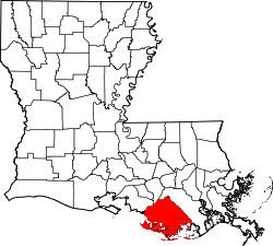
Bayou Cane, Louisiana
Location of Bayou Cane in Louisiana
Coordinates: 29°37′35″N90°44′54″W / 29.62639°N 90.74833°W / 29.62639; -90.74833
CountryUnited States
StateLouisiana
Parish Terrebonne
Area
[1]
  Total
7.61 sq mi (19.72 km2)
  Land7.61 sq mi (19.72 km2)
  Water0 sq mi (0.00 km2)
Elevation
7 ft (2.1 m)
Population
 (2020)
  Total
19,770
  Density2,597.0/sq mi (1,002.71/km2)
Time zone UTC-6 (CST)
  Summer (DST) UTC-5 (CDT)
Area code 985
FIPS code 22-05210

Bayou Cane is a census-designated place (CDP) in Terrebonne Parish, Louisiana, United States. It is located just north of Houma and had a population of 19,770 in 2020.

Contents

Bayou Cane is the principal city of the HoumaBayou Cane Thibodaux metropolitan statistical area, which includes all of Terrebonne and Lafourche parishes.

Geography

Bayou Cane is located at 29°37′35″N90°44′54″W / 29.62639°N 90.74833°W / 29.62639; -90.74833 (29.626285, -90.748396). [2]

According to the United States Census Bureau, the CDP has a total area of 7.6 square miles (20 km2), all land.

Demographics

Historical population
CensusPop.Note
1950 2,212
1960 3,17343.4%
1970 9,077186.1%
1980 15,72373.2%
1990 15,8761.0%
2000 17,0467.4%
2010 19,33513.4%
2020 19,7702.2%
U.S. Decennial Census [3]
1950 [4] 1960 [5] 1970 [6] 1980 [7]
1990 [8] 2000 [9] 2010 [10]

Bayou Cane first appeared as an unincorporated place in the 1950 U.S. census; [4] and as a census designated place in the 1980 United States census. [7]

Bayou Cane racial composition as of 2020 [11]
RaceNumberPercentage
White (non-Hispanic)12,99265.72%
Black or African American (non-Hispanic)3,52017.8%
Native American 6893.49%
Asian 2961.5%
Pacific Islander 130.07%
Other/Mixed 9734.92%
Hispanic or Latino 1,2876.51%

As of the 2020 United States census, there were 19,770 people, 7,500 households, and 4,761 families residing in the CDP.

Education

Bayou Cane is in the Terrebonne Parish School Board district. [12]

Vandebilt Catholic High School is in Bayou Cane. [13] [14]

References

  1. "2020 U.S. Gazetteer Files". United States Census Bureau. Retrieved March 20, 2022.
  2. "US Gazetteer files: 2010, 2000, and 1990". United States Census Bureau. February 12, 2011. Retrieved April 23, 2011.
  3. "Decennial Census by Decade". United States Census Bureau .
  4. 1 2 "1950 Census of Population - Louisiana - Table 7 - Population of all incorporated places and of unincorporated places of 1,000 or more: 1950 and 1940" (PDF). United States Census Bureau . 1950.
  5. "1960 Census of Population - Number of Inhabitants - Lousiana - Table 8 - Population of All Incorporated Places and Unincorporated Places of 1,000 or More: 1940 to 1960" (PDF). United States Census Bureau . 1960.
  6. "1970 Census of Population - Louisiana - Characteristics of the Population - Table 6. Population of Places: 1970 and 1960" (PDF). United States Census Bureau . 1970.
  7. 1 2 "1980 Census of Population - Louisiana - Table 14 - Summary of General Characteristics" (PDF). United States Census Bureau . 1980.
  8. "1990 Census of Population - Louisiana - Table 1. Summary of General Characteristics of Persons: 1990" (PDF). United States Census Bureau . 1990.
  9. "2000 Census of Population - Population and Housing Unit Counts - Louisiana" (PDF). United States Census Bureau. 2000.
  10. "2010 Census of Population - Population and Housing Unit Counts - Louisiana" (PDF). United States Census Bureau . Archived from the original (PDF) on April 2, 2024.
  11. "Explore Census Data". data.census.gov. Retrieved December 28, 2021.
  12. "2010 CENSUS - CENSUS BLOCK MAP: Bayou Cane CDP, LA" (PDF). U.S. Census Bureau . Retrieved May 14, 2019.
  13. "2020 CENSUS - CENSUS BLOCK MAP: Bayou Cane CDP, LA" (PDF). United States Census Bureau . Retrieved September 27, 2024.
  14. "Home". Vandebilt Catholic High School. Retrieved May 14, 2019. 209 South Hollywood Road / Houma, LA 70360