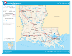
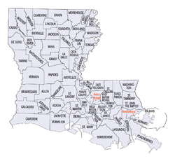
The following outline is provided as an overview of and topical guide to the U.S. state of Louisiana:
Louisiana – U.S. state located in the southern region of the United States of America. Louisiana is the only state in the U.S. with political subdivisions termed parishes, which are local governments equivalent to counties. Some Louisiana urban environments have a strong multicultural and multilingual heritage, influenced by an admixture of 18th century French, Spanish, Native American (Indian) and African inhabitants.
History of Louisiana |
---|
United Statesportal |
Louisiana is a state in the Deep South and South Central regions of the United States. It is bordered by the state of Texas to the west, Arkansas to the north, Mississippi to the east, and the Gulf of Mexico to the south; a large part of its eastern boundary is demarcated by the Mississippi River. Of the 50 U.S. states, it ranks 20th in land area and the 25th in population, with roughly 4.6 million residents. Reflecting its French heritage, Louisiana is the only U.S. state with political subdivisions termed parishes, which are equivalent to counties, making it one of only two U.S. states not subdivided into counties. The state's capital is Baton Rouge, and its largest city is New Orleans, with a population of roughly 383,000 people.
West Florida was a region on the northern coast of the Gulf of Mexico that underwent several boundary and sovereignty changes during its history. As its name suggests, it was formed out of the western part of former Spanish Florida, along with lands taken from French Louisiana; Pensacola became West Florida's capital. The colony included about two thirds of what is now the Florida Panhandle, as well as parts of the modern U.S. states of Louisiana, Mississippi, and Alabama.
The Territory of Orleans or Orleans Territory was an organized incorporated territory of the United States that existed from October 1, 1804, until April 30, 1812, when it was admitted to the Union as the State of Louisiana.
The territory of the United States and its overseas possessions has evolved over time, from the colonial era to the present day. It includes formally organized territories, proposed and failed states, unrecognized breakaway states, international and interstate purchases, cessions, and land grants, and historical military departments and administrative districts. The last section lists informal regions from American vernacular geography known by popular nicknames and linked by geographical, cultural, or economic similarities, some of which are still in use today.
The Florida Parishes, on the east side of the Mississippi River—an area also known as the Northshore or Northlake region—are eight parishes in the southeastern portion of the U.S. state of Louisiana.
The term French Louisiana refers to two distinct regions:
The following is an alphabetical list of articles related to the U.S. state of Louisiana.
The following outline is provided as an overview of and topical guide to the U.S. state of Arkansas:
The following outline is provided as an overview of and topical guide to the U.S. state of Iowa.
The following outline is provided as an overview of and topical guide to the U.S. state of Kansas:
The following outline is provided as an overview of and topical guide to the U.S. state of Minnesota:
The following outline is provided as an overview of and topical guide to the U.S. state of Missouri:
The following outline is provided as an overview of and topical guide to the U.S. state of Nebraska:
The following outline is provided as an overview of and topical guide to the U.S. state of North Dakota:
The following outline is provided as an overview of and topical guide to the U.S. state of Oklahoma:
The following outline is provided as an overview of and topical guide to the U.S. state of Wyoming:
The area currently occupied by the U.S. State of New Mexico has undergone numerous changes in occupancy and territorial claims and designations. This geographic chronology traces the territorial evolution of New Mexico.
The Mobile Act was the popular name of a bill signed into law in early 1804 by United States President Thomas Jefferson. The law defined revenue boundaries for the newly acquired territories that the United States had gained from its purchase of La Louisiane from France. The act anticipated that Mobile would be designated as a port of entry for a new revenue district. Mobile was, however, at the time a part of the Spanish province of West Florida.