Vidalia, Louisiana

Last updated

Vidalia, Louisiana
City of Vidalia
Mississippi River bridge at Vidalia, LA IMG 6916.JPG
Flag of Vidalia, Louisiana.svg
Motto: 
City on the Move
Concordia Parish Louisiana Incorporated and Unincorporated areas Vidalia Highlighted.svg
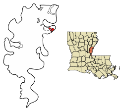
Location of Vidalia in Concordia Parish, Louisiana.
USA Louisiana location map.svg
Red pog.svg
Vidalia
Coordinates: 31°33′55″N91°25′33″W / 31.56528°N 91.42583°W / 31.56528; -91.42583
CountryFlag of the United States.svg  United States
States Louisiana
Parish Concordia
Incorporated (town)1870
Incorporated (city)2012
Government
  Type Mayor-council government
  BodyCity council
  MayorEdwy Gene "Buz" Craft (D)

Unseated Hyram Copeland, March 5, 2016

Police Chief "Joey" Merrill (No Party)
Area
[1]
  Total2.59 sq mi (6.72 km2)
  Land2.59 sq mi (6.72 km2)
  Water0.00 sq mi (0.00 km2)
Elevation
65 ft (20 m)
Population
 (2020)
  Total4,027
  Density1,552.43/sq mi (599.36/km2)
ZIP code
71373
Website cityofvidaliala.com

Vidalia is the largest city and the parish seat of Concordia Parish, Louisiana, United States. [2] The population was 4,299 as of the 2010 census. [3]

Contents

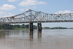
Vidalia is located on the west bank of the Mississippi River.

The city of Natchez, Mississippi, lies on the opposite bank of the river, connected by the Natchez–Vidalia Bridge, carrying U.S. Routes 65, 84, and 425.

History

Vidalia was founded by Don José Vidal, when he was secretary to Manuel Gayoso de Lemos, the Spanish Governor of the Natchez District from 1792 to 1797. This was in a brief period of Spanish rule of former French territory west of the Mississippi River. Napoleon took it back and he sold it to the United States in the Louisiana Purchase of 1803.

In 1811 the Orleans Territorial legislature changed the name of the city to Vidalia after the founder. Vidal had donated land along the river to the city, where it later constructed its civic buildings. He also donated land for the first school in Concordia Parish.

The Great Sandbar Duel, featuring Jim Bowie, was a formal one-on-one duel that erupted into a violent brawl involving multiple combatants on September 19, 1827. It is a regional legend still told by local residents.

Vidalia is home to Louisiana's first hydroelectric power plant and the largest prefabricated power plant in the world. A total of 41 countries and 21 states collaborated in this historic endeavor, the Sidney A. Murray, Jr. Hydroelectric Station, located in the southern portion of Concordia Parish. The power plant began operation in 1990. The office is located on Texas Street in town.

Hyram Copeland, a Democrat, was repeatedly re-elected; he served as mayor of Vidalia from 1992 to 2016. He is a 2013 inductee of the Louisiana Political Museum and Hall of Fame. [4]

Geography

According to the United States Census Bureau, the city has a total area of 2.6 square miles (6.7 km2), all land. [3]

Demographics

Historical population
CensusPop.Note
1880 449
1890 82182.9%
1900 1,02224.5%
1910 1,34531.6%
1920 1,246−7.4%
1930 1,141−8.4%
1940 1,31815.5%
1950 1,64124.5%
1960 4,313162.8%
1970 5,53828.4%
1980 5,9367.2%
1990 4,953−16.6%
2000 4,543−8.3%
2010 4,299−5.4%
2020 4,027−6.3%
U.S. Decennial Census [5]

2020 census

Vidalia racial composition [6]
RaceNumberPercentage
White (non-Hispanic)2,72467.64%
Black or African American (non-Hispanic)1,02825.53%
Native American 70.17%
Asian 481.19%
Other/Mixed 801.99%
Hispanic or Latino 1403.48%

As of the 2020 United States census, there were 4,027 people, 1,480 households, and 948 families residing in the town.

2010 census

As of the census [7] of 2010, there were 4,299 people, 1,707 households, and 1,186 families residing in the town. The population density was 1,959.7 inhabitants per square mile (756.6/km2). There were 1,910 housing units at an average density of 823.9 per square mile (318.1/km2). The racial makeup of the town was 72.0% White, 26.2% African American, 0.2% Native American, 0.4% Asian, 0.4% from other races, and 0.7% from two or more races. Hispanic or Latino of any race were 1.5% of the population.

There were 1,779 households, out of which 33.4% had children under the age of 18 living with them, 51.5% were married couples living together, 16.5% had a female householder with no husband present, and 27.5% were non-families. 25.4% of all households were made up of individuals, and 11.7% had someone living alone who was 65 years of age or older. The average household size was 2.55 and the average family size was 3.07.

In the town, the population was spread out, with 27.4% under the age of 18, 8.1% from 18 to 24, 26.4% from 25 to 44, 23.0% from 45 to 64, and 15.1% who were 65 years of age or older. The median age was 38 years. For every 100 females, there were 91.2 males. For every 100 females age 18 and over, there were 86.4 males.

The median income for a household in the town was $29,500, and the median income for a family was $36,917. Males had a median income of $31,667 versus $21,455 for females. The per capita income for the town was $14,478. About 17.8% of families and 19.1% of the population were below the poverty line, including 25.2% of those under age 18 and 13.5% of those age 65 or over.

Arts and culture

Sites of interest

The Tacony Plantation in Vidalia is listed on the National Register of Historic Places. [8]

Vidalia Landing Riverfront Park has landscaped green space, a hotel, convention and conference center; amphitheater; and health facilities: ambulatory care center and acute care facility; a walking/biking trail, and public boat ramps.[ citation needed ]

With the city's purchase of 70+ acres, Concordia Recreation District #3 constructed a Sports Complex. Municipal Park is also home to the newly constructed City Hall, Police Station, and Fire Department. In addition to municipal services and sports, the park accommodates the Dr. William T. Polk City Park and the Vidalia Community Garden.[ citation needed ]

Related Research Articles

<span class="mw-page-title-main">Attala County, Mississippi</span> County in Mississippi, United States

Attala County is a county located in the U.S. state of Mississippi. As of the 2020 census, the population was 17,889. Its county seat is Kosciusko. Attala County is named for Atala, a fictional Native American heroine from an early-19th-century novel of the same name by François-René de Chateaubriand.

<span class="mw-page-title-main">West Feliciana Parish, Louisiana</span> Parish in Louisiana, United States

West Feliciana Parish is a civil parish located in the U.S. state of Louisiana. At the 2020 census, the population was 15,310. The parish seat is St. Francisville. The parish was established in 1824.

<span class="mw-page-title-main">Concordia Parish, Louisiana</span> Parish in Louisiana, United States

Concordia Parish borders the Mississippi River in eastern central Louisiana. As of the 2020 census, the population was 18,687. The parish seat is Vidalia. The parish was formed in 1807.

<span class="mw-page-title-main">Oil City, Louisiana</span> Town in Louisiana, United States

Oil City is a town in Caddo Parish, Louisiana. The population was 1,008 at the time of the 2010 census. Oil City is located on Louisiana Highway 1, north of Caddo Lake. It is part of the Shreveport–Bossier City Metropolitan Statistical Area.

<span class="mw-page-title-main">Harrisonburg, Louisiana</span> Village in Louisiana, United States

Harrisonburg is a village in and the parish seat of Catahoula Parish, Louisiana, United States. The population was 348 as of the 2010 census, down from 746 in 2000.

<span class="mw-page-title-main">Sicily Island, Louisiana</span> Village in Louisiana, United States

Sicily Island is a village in Catahoula Parish, Louisiana, United States. The population was 336 at the 2020 census.

<span class="mw-page-title-main">Clayton, Louisiana</span> Town in Louisiana, United States

Clayton is a town in northern Concordia Parish, Louisiana, United States. The population was 711 at the 2010 census. Cotton is a principal commodity in the area. Clayton is located on the Tensas River, important for fishing and boating, promoted through a U.S. Army Corps of Engineers-maintained boat launch. The Tensas River merges with the Black River in Jonesville in Catahoula Parish.

<span class="mw-page-title-main">Ferriday, Louisiana</span> Sole incorporated city in Louisiana, United States

Ferriday is a town in Concordia Parish, which borders the Mississippi River and is located on the central eastern border of Louisiana, United States. With a population of 3,511 at the 2010 census, it is an African-American majority town.

<span class="mw-page-title-main">Ridgecrest, Louisiana</span> Town in Louisiana, United States

Ridgecrest is a small town in Concordia Parish, Louisiana, United States. The population was 694 at the 2010 census.

<span class="mw-page-title-main">Georgetown, Louisiana</span> Village in Louisiana, United States

Georgetown is a village in Grant Parish, Louisiana, United States. It is part of the Alexandria, Louisiana Metropolitan Statistical Area. The population was 327 at the 2010 census.

<span class="mw-page-title-main">White Castle, Louisiana</span> Town in Louisiana, United States

White Castle is a town in Iberville Parish, Louisiana, United States. At the 2010 U.S. census the town population was 1,883, and 1,640 at the 2020 population estimates program. It is part of the Baton Rouge metropolitan area.

<span class="mw-page-title-main">Springfield, Louisiana</span> Town in Louisiana, United States

Springfield is a town in Livingston Parish, Louisiana, United States. The population was 487 at the 2010 census. It is part of the Baton Rouge metropolitan statistical area.

<span class="mw-page-title-main">Delta, Louisiana</span> Village in Louisiana, United States

Delta is a village in Madison Parish, Louisiana, United States. The population was 232 at the 2020 census. It is part of the Tallulah Micropolitan Statistical Area.

<span class="mw-page-title-main">Natchez, Louisiana</span> Town in Louisiana, United States

Natchez is a town in Natchitoches Parish, Louisiana, United States. The population was 597 at the 2010 census. It is part of the Natchitoches Micropolitan Statistical Area. The village and parish are part of the Cane River National Heritage Area and located on Isle Brevelle.

<span class="mw-page-title-main">Gramercy, Louisiana</span> Town in Louisiana, United States

Gramercy is a town in the U.S. state of Louisiana, in St. James Parish. It is part of the New Orleans Metropolitan Area. The population was 3,613 at the time of the 2010 U.S. census and 3,188 according to the 2020 population estimates program.

<span class="mw-page-title-main">Lutcher, Louisiana</span> Town in Louisiana, United States

Lutcher is a town in St. James Parish, Louisiana, United States, on the east bank of the Mississippi River. It is part of the New Orleans Metropolitan Area. The population was 3,559 at the 2010 U.S. census, and 3,127 at the 2020 population estimates program.

<span class="mw-page-title-main">Waterproof, Louisiana</span> Village in Louisiana, United States

Waterproof is a village in Tensas Parish in northeastern Louisiana, United States with a population of 688 as of the 2010 census. The village in 2010 was 91.7 percent African American. Some 24 percent of Waterproof residents in 2010 were aged sixty or above.

<span class="mw-page-title-main">St. Francisville, Louisiana</span> Town in Louisiana, United States

St. Francisville is a town in and the parish seat of, West Feliciana Parish, Louisiana, United States. The population was 1,557 at the 2020 census. It is part of the Baton Rouge metropolitan statistical area.

<span class="mw-page-title-main">Natchez micropolitan area</span> Micropolitan statistical area in the United States

The Natchez Micropolitan Statistical Area is a micropolitan area that consists of Adams County, Mississippi and Concordia Parish, Louisiana. As of the 2000 census, it had a population of 54,587.

Minorca is an unincorporated community and census-designated place (CDP) in Concordia Parish, Louisiana, United States. As of the 2010 census it had a population of 2,317. It is located in northeastern Concordia Parish, bordered on the east by the city of Vidalia.

References

  1. "2020 U.S. Gazetteer Files". United States Census Bureau. Retrieved March 20, 2022.
  2. "Find a County". National Association of Counties. Retrieved June 7, 2011.
  3. 1 2 "Geographic Identifiers: 2010 Demographic Profile Data (G001): Vidalia town, Louisiana". U.S. Census Bureau, American Factfinder. Archived from the original on February 12, 2020. Retrieved August 20, 2014.
  4. "Mayor Hyram Copeland". concordiaed.com. Retrieved October 19, 2013.
  5. "Census of Population and Housing". Census.gov. Retrieved June 4, 2015.
  6. "Explore Census Data". data.census.gov. Retrieved December 29, 2021.
  7. "U.S. Census website". United States Census Bureau . Retrieved January 31, 2008.
  8. "Tacony Plantation House". National Park Service. Retrieved July 18, 2016.