A ZIP Code is a postal code used by the United States Postal Service (USPS) in a system it introduced in 1963. The term ZIP is an acronym for Zone Improvement Plan; it was chosen to suggest that the mail travels more efficiently and quickly when senders use the code in the postal address. The basic format consists of five digits. An extended ZIP+4 code was introduced in 1983 which includes the five digits of the ZIP Code, followed by a hyphen and four additional digits that reference a more specific location.

Coulter is an unincorporated community in South Versailles Township, Allegheny County, Pennsylvania, United States. The community is located along the Youghiogheny River 14.3 miles (23.0 km) southeast of Pittsburgh. Coulter has a post office with ZIP code 15028, which opened on April 11, 1864.

Marchand is an unincorporated community in Indiana County, Pennsylvania, United States. The community is located on U.S. Route 119 6.2 miles (10.0 km) north of Marion Center. Marchand had a post office until it closed on April 23, 2005; it still has its own ZIP code, 15758.

Batchelor is an unincorporated community in Pointe Coupee Parish, Louisiana, United States. The community is located at the intersection of Louisiana highways 1 and 419 near the south bank of the Mississippi River, 8 miles (13 km) north-northwest of Morganza. Batchelor has a post office with ZIP code 70715, which opened on July 26, 1902.
Paulina is an unincorporated community and census-designated place in St. James Parish, Louisiana, United States. Its population was 1,178 as of the 2010 census. The community is located on the east bank of the Mississippi River in the eastern part of the parish, west of Lutcher and across the river from Vacherie. Paulina has a post office with ZIP code 70763.
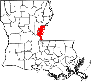
Fairbanks is an unincorporated community in Ouachita Parish, Louisiana, United States. The community is located along Louisiana Highway 134 near U.S. Route 165, 10.5 miles (16.9 km) north-northeast of downtown Monroe. Fairbanks has a post office with ZIP code 71240.
Jones is an unincorporated community in Morehouse Parish, Louisiana, United States. The community is located along U.S. Route 165, 3.7 miles (6.0 km) north-northeast of Bonita. Jones has a post office with ZIP code 71250.
Sondheimer is an unincorporated community in East Carroll Parish, Louisiana, United States. The community is located on U.S. Route 65, 17.5 miles (28.2 km) south of Lake Providence. Sondheimer has a post office with ZIP code 71276.
Rhinehart is an unincorporated community in La Salle and Catahoula parishes, Louisiana, United States. The community is located on Louisiana Highway 8, 8.1 miles (13.0 km) east-southeast of Jena. Rhinehart has a post office with ZIP code 71363.
Ruby is an unincorporated community in Rapides Parish, Louisiana, United States. The community is located on Louisiana Highway 454, 14.3 miles (23.0 km) southeast of Alexandria. Ruby had a post office from April 18, 1900, until October 8, 2011; it still has its own ZIP code, 71365.
Trout is an unincorporated community in La Salle Parish, Louisiana, United States. The community is located on U.S. Route 84, 2.8 miles (4.5 km) west of Jena. Trout has a post office with ZIP code 71371.
Elmer is an unincorporated community in Rapides Parish, Louisiana, United States. The community is located on Louisiana Highway 112, 18.6 miles (29.9 km) southwest of Alexandria. Elmer has a post office with ZIP code 71424, which opened on May 15, 1888.
Enterprise is an unincorporated community in Catahoula Parish, Louisiana, United States. The community is located along the south bank of the Ouachita River and Louisiana Highway 124, 9.7 miles (15.6 km) north-northwest of Harrisonburg. Enterprise had a post office until it closed on October 15, 2011; it still has its own ZIP code, 71425.
Gorum is an unincorporated community in Natchitoches Parish, Louisiana, United States. The community is located on Louisiana Highway 119, 24 miles (39 km) south-southeast of Natchitoches. Gorum has a post office with ZIP code 71434, which opened on November 21, 1890.

Lakemont is an unincorporated community in Rabun County, Georgia, United States, located in a mountainous area between U.S. Route 23/441 and Lake Rabun. Lakemont has a post office with ZIP code 30552.
Rabun Gap is an unincorporated community in Rabun County, Georgia, United States. The community is located along U.S. Route 23/441 south of Dillard. Rabun Gap has a post office with ZIP code 30568.
Marsteller is an unincorporated community in Cambria County, Pennsylvania, United States. The community is 1.5 miles (2.4 km) west of Northern Cambria. Marsteller had its own post office until April 23, 2005; it still has its own ZIP code, 15760.
Torrance is an unincorporated community in Derry Township, Westmoreland County, Pennsylvania, United States. The community is located on the south side of the Conemaugh River 2.2 miles (3.5 km) east of Blairsville. Torrance has a post office with ZIP code 15779.
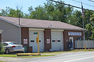
Jones Mills is an unincorporated community in Westmoreland County, Pennsylvania, United States. The community is located along Pennsylvania Routes 31 and 381 2.8 miles (4.5 km) east-southeast of Donegal. Jones Mills has a post office with ZIP code 15646, which opened on May 23, 1850.
Wood is an unincorporated community in the U.S. state of Pennsylvania; portions of the community lie in Bedford, Fulton, and Hundington counties. The community is 2.4 miles (3.9 km) south of Broad Top City. Wood has a post office with ZIP code 16694, which opened on September 9, 1908.