The Mississippi River is the primary river, and second-longest river, of the largest drainage basin in the United States. From its traditional source of Lake Itasca in northern Minnesota, it flows generally south for 2,340 miles (3,766 km) to the Mississippi River Delta in the Gulf of Mexico. With its many tributaries, the Mississippi's watershed drains all or parts of 32 U.S. states and two Canadian provinces between the Rocky and Appalachian mountains. The main stem is entirely within the United States; the total drainage basin is 1,151,000 sq mi (2,980,000 km2), of which only about one percent is in Canada. The Mississippi ranks as the thirteenth-largest river by discharge in the world. The river either borders or passes through the states of Minnesota, Wisconsin, Iowa, Illinois, Missouri, Kentucky, Tennessee, Arkansas, Mississippi, and Louisiana.

Concordia Parish borders the Mississippi River in eastern central Louisiana. As of the 2020 census, the population was 18,687. The parish seat is Vidalia. The parish was formed in 1807.

Morganza is an incorporated village near the Mississippi River in Pointe Coupee Parish, Louisiana, United States. The population was 610 at the 2010 census, down from 659 in 2000. As of 2020 the population was 525. It is part of the Baton Rouge metropolitan statistical area. The village's zip code is 70759. The Morganza Spillway, a flood control structure between the Mississippi River and the Atchafalaya Basin, is located nearby.

Poydras is a census-designated place (CDP) in St. Bernard Parish, Louisiana, United States. The population was 3,886 at the 2000 census and 2,536 in 2020. It is part of the New Orleans–Metairie–Kenner Metropolitan Statistical Area. Poydras is on the East Bank of the Mississippi River, just upriver from the Plaquemines Parish line.

LaPlace is a census-designated place (CDP) in St. John the Baptist Parish, Louisiana, United States, situated along the east bank of the Mississippi River, in the New Orleans metropolitan area. In 2020, it had a population of 28,841.
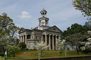
Vicksburg is a historic city in Warren County, Mississippi, United States. It is the county seat and has a population as of 2020 of 21,573. Located on a high bluff on the east bank of the Mississippi River across from Louisiana, Vicksburg was built by French colonists in 1719. The outpost withstood an attack from the native Natchez people. It was incorporated as Vicksburg in 1825 after Methodist missionary Newitt Vick. The area that is now Vicksburg was long occupied by the Natchez Native Americans as part of their historical territory along the Mississippi. The first Europeans who settled the area were French colonists who built Fort Saint Pierre in 1719 on the high bluffs overlooking the Yazoo River at present-day Redwood. They conducted fur trading with the Natchez and others, and started plantations. During the American Civil War, it was a key Confederate river-port, and its July 1863 surrender to Ulysses S. Grant, along with the concurrent Battle of Gettysburg, marked the turning-point of the war. The city is home to three large installations of the United States Army Corps of Engineers, which has often been involved in local flood control. After the war came Reconstruction and then a violent return to power by white supremacists and the Democrat Party in 1874 and 1875. Vicksburg's population is majority African American.
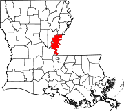
St. Charles Parish is a parish located in the U.S. state of Louisiana. At the 2020 census, its population was 52,549. The parish seat is Hahnville and the most populous community is Luling.

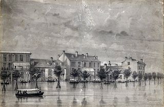
The Great Mississippi Flood of 1927 was the most destructive river flood in the history of the United States, with 27,000 square miles (70,000 km2) inundated in depths of up to 30 feet (9 m) over the course of several months in early 1927. The period cost of the damage has been estimated to be between $246 million and $1 billion, which ranges from $4.2–$17.3 billion in 2023 dollars.

The Bonnet Carré Spillway is a flood control operation in the Lower Mississippi Valley. Located in St. Charles Parish, Louisiana, about 12 miles (19 km) west of New Orleans, it allows floodwaters from the Mississippi River to flow into Lake Pontchartrain and thence into the Gulf of Mexico. The spillway was constructed between 1929 and 1931, following the Great Mississippi Flood of 1927, and has been designated as a National Historic Civil Engineering Landmark by the American Society of Civil Engineers.

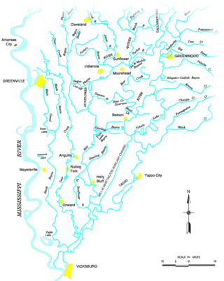
The Atchafalaya Basin, or Atchafalaya Swamp, is the largest wetland and swamp in the United States. Located in south central Louisiana, it is a combination of wetlands and river delta area where the Atchafalaya River and the Gulf of Mexico converge. The river stretches from near Simmesport in the north through parts of eight parishes to the Morgan City southern area.
Sauvé's Crevasse was a Mississippi River levee failure in May 1849 that resulted in flooding much of New Orleans, Louisiana.
Elliot City is a ghost town that was located in Pointe Coupee Parish's 10th Ward, approximately 6 miles west of Livonia, Louisiana United States. The site of the town itself is located at coordinates 30.555942, -91.662475, and is covered or partially covered by the current U.S. Route 190 roadway.

Mississippi is a state in the Southeastern region of the United States, bordered to the north by Tennessee; to the east by Alabama; to the south by the Gulf of Mexico; to the southwest by Louisiana; and to the northwest by Arkansas. Mississippi's western boundary is largely defined by the Mississippi River, or its historical course. Mississippi is the 32nd largest by area and 35th-most populous of the 50 U.S. states and has the lowest per-capita income in the United States. Jackson is both the state's capital and largest city. Greater Jackson is the state's most populous metropolitan area, with a population of 591,978 in 2020.
The Flood Control Act of 1928 authorized the United States Army Corps of Engineers to design and construct projects for the control of floods on the Mississippi River and its tributaries as well as the Sacramento River in California. It was sponsored by Senator Wesley L. Jones (R) of Washington and Representative Frank R. Reid (R) of Illinois, in response to the Great Mississippi Flood of 1927.
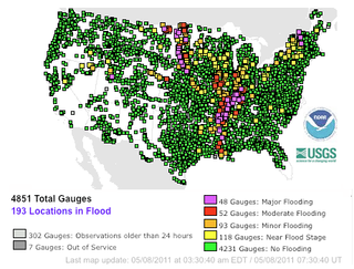
Major floods along the Mississippi River in April and May 2011 were among the largest and most damaging recorded along the U.S. waterway in the past century, comparable in extent to the Great Mississippi Flood of 1927 and Great Flood of 1993. In April 2011, two large storm systems deposited record levels of rainfall on the Mississippi River drainage basin. When that additional water combined with the springtime snowmelt, the river and many of its tributaries began to swell to record levels by the beginning of May. Flooding occurred in Illinois, Missouri, Kentucky, Tennessee, Arkansas, Mississippi, and Louisiana.

The Birds Point-New Madrid Floodway is a flood control component of the Mississippi River and Tributaries Project located on the west bank of the Mississippi River in southeast Missouri just below the confluence of the Ohio and Mississippi Rivers. The construction of the floodway was authorized by the Flood Control Act of 1928 and later modified by the Flood Control Act of 1965. Its purpose is to divert water from the Mississippi River during major flood events and lower the flood stages upstream, notably at Cairo, Illinois.

Flooding in the Mississippi River Basin during the winter, spring, and summer of 2019 caused at least 12 deaths and economic losses in 19 states totaling in excess of $20 billion. Estimated damages in the Midwestern United States alone had reached $12.5 billion by April 2019. Flood damages totaling $6.2 billion were reported in the 11 states bordering the Mississippi River. In addition to property and crop losses and infrastructure damages, commercial navigation on the Mississippi River was interrupted repeatedly by high currents, low bridge clearances, and closed locks. This delayed shipments of agricultural commodities, adding to the economic stress of crop losses caused by flooding. As of late April 2019, shipments of corn to export terminals in Louisiana were 31% lower than in same period in 2018.
The Duckport Canal was an unsuccessful military venture by Union forces during the Vicksburg campaign of the American Civil War. Ordered built in late March 1863 by Major General Ulysses S. Grant, the canal stretched from the Mississippi River near Duckport, Louisiana, to New Carthage, Louisiana, and utilized a series of swampy bayous for much of its path. It was intended to provide a water-based supply route for a southward movement against the Confederate-held city of Vicksburg, Mississippi, as high water levels made overland travel difficult. Manual digging was provided by 3,500 soldiers from Grant's army and was finished on April 12. The next day, the levee separating the canal cut and the Mississippi River was breached, and water flowed into the canal. Trees that had grown up in the bayous and falling water levels that reached as shallow as 6 inches (15 cm) at one point hampered the use of the canal, and the project was abandoned on May 4. Grant moved men and supplies through the overland route, which had been made more accessible by the same falling water levels that doomed the canal. After some inland maneuvering and a lengthy siege, Vicksburg surrendered on July 4, marking a significant turning point in the war.