Related Research Articles

Interstate 49 (I-49) is a north–south Interstate Highway with multiple segments. The original portion is entirely within Louisiana with an additional signed portion extending from I-220 in Shreveport to the Arkansas state line, three newer sections are in Arkansas, and one section in Missouri. Its southern terminus is in Lafayette, Louisiana, at I-10 while its northern terminus is in Kansas City, Missouri, at I-435 and I-470. Future plans include portions of the remaining roadway in Louisiana, Arkansas, and Texas, to link Kansas City, Missouri with New Orleans.
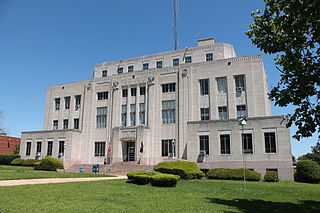
Miller County is a county located in the southwestern corner of the U.S. state of Arkansas. As of the 2020 census, the population was 42,600. The county seat is Texarkana.

Lafayette County is a county located in the U.S. state of Arkansas. As of the 2020 census, the population was 6,308, making it the third-least populous county in Arkansas. The county seat is Lewisville. Lafayette County was formed on October 15, 1827, and named in honor of the Marquis de Lafayette, a French military hero of the American Revolutionary War. It is a dry county; therefore, the sale of alcohol is prohibited.

Columbia County is a county located in the U.S. state of Arkansas. As of the 2020 census, the population was 22,801. The county seat is Magnolia. The county was formed on December 17, 1852, and was named for Christopher Columbus. The Magnolia, AR Micropolitan Statistical Area includes all of Columbia County.
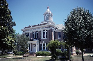
Cleveland County is a county located in the U.S. state of Arkansas. Its population was 7,550 at the 2020 U.S. census. The county seat and largest city is Rison. Cleveland County is included in the Pine Bluff, AR Metropolitan Statistical Area, which is also included in the Little Rock-North Little Rock, AR Combined Statistical Area.

Fouke is a city in Miller County, Arkansas, United States. It is part of the Texarkana, Texas - Texarkana, Arkansas Metropolitan Statistical Area. The population was 810 in 2024

Garland, also known as Garland City, is a town in Miller County, Arkansas, United States. It is part of the Texarkana, Texas - Texarkana, Arkansas Metropolitan Statistical Area. The population was 195 at the 2020 census, down from 242 in 2010.

U.S. Route 71 or U.S. Highway 71 is a major north–south United States highway that extends for over 1500 miles (2500 km) in the central United States. This original 1926 route has remained largely unchanged by encroaching Interstate highways. Currently, the highway's northern terminus is in International Falls, Minnesota at the Canada–US border, at the southern end of the Fort Frances-International Falls International Bridge to Fort Frances, Ontario. U.S. Route 53 also ends here. On the other side of the bridge, Trans-Canada Highway is an east–west route while Ontario Highway 71 is a north–south route. US 71's southern terminus is between Port Barre and Krotz Springs, Louisiana at an intersection with U.S. Route 190. For the entirety south of Kansas City, Missouri, US 71 runs parallel and concurrent with the existing and future Interstate 49. North of Kansas City, US 71 runs halfway between Interstate 29 and Interstate 35, which they split in the city at an interchange with Interstate 70.
In Arkansas folklore, the Fouke Monster, also known as the Boggy Creek Monster and the Swamp Stalker, is purported to be a humanoid creature, similar to descriptions of Bigfoot, that was allegedly sighted in the rural town of Fouke, Arkansas during the early 1970s. The creature was alleged to have attacked a local family. It has since become a part of Arkansas folklore. Stories of the creature influenced the 1972 docudrama horror film The Legend of Boggy Creek, which became the 11th highest-grossing film of 1972 and is today considered to be a cult classic.

The Texarkana metropolitan statistical area (MSA), as defined by the United States Office of Management and Budget, is a two-county region anchored by the twin cities of Texarkana, Texas and Texarkana, Arkansas, and encompassing surrounding communities in Bowie County, Texas, and Miller County, Arkansas. As of the 2016 census, the MSA had a population of 150,098. Texarkana is a subset of the broader Ark-La-Tex region.
Genoa is an unincorporated community and census-designated place (CDP) in Miller County, Arkansas, United States. It was first listed as a CDP in the 2020 census with a population of 972. It is located 6 to 12 miles east of Texarkana along Highway 196. Although unincorporated, Genoa has a post office, with the ZIP code of 71840 for a specific post office box. Most of the community is served by ZIP code 71854 (Texarkana). Genoa also has its own school district, Genoa Central School District.

Interstate 49 (I-49) is an Interstate Highway in the state of Arkansas. There are two main sections of the highway across different sides of the state. The southern section starts at the Louisiana state line, then runs to Texarkana, at the Texas state line. The northern section begins at I-40 and at U.S. Highway 71 (US 71) in Alma and runs north to the Missouri state line, where the freeway continues into Missouri. An additional small section south of Fort Smith is currently designated as Highway 549 until it is extended northward to the I-40 interchange, at which point it will become part of I-49.
Bivins is an unincorporated community and census designated place (CDP) in eastern Cass County, Texas, United States. It lies along State Highway 43, east of the city of Linden, the county seat of Cass County. Its elevation is 318 feet (97 m), and it is located at 33°1′10″N94°11′57″W. Although Bivins is unincorporated, it has a post office, with the ZIP code of 75555.
Jessieville is an unincorporated community located in Garland County, Arkansas, United States. It is located next to Hot Springs Village and north of Hot Springs. Highway 7 runs through the community, and Highway 298 is also inside the town. The town has one school campus, which contains an elementary school, a middle school and a high school.
Crocketts Bluff is an unincorporated community in Arkansas County, Arkansas, United States. It is the location of Crocketts Bluff Hunting Lodge, which is located at the end of the dirt road north of the point at which AR 153 turns south, and is listed on the National Register of Historic Places. Crocketts Bluff sits at an elevation of 171 feet the highest point in Arkansas County. The ZIP Code for Crocketts Bluff is 72038.
Casscoe is an unincorporated community in Arkansas County, Arkansas, United States. The community is located where Arkansas Highway 33 Spur diverges from Arkansas Highway 33.
Fouke School District 15 is a public school district based in Fouke, Miller County, Arkansas, United States. The district serves more than 1,100 students in prekindergarten through grade 12 and employs more than 150 faculty and staff at its three schools and district offices.
Three States is an unincorporated community in Caddo Parish, Louisiana, Miller County, Arkansas, and Cass County, Texas, United States. The community is at the point where three states meet: Texas, Arkansas, and Louisiana. In 2000, the population was 45. The Louisiana side of Three States is part of the Shreveport – Bossier City metropolitan area, while the Arkansas side is part of the Texarkana metropolitan area.
U.S. Route 71 is a U.S. route that runs from Krotz Springs, LA to the Fort Frances–International Falls International Bridge at the Canadian border. In Arkansas, the highway runs from the Louisiana state line near Doddridge to the Missouri state line near Bella Vista. In Texarkana, the highway runs along State Line Avenue with US 59 and partially runs in Texas. Other areas served by the highway include Fort Smith and Northwest Arkansas.
Bright Star School District was a school district headquartered in the Bright Star School in Doddridge, Arkansas.
References
- ↑ U.S. Geological Survey Geographic Names Information System: Doddridge, Arkansas
- ↑ Zip Code Lookup Archived June 15, 2011, at the Wayback Machine
- ↑ Home. Bright Star School District. October 20, 2001. Retrieved on May 14, 2018. "Rt. 1 Box 222 Doddridge, AR 71834"
- ↑ "Consolidation/Annexations of LEA's (1983-2010) [usurped] ." () Arkansas Department of Education. Retrieved on March 6, 2011.
Municipalities and communities of Miller County, Arkansas, United States | ||
|---|---|---|
| Cities |  | |
| Town | ||
| CDP | ||
| Other unincorporated communities | ||
33°05′30″N93°54′30″W / 33.09167°N 93.90833°W
| | This article about a location in Miller County, Arkansas is a stub. You can help Wikipedia by expanding it. |