Garland, Arkansas

Last updated

Garland, Arkansas
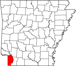
Miller County Arkansas Incorporated and Unincorporated areas Garland Highlighted 0525780.svg
Location in Miller County, Arkansas
Coordinates: 33°21′44″N93°42′54″W / 33.36222°N 93.71500°W / 33.36222; -93.71500
Country United States
State Arkansas
County Miller
Area
[1]
  Total0.88 sq mi (2.27 km2)
  Land0.88 sq mi (2.27 km2)
  Water0.00 sq mi (0.00 km2)
Elevation
226 ft (69 m)
Population
 (2020) [2]
  Total195
  Density222.35/sq mi (85.86/km2)
Time zone UTC-6 (Central (CST))
  Summer (DST) UTC-5 (CDT)
ZIP Code
71839
FIPS code 05-25780
GNIS feature ID0076999

Garland, also known as Garland City, [3] is a town [4] in Miller County, Arkansas, United States. It is part of the Texarkana, Texas - Texarkana, Arkansas Metropolitan Statistical Area. The population was 195 at the 2020 census, [2] down from 242 in 2010.

Contents

Geography

Garland is located in eastern Miller County at 33°21′44″N93°42′54″W / 33.36222°N 93.71500°W / 33.36222; -93.71500 (33.362268, -93.715081), [5] on the west bank of the Red River. Via U.S. Route 82 it is 22 miles (35 km) east of Texarkana and 31 miles (50 km) west of Magnolia.

According to the United States Census Bureau, the town has a total area of 0.9 square miles (2.3 km2), all land. [1]

Demographics

Historical population
CensusPop.Note
1910 277
1920 37033.6%
1930 42514.9%
1940 325−23.5%
1950 3518.0%
1960 3777.4%
1970 321−14.9%
1980 660105.6%
1990 415−37.1%
2000 352−15.2%
2010 242−31.2%
2020 195−19.4%
U.S. Decennial Census [6]

2020 census

Garland racial composition [7]
RaceNumberPercentage
White (non-Hispanic)4422.56%
Black or African American (non-Hispanic)14272.82%
Other/Mixed 42.05%
Hispanic or Latino 52.56%

As of the 2020 United States census, there were 195 people, 133 households, and 95 families residing in the town.

2000 census

As of the census [8] of 2000, there were 352 people, 133 households, and 88 families residing in the town. The population density was 165.7/km2 (428.6/mi2). There were 164 housing units at an average density of 77.2/km2 (199.7/mi2). The racial makeup of the town was 27.84% White, 69.89% Black or African American, 0.28% Native American, 0.28% Asian, and 1.70% from two or more races. 0.57% of the population were Hispanic or Latino of any race.

There were 133 households, out of which 25.6% had children under the age of 18 living with them, 35.3% were married couples living together, 23.3% had a female householder with no husband present, and 33.1% were non-families. 29.3% of all households were made up of individuals, and 13.5% had someone living alone who was 65 years of age or older. The average household size was 2.65 and the average family size was 3.24.

In the town, the population was spread out, with 25.6% under the age of 18, 9.1% from 18 to 24, 25.0% from 25 to 44, 26.4% from 45 to 64, and 13.9% who were 65 years of age or older. The median age was 38 years. For every 100 females, there were 92.3 males. For every 100 females age 18 and over, there were 87.1 males.

The median income for a household in the town was $17,500, and the median income for a family was $20,625. Males had a median income of $24,375 versus $15,000 for females. The per capita income for the town was $9,292. About 37.6% of families and 44.7% of the population were below the poverty line, including 62.5% of those under age 18 and 38.9% of those age 65 or over.

Infrastructure

Highways

Garland has a small airstrip on the south side of the town that is mostly used by crop dusters.

Education

Lafayette County School District operates public schools. On July 1, 1990, the Garland School District consolidated into the Lewisville School District. On July 1, 2003, the Lewisville district consolidated with the Stamps School District to form the Lafayette County district. [9]

Notable people

Related Research Articles

<span class="mw-page-title-main">Big Flat, Arkansas</span> Town in Arkansas, United States

Big Flat is a town in Baxter and Searcy counties in the U.S. state of Arkansas. The population was 88 at the 2020 census.

<span class="mw-page-title-main">Everton, Arkansas</span> Town in Arkansas, United States

Everton is a town in Boone County, Arkansas, United States. The population was 133 at the 2010 census. It is part of the Harrison Micropolitan Statistical Area.

<span class="mw-page-title-main">South Lead Hill, Arkansas</span> Town in Arkansas, United States

South Lead Hill is a town in Boone County, Arkansas, United States. The population was 102 at the 2010 census. It is part of the Harrison Micropolitan Statistical Area.

<span class="mw-page-title-main">Banks, Arkansas</span> Town in Arkansas, United States

Banks is a town in Bradley County, Arkansas, United States. As of the 2010 census the population was 124.

<span class="mw-page-title-main">Caddo Valley, Arkansas</span> Town in Arkansas, United States

Caddo Valley is a town in Clark County, Arkansas, United States. The population was 635 at the 2010 census.

<span class="mw-page-title-main">Emerson, Arkansas</span> Town in Arkansas, United States

Emerson is a town in Columbia County, Arkansas, United States. The population was 368 at the 2010 census.

<span class="mw-page-title-main">Caraway, Arkansas</span> City in Arkansas, United States

Caraway is a city in Craighead County, Arkansas, United States. The population was 1,279 at the 2010 census. It is included in the Jonesboro, Arkansas Metropolitan Statistical Area.

<span class="mw-page-title-main">Cash, Arkansas</span> City in Arkansas, United States

Cash is a city in western Craighead County, Arkansas, United States. The population was 342 at the 2010 census. Cash Arkansas population was of mostly white with 99.8% and partial Puerto Rican ethnicity. It is included in the Jonesboro, Arkansas Metropolitan Statistical Area.

<span class="mw-page-title-main">Tollette, Arkansas</span> Town in Arkansas, United States

Tollette is a town in southern Howard County, Arkansas, United States. The population was 240 at the 2010 census, down from 324 in 2000.

<span class="mw-page-title-main">Pleasant Plains, Arkansas</span> Town in Arkansas, United States

Pleasant Plains is a town in Independence County, Arkansas, United States. The population was 349 at the 2010 census, up from 267 in 2000.

<span class="mw-page-title-main">Lewisville, Arkansas</span> City in Arkansas, United States

Lewisville is a city in Lafayette County, Arkansas, United States. The population was 1,280 at the 2010 census. It is the county seat of Lafayette County.

<span class="mw-page-title-main">Luxora, Arkansas</span> City in Arkansas, United States

Luxora is a city in Mississippi County, Arkansas, United States. The population was 942 at the 2020 census, down from 1,178 in 2010.

<span class="mw-page-title-main">Bodcaw, Arkansas</span> Town in Arkansas, United States

Bodcaw is a town in Nevada County, Arkansas, United States. The population was 121 at the 2020 census. It is part of the Hope Micropolitan Statistical Area.

<span class="mw-page-title-main">Cale, Arkansas</span> Town in Arkansas, United States

Cale is a town in Nevada County, Arkansas, United States. The population was 75 at the 2000 census. It is part of the Hope Micropolitan Statistical Area.

<span class="mw-page-title-main">Reader, Arkansas</span> Census-designated place in Arkansas, United States

Reader is an unincorporated census-designated place in Nevada and Ouachita counties in the U.S. state of Arkansas. As of the 2010 census, its population is 66. Per the 2020 census, the population was 40.

<span class="mw-page-title-main">Rosston, Arkansas</span> Town in Arkansas, United States

Rosston is a town in south-central Nevada County, Arkansas, United States. The population was 265 at the 2000 census. It is part of the Hope Micropolitan Statistical Area.

<span class="mw-page-title-main">Willisville, Arkansas</span> Town in Arkansas, United States

Willisville is a town in Nevada County, Arkansas, United States. The population was 148 at the 2020 census. It is part of the Hope Micropolitan Statistical Area.

<span class="mw-page-title-main">Daisy, Arkansas</span> Town in Arkansas, United States

Daisy is a town in Pike County, Arkansas, United States. Its population is 88 as of the 2020 census. Daisy is also the home of Daisy State Park.

<span class="mw-page-title-main">Reyno, Arkansas</span> City in Arkansas, United States

Reyno is a city in Randolph County, Arkansas, United States. The population was 456 at the 2010 census.

<span class="mw-page-title-main">Midland, Arkansas</span> Town in Sebastian County, Arkansas, United States

Midland is a town in Sebastian County, Arkansas, United States. It is part of the Fort Smith, Arkansas-Oklahoma Metropolitan Statistical Area. The population was 325 at the 2010 census.

References

  1. 1 2 "2021 U.S. Gazetteer Files: Arkansas". United States Census Bureau. Retrieved June 2, 2022.
  2. 1 2 "P1. Race – Garland town, Arkansas: 2020 DEC Redistricting Data (PL 94-171)". U.S. Census Bureau. Retrieved June 2, 2022.
  3. highway signs on US 71 at AR 134 south of Fouke
  4. Local.Arkansas.gov - Garland , retrieved September 3, 2012
  5. "US Gazetteer files: 2010, 2000, and 1990". United States Census Bureau. February 12, 2011. Retrieved April 23, 2011.
  6. "Census of Population and Housing". Census.gov. Retrieved June 4, 2015.
  7. "Explore Census Data". data.census.gov. Retrieved December 30, 2021.
  8. "U.S. Census website". United States Census Bureau . Retrieved January 31, 2008.
  9. "ConsolidationAnnex_from_1983.xls Archived 2015-09-12 at the Wayback Machine ." Arkansas Department of Education. Retrieved on October 13, 2017.