Saint-Joseph, Martinique

Last updated
Saint-Joseph
Saint-Joseph 972.PNG
Location of the commune (in red) within Martinique
Location of Saint-Joseph
Saint-Joseph, Martinique
Coordinates: 14°40′15″N61°02′15″W / 14.6708°N 61.0375°W / 14.6708; -61.0375 Coordinates: 14°40′15″N61°02′15″W / 14.6708°N 61.0375°W / 14.6708; -61.0375
Country France
Overseas region and department Martinique
Arrondissement Fort-de-France
Intercommunality CA Centre de la Martinique
Government
  Mayor (20202026) Yan Monplaisir [1]
Area
1
43.29 km2 (16.71 sq mi)
Population
 (Jan. 2019) [2]
15,883
  Density370/km2 (950/sq mi)
Time zone UTC−04:00 (AST)
INSEE/Postal code
97224 /97212
Elevation20–762 m (66–2,500 ft)
1 French Land Register data, which excludes lakes, ponds, glaciers > 1 km2 (0.386 sq mi or 247 acres) and river estuaries.

Saint-Joseph is a commune in the Arrondissement of Fort-de-France on Martinique.

Contents

Geography

Climate

Saint-Joseph has a tropical monsoon climate (Köppen climate classification Am). The average annual temperature in Saint-Joseph is 26.3 °C (79.3 °F). The average annual rainfall is 2,404.2 mm (94.65 in) with November as the wettest month. The temperatures are highest on average in August, at around 27.3 °C (81.1 °F), and lowest in February, at around 24.9 °C (76.8 °F). The highest temperature ever recorded in Saint-Joseph was 34.9 °C (94.8 °F) on 20 September 2005; the coldest temperature ever recorded was 15.2 °C (59.4 °F) on 12 January 1979.

Climate data for Saint-Joseph (1991–2020 averages, extremes 1976−present)
MonthJanFebMarAprMayJunJulAugSepOctNovDecYear
Record high °C (°F)30.2
(86.4)
32.5
(90.5)
32.9
(91.2)
33.1
(91.6)
33.3
(91.9)
32.7
(90.9)
32.2
(90.0)
34.7
(94.5)
34.9
(94.8)
33.6
(92.5)
32.6
(90.7)
31.9
(89.4)
34.9
(94.8)
Average high °C (°F)28.1
(82.6)
28.2
(82.8)
28.6
(83.5)
29.2
(84.6)
29.8
(85.6)
29.9
(85.8)
29.9
(85.8)
30.5
(86.9)
30.9
(87.6)
30.5
(86.9)
29.6
(85.3)
28.7
(83.7)
29.5
(85.1)
Daily mean °C (°F)25.0
(77.0)
24.9
(76.8)
25.2
(77.4)
25.9
(78.6)
26.7
(80.1)
27.1
(80.8)
27.1
(80.8)
27.3
(81.1)
27.2
(81.0)
26.9
(80.4)
26.3
(79.3)
25.5
(77.9)
26.3
(79.3)
Average low °C (°F)21.8
(71.2)
21.6
(70.9)
21.8
(71.2)
22.6
(72.7)
23.6
(74.5)
24.4
(75.9)
24.3
(75.7)
24.1
(75.4)
23.5
(74.3)
23.3
(73.9)
23.0
(73.4)
22.3
(72.1)
23.0
(73.4)
Record low °C (°F)15.2
(59.4)
15.5
(59.9)
15.6
(60.1)
16.0
(60.8)
19.0
(66.2)
20.0
(68.0)
20.0
(68.0)
18.0
(64.4)
19.3
(66.7)
19.0
(66.2)
19.0
(66.2)
16.0
(60.8)
15.2
(59.4)
Average precipitation mm (inches)141.7
(5.58)
95.9
(3.78)
103.5
(4.07)
172.8
(6.80)
169.8
(6.69)
190.6
(7.50)
237.0
(9.33)
275.8
(10.86)
255.1
(10.04)
298.0
(11.73)
288.5
(11.36)
175.5
(6.91)
2,404.2
(94.65)
Average precipitation days (≥ 1.0 mm)20.416.415.615.716.319.222.322.120.121.822.119.8231.6
Source: Météo-France [3]

Population

Historical population
YearPop.±% p.a.
1967 10,923    
1974 10,950+0.04%
1982 11,266+0.36%
1990 14,036+2.79%
1999 15,785+1.31%
2007 17,215+1.09%
2012 16,648−0.67%
2017 16,232−0.50%
Source: INSEE [4]

See also

Related Research Articles

<span class="mw-page-title-main">Saint-Louis, Réunion</span> Commune in Réunion, France

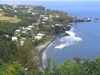
Saint-Louis is the fifth-largest commune in the French overseas department of Réunion. It is located on the southwest part of the island of Réunion, adjacent to Saint-Pierre.

Saint-Véran Commune in Provence-Alpes-Côte dAzur, France

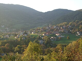
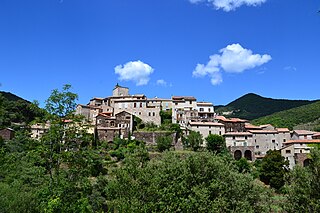
Saint-Véran is a commune in the Hautes-Alpes department in southeastern France in the Queyras Regional Natural Park.

Bénonces Commune in Auvergne-Rhône-Alpes, France

Bénonces is a commune in the Ain department in eastern France.

Saint-Nicolas-lès-Cîteaux Commune in Bourgogne-Franche-Comté, France

Saint-Nicolas-lès-Cîteaux is a commune in the Côte-d'Or department in eastern France.

<span class="mw-page-title-main">Saint-Benoît, Réunion</span> Subprefecture and commune in Réunion, France

Saint-Benoît is a commune in the French overseas department of Réunion. It is located on the eastern part of the island of Réunion, about 40 kilometres southeast of Saint-Denis, the capital.

<span class="mw-page-title-main">Saint-Joseph, Réunion</span> Commune in Réunion, France

Saint-Joseph is a commune in the French overseas department of Réunion. It is located on the extreme south end of the island of Réunion. As such, it features the southernmost point of the European Union. The village Vincendo is part of the commune.

<span class="mw-page-title-main">Petite-Île</span> Commune in Réunion, France

Petite-Île is a commune on the French island and department of Réunion. The commune is bordered by the communes of Saint-Joseph to the east and Saint-Pierre to the west. The commune gets its name from the uninhabited islet off of its coast, the only such islet near Réunion that has vegetation. The commune was established in 1935.

<span class="mw-page-title-main">Saint-Philippe</span> Commune in Réunion, France

Saint-Philippe is a commune in the French overseas department of Réunion. It is located in south-eastern Reunion.

<span class="mw-page-title-main">Montmélian</span> Commune in Auvergne-Rhône-Alpes, France

Montmélian is a commune in the Savoie department in the Auvergne-Rhône-Alpes region in south-eastern France. Montmélian station has rail connections to Grenoble, Modane, Bourg-Saint-Maurice and Chambéry.

<span class="mw-page-title-main">Saint-Julien-de-Peyrolas</span> Commune in Occitania, France

Saint-Julien-de-Peyrolas is a commune in the Gard department in southern France.

<span class="mw-page-title-main">Saint-Sauveur-Camprieu</span> Commune in Occitania, France

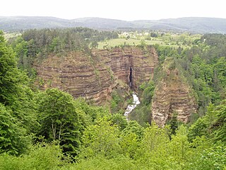
Saint-Sauveur-Camprieu is a commune in the Gard department in southern France.

<span class="mw-page-title-main">Saint-Martial, Gard</span> Commune in Occitania, France

Saint-Martial is a commune in the Gard department in southern France.

<span class="mw-page-title-main">Basse-Pointe</span> Commune in Martinique, France

Basse-Pointe is a town and commune in the French overseas department and region, and island of Martinique.

<span class="mw-page-title-main">Le Morne-Rouge</span> Commune in Martinique, France

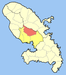
Le Morne-Rouge is a commune and town in the French overseas department and island of Martinique.

<span class="mw-page-title-main">L'Ajoupa-Bouillon</span> Commune in Martinique, France

L'Ajoupa-Bouillon, commonly known as L'Ajoupa, is a commune and town in the French overseas department and region, and island, of Martinique.

<span class="mw-page-title-main">Macouba</span> Commune in Martinique, France

Macouba is a village and commune in the French overseas department of Martinique.

<span class="mw-page-title-main">Le François</span> Commune in Martinique, France

Le François is a town and commune in the arrondissement of Le Marin on Martinique, 22 km (14 mi) from the island capital of Fort-de-France.

Sainte-Anne, Martinique Commune in Martinique, France

Sainte-Anne is a village and commune in the French overseas department of Martinique.

<span class="mw-page-title-main">Fonds-Saint-Denis</span> Commune in Martinique, France

Fonds-Saint-Denis is a village and commune in the French overseas department and region, and island, of Martinique. It is the smallest commune of the island.

Saint-Drézéry Commune in Occitania, France

Saint-Drézéry is a commune in the Hérault department in the Occitanie region in southern France.

References

  1. "Répertoire national des élus: les maires". data.gouv.fr, Plateforme ouverte des données publiques françaises (in French). 2 December 2020.
  2. "Populations légales 2019". The National Institute of Statistics and Economic Studies. 29 December 2021.
  3. "Fiche Climatologique Statistiques 1991-2020 et records" (PDF) (in French). Météo-France . Retrieved September 6, 2022.
  4. Population en historique depuis 1968, INSEE