
The War of 1812 was fought by the United States of America and its indigenous allies against the United Kingdom and its own indigenous allies in British North America, with limited participation by Spain in Florida. It began when the United States declared war on 18 June 1812. Although peace terms were agreed upon in the December 1814 Treaty of Ghent, the war did not officially end until the peace treaty was ratified by Congress on 17 February 1815.

Oliver Hazard Perry was an American naval commander, born in South Kingstown, Rhode Island. A prominent member of the Perry family naval dynasty, he was the son of Sarah Wallace Alexander and United States Navy Captain Christopher Raymond Perry, and older brother of Commodore Matthew C. Perry.

Charles County is located in Southern Maryland. As of the 2020 census, the population was 166,617. The county seat is La Plata. The county was named for Charles Calvert (1637–1715), third Baron Baltimore. Charles County is part of the Washington metropolitan area and the Southern Maryland region.

St. Simons Island is a barrier island and census-designated place (CDP) located on St. Simons Island in Glynn County, Georgia, United States. The names of the community and the island are interchangeable, known simply as "St. Simons Island" or "SSI", or locally as "The Island". St. Simons is part of the Brunswick metropolitan statistical area, and according to the 2020 U.S. census, the CDP had a population of 14,982.

Solomons, also known as Solomons Island, is an unincorporated community and census-designated place (CDP) in Calvert County, Maryland, United States. The population was 2,368 at the 2010 census, up from 1,536 in 2000. Solomons is a popular weekend destination spot in the Baltimore–Washington metropolitan area.
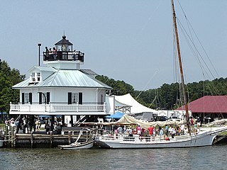
Saint Michaels, also known as St. Michaels, is a town in Talbot County, Maryland, United States. The population was 1,029 at the 2010 census. Saint Michaels derives its name from the Episcopal Parish established there in 1677. The church attracted settlers who engaged in tobacco growing and ship building.
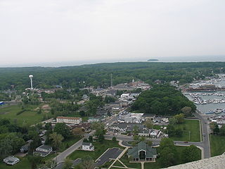
Put-in-Bay is a resort village located on South Bass Island in Put-in-Bay Township, Ottawa County, Ohio, United States, 35 miles (56 km) east of Toledo. The population was 154 at the 2020 census.

The Battle of Long Island, also known as the Battle of Brooklyn and the Battle of Brooklyn Heights, was an action of the American Revolutionary War fought on August 27, 1776, at the western edge of Long Island in present-day Brooklyn. The British defeated the Continental Army and gained access to the strategically important Port of New York, which they held for the rest of the war. It was the first major battle to take place after the United States declared its independence on July 4, 1776, in Philadelphia. It was the largest battle of the Revolutionary War in terms of both troop deployment and combat.
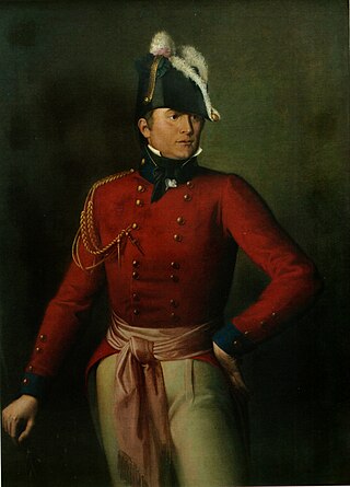
Major-General Robert Ross was an Irish officer in the British Army who served in the Napoleonic Wars and its theatre in North America in the War of 1812.

The Battle of Baltimore was a sea/land battle fought between British and American forces in the War of 1812. American forces repulsed sea and land invasions off the busy port city of Baltimore, Maryland, and killed the commander of the invading British forces. The British and Americans first met at the Battle of North Point. Though the Americans retreated, the battle was a successful delaying action that inflicted heavy casualties on the British, halted their advance, and consequently allowed the defenders at Baltimore to prepare for an attack properly.

Joshua Barney was an American Navy officer who served in the Continental Navy during the Revolutionary War and as a captain in the French Navy during the French Revolutionary Wars. He later achieved the rank of commodore in the United States Navy and also served in the War of 1812.

The Battle of Bladensburg was a battle of the Chesapeake Campaign during the War of 1812, fought on 24 August 1814, at Bladensburg, Maryland, 8.6 miles (13.8 km) northeast of Washington, D.C.

The Battle of Craney Island was a victory for the United States during the War of 1812. The battle saved the city of Norfolk, and the adjacent city of Portsmouth, from British invasion. Especially important to Virginia and northeastern North Carolina, the region was a major hub for American commerce.

The Battle of St. Michaels was an engagement contested on August 10, 1813, during the War of 1812. British soldiers attacked the American militia at St. Michaels, Maryland, which is located on Maryland's Eastern Shore with access to Chesapeake Bay. At the time, this small town was on the main shipping route to important cities such as Baltimore and Washington, D.C.

The history of the United States Marine Corps (USMC) begins with the founding of the Continental Marines on 10 November 1775 to conduct ship-to-ship fighting, provide shipboard security and discipline enforcement, and assist in landing forces. Its mission evolved with changing military doctrine and foreign policy of the United States. Owing to the availability of Marine forces at sea, the United States Marine Corps has served in nearly every conflict in United States history. It attained prominence when its theories and practice of amphibious warfare proved prescient, and ultimately formed a cornerstone of U.S. strategy in the Pacific Theater of World War II. By the early 20th century, the Marine Corps would become one of the dominant theorists and practitioners of amphibious warfare. Its ability to rapidly respond on short notice to expeditionary crises has made and continues to make it an important tool for U.S. foreign policy.

The South West Pacific theatre, during World War II, was a major theatre of the war between the Allies and the Axis. It included the Philippines, the Dutch East Indies, Borneo, Australia and its mandate Territory of New Guinea and the western part of the Solomon Islands. This area was defined by the Allied powers' South West Pacific Area (SWPA) command.
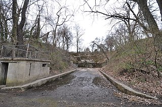
Fort Howard was a military installation located on the North Point peninsula, overlooking the main channel of the Patapsco River leading into the harbor of Baltimore, Maryland, USA. Although militarily important since the early 19th century, its surviving elements and name date to the Spanish–American War. It was named by Elihu Root, Secretary of War under President Theodore Roosevelt, in 1902 after Colonel John Eager Howard (1752–1827). The installation earned the nickname the "Bulldog at Baltimore's Gate", serving as the coastal artillery headquarters for Baltimore, Maryland. Fort Howard's historical significance is its military connection with the War of 1812, the Spanish–American War, and World War II.
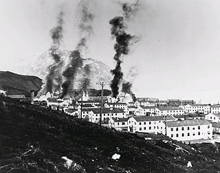
The Battle of Dutch Harbor took place on June 3–4, 1942, when the Imperial Japanese Navy launched two aircraft carrier raids on the Dutch Harbor Naval Operating Base and U.S. Army Fort Mears at Dutch Harbor on Amaknak Island, during the Aleutian Islands Campaign of World War II. The bombing marked the first aerial attack by an enemy on the continental United States, and was the second time in history that the continental U.S. was bombed by someone working for a foreign power, the first being the accidental bombing of Naco, Arizona in 1929.
Brigadier General Rezin Beall (1723–1809) was appointed commander of Maryland's Flying Camp militia by the United States Congress.

The Second Battle of St. Michaels was a raid conducted on Maryland's Eastern Shore by British soldiers during the War of 1812. The raid occurred on August 26, 1813, at points between Tilghman Island and the town of St. Michaels, Maryland. Local militia defended against the raiders.


