Clements, Maryland

Last updated

Clements is an unincorporated community in St. Mary's County, Maryland, United States. [1] Clements is located in Northern St. Mary's County Maryland. ZIP Code 20624—Area Code 301—Time Zone Eastern—Population 1,282.

Unincorporated area Region of land not governed by own local government

In law, an unincorporated area is a region of land that is not governed by a local municipal corporation; similarly an unincorporated community is a settlement that is not governed by its own local municipal corporation, but rather is administered as part of larger administrative divisions, such as a township, parish, borough, county, city, canton, state, province or country. Occasionally, municipalities dissolve or disincorporate, which may happen if they become fiscally insolvent, and services become the responsibility of a higher administration. Widespread unincorporated communities and areas are a distinguishing feature of the United States and Canada. In most other countries of the world, there are either no unincorporated areas at all, or these are very rare; typically remote, outlying, sparsely populated or uninhabited areas.
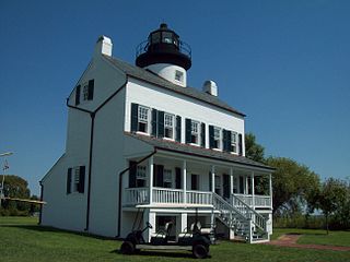
St. Marys County, Maryland County in the United States

Saint Mary's County, established in 1637, is a county located in the U.S. state of Maryland. As of the 2010 census, the population was 105,151. Its county seat is Leonardtown. The name is in honor of the Catholic saint Mary, the mother of Jesus as told in the Bible.

Maryland State of the United States of America

Maryland is a state in the Mid-Atlantic region of the United States, bordering Virginia, West Virginia, and the District of Columbia to its south and west; Pennsylvania to its north; and Delaware to its east. The state's largest city is Baltimore, and its capital is Annapolis. Among its occasional nicknames are Old Line State, the Free State, and the Chesapeake Bay State. It is named after the English queen Henrietta Maria, known in England as Queen Mary.

The community derives its name from Saint Clement parish on the island of Jersey. [2]

Saint Clement, Jersey Jersey parish

Saint Clement is one of the twelve parishes of Jersey in the Channel Islands. It is in the south east of the Island, and contains some of the suburbs of Saint Helier. It is the smallest parish by surface area, but the second most densely populated. St. Clement stretches west to east from Le Dicq to within a quarter mile of La Rocque harbour. Its surface area is around 1,044 acres (4.22 km2).

Jersey British Crown Dependency in the Channel Islands

Jersey, officially the Bailiwick of Jersey, is a Crown dependency located near the coast of Normandy, France. Jersey was part of the Duchy of Normandy, whose dukes went on to become kings of England from 1066. After Normandy was lost by the kings of England in the 13th century, and the ducal title surrendered to France, Jersey and the other Channel Islands remained attached to the English crown.

Related Research Articles

Beauvue is an unincorporated community in St. Mary's County, Maryland, United States. Mulberry Fields was listed on the National Register of Historic Places in 1973.

Coltons Point, Maryland human settlement in United States of America

Coltons Point is an unincorporated community in what is popularly called the "Seventh District" of St. Mary's County, Maryland, United States. Here are located a small historical museum, a lighthouse, and a Catholic devotional monument to the miraculous medal. Seasonal boat service at times carries visitors the short distance to the shrinking, uninhabited St. Clement's Island, where in 1634 the first European settlers arriving in Maryland landed and celebrated the first Catholic Mass in English-speaking North America. It was listed on the National Register of Historic Places in 1972.

Compton is an unincorporated community near Leonardtown in St. Mary's County, Maryland, United States. The St. Francis Xavier Church and Newtown Manor House Historic District was listed on the National Register of Historic Places in 1972.

Drayden is an unincorporated community in St. Mary's County, Maryland, United States. West St. Mary's Manor was listed on the National Register of Historic Places in 1970. Porto Bello was listed in 1972.

Oakley is an unincorporated community in St. Mary's County, Maryland, United States. The River View was listed on the National Register of Historic Places in 1976.

Oakville is an unincorporated community in St. Mary's County, Maryland, United States. Sandgates On Cat Creek was listed on the National Register of Historic Places in 1978. The area was the scene of the murder of Stephanie Roper.

Callaway is an unincorporated community in St. Mary's County, Maryland, United States. The elevation is 105 feet (32 m).

Abell is an unincorporated community in what is familiarly called the "Seventh District" of St. Mary's County, Maryland, United States. Abell was a brewing ground for many fisherman and farmers in the late 19th century until around the late 1950s. Abell was known for its many major ports, and for its deep water access which made it easy for large steam boats to maneuver. Many of the ports have been demolished due to storms and hurricanes. Today, some local fisherman still reside in the same area where they were raised. Abell is also known for its century old homes and views of the St. Clements Bay.

Loveville is an unincorporated community in St. Mary's County, Maryland, United States, named for A. Kingsley Love, an attorney. It is known for its Old Order Mennonite community who have a farmers' market/produce auction here, as well as craft shops and an annual quilt auction. Traditions of Loveville, an interior design and furniture store, occupies the Old Loveville Post Office Building. A Maryland Motor Vehicle Administration office is also here. The postal code for Loveville is 20656

Maddox is an unincorporated community in St. Mary's County, Maryland, United States.

Helen is an unincorporated community in St. Mary's County, Maryland, United States and near Mechanicsville. It was the hometown of French Forrest.

Tall Timbers is an unincorporated community and census-designated place in St. Mary's County, Maryland, United States.

Beachville-St. Inigoes is an unincorporated community in St. Mary's County, Maryland, United States. Located here is Webster Field, a branch of the larger Patuxent River Naval Air Station.

Hopewell is an unincorporated community in St. Mary's County, Maryland, United States. It lies at an elevation of 7 feet.

Waterford Village, California Unincorporated community in California, United States

Waterford Village is an unincorporated community in El Dorado County, California. It lies at an elevation of 669 feet.

Park Hall Estates is an unincorporated community in St. Mary's County, Maryland, United States.

Avenue, Maryland human settlement in United States of America

Avenue is an unincorporated community in what is familiarly called the "Seventh District" of St. Mary's County, Maryland, United States.

Carpenters Island was an island located at the head of St. Clement's Bay in St. Mary's County, Maryland, patented in 1847 to Susan E. Carpenter, Amanda Carpenter, Rebecca Carpenter, and Matilda Carpenter and certified in the name of William Carpenter. The land patented included surrounding waters and measured one and three quarter acres. In 2005, the island was included in a list of "lost islands" of Chesapeake Bay, which is situated between Maryland and Virginia in the United States.

Town Creek is a tributary of the Patuxent River in Saint Mary's County, Maryland.

Heron Island is a sandbar located in the Potomac River east-north-east of Saint Clement's Island in St. Mary's County, Maryland. The closest town is Colton's Point, Maryland, 1/2 mile to the north. The island is named for the large numbers of herons seen by the European colonists when they arrived in 1634.

References

  1. U.S. Geological Survey Geographic Names Information System: Clements, Maryland
  2. Kenny, Hamill (1984). The Placenames of Maryland : their origin and meaning. Baltimore, Md.: Maryland Historical Society. p. 64. ISBN   0-938420-28-3.

Coordinates: 38°19′34″N76°43′38″W / 38.32611°N 76.72722°W / 38.32611; -76.72722

Geographic coordinate system Coordinate system

A geographic coordinate system is a coordinate system that enables every location on Earth to be specified by a set of numbers, letters or symbols. The coordinates are often chosen such that one of the numbers represents a vertical position and two or three of the numbers represent a horizontal position; alternatively, a geographic position may be expressed in a combined three-dimensional Cartesian vector. A common choice of coordinates is latitude, longitude and elevation. To specify a location on a plane requires a map projection.