Related Research Articles
St. Mary's County, established in 1637, is a county located in the U.S. state of Maryland. As of the 2020 census, the population was 113,777. Its county seat is Leonardtown. The name is in honor of Mary, the mother of Jesus. St. Mary's County comprises the California-Lexington Park, Maryland Metropolitan Statistical Area, which also is included in the Washington-Baltimore-Arlington, DC-MD-VA-WV-PA Combined Statistical Area. It is part of the Southern Maryland region. The county was the home to the first Maryland Colony, and the first capital of the Colony of Maryland. Settled by English Catholics, it is considered to be the birthplace of religious freedom in North America, at a time when the British colonies were settled primarily by Protestants. The county is home to the Patuxent River Naval Air Station and St. Mary's College of Maryland. Traditionally, St. Mary's County has been known for its unique and historic culture of Chesapeake Bay tidewater farming, fishing, and crabbing communities. But with the advent of the military bases, growth of an extensive defense contractor presence, and the growth of St. Mary's College of Maryland, as well as increasing numbers of long-distance Washington, D.C. commuters, it has been undergoing a decades-long transformation which has seen the county's population double since 1970. The county is part of the Southern Maryland region of the state.
Fort Meade is a census-designated place (CDP) in Anne Arundel County, Maryland, United States. The population was 9,327 at the 2010 census. It is the home to the National Security Agency, Central Security Service, United States Cyber Command and the Defense Information Systems Agency, which are located on the U.S. Army post Fort George G. Meade.

Odenton is a census-designated place (CDP) in Anne Arundel County, Maryland, United States, located approximately 10–20 minutes from the state capital, Annapolis. The population was 37,132 at the 2010 census, up from 20,534 at the 2000 census. The town's population growth rate of 80.8% between 2000 and 2010 was the greatest of any town in western Anne Arundel County. Odenton is located west of Annapolis, south of Baltimore, and northeast of Washington, D.C..

Lusby is an unincorporated community and census-designated place (CDP) in Calvert County, Maryland, United States. The population of the CDP was 1,835 at the 2010 census. Residents of the Chesapeake Ranch Estates and Drum Point communities also use the Lusby ZIP code designation.

Upper Marlboro, officially the Town of Upper Marlboro, is the county seat of Prince George's County, Maryland, United States. As of the 2020 census, the population within the town limits was 652, although Greater Upper Marlboro, which covers a large area outside the town limits, is many times larger.

Lexington Park is a census-designated place (CDP) in St. Mary's County, Maryland, United States, and the principal community of the Lexington Park, Maryland Micropolitan Statistical Area. The population was 11,626 at the 2010 census.
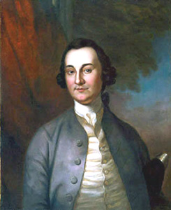
George Plater III was an American planter, lawyer, and statesman from Saint Mary's County, Maryland. He represented Maryland in the Continental Congress from 1778 to 1780, and briefly served as the sixth Governor of Maryland in 1791 and 1792.

Socks was the pet cat of the Clinton family, the first family of the United States from 1993 to 2001. An adopted stray, he was the pet of the Clintons during the early years of the administration, and his likeness hosted the children's version of the White House website, alongside the Clintons' dog, Buddy. After President Clinton left office, Socks resided with former Clinton secretary Betty Currie and her husband, owing to continuing conflicts with Buddy.

Leonardtown High School is a comprehensive public high school in Leonardtown, Maryland, United States, for students in grades 9–12. It offers college preparatory programs and programs that prepare students for business and technical occupations. It serves the community in the central portion of St. Mary's County, Maryland, between the Potomac River and Patuxent River. The area is a mixture of rural and suburban communities. Many of the families are employed by NAS Patuxent River, government contractors, St. Mary's College of Maryland, St Mary's County government and others involved in the traditional agriculture and water related businesses.
Great Mills High School is a comprehensive public high school in Great Mills, Maryland, United States. It serves students in grades 9–12 in the mixed rural and suburban area at the confluence of the Potomac River, Patuxent River, and Chesapeake Bay. It belongs to the St. Mary's County Public Schools system, and is associated with two other county high schools: Leonardtown High School and Chopticon High School. The school is accredited by the Middle States Colleges and Secondary Schools and the Maryland State Department of Education.

St. Mary's County Public Schools is a school district that serves St. Mary's County, Maryland, USA, at the confluence of the Potomac River, Patuxent River, and Chesapeake Bay. The area is a mixture of rural and suburban communities. Many of the families are employed by NAS Patuxent River, government contractors, St. Mary's College of Maryland, county government, and others involved in the traditional agriculture and water-related businesses. It has an approximate enrollment of almost 17,000 students. SMCPS operates 18 elementary schools, 5 middle schools, 4 high schools, an Alternative Learning Center, and a Vocational Training Center, serving students in Grades Pre-K through 12th grade. The school system is overseen by the Maryland State Department of Education.
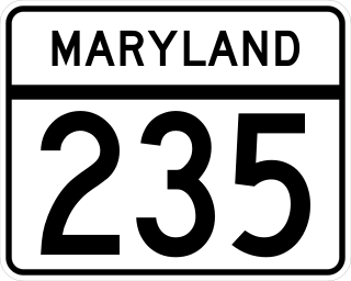
Maryland Route 235 (MD 235) is a state highway in the U.S. state of Maryland. Known as Three Notch Road, the state highway runs 30.63 miles (49.29 km) between its southern intersection with MD 5 in Ridge and its northern intersection with MD 5 near Mechanicsville. While the southern part of the state highway is a two-lane undivided rural road, the northern part of MD 235 is a four- to six-lane divided highway connecting Naval Air Station Patuxent River and the Washington, D.C., metro area in conjunction with MD 5. Three Notch Road has been the main highway between northern St. Mary's County and Point Lookout since the colonial era. The highway was reconstructed as the modern MD 235 between 1923 and 1938. The state highway was then completely rebuilt during World War II to serve the recently established NAS Patuxent River. Between 1960 and 1985, MD 235 was converted into a four-lane divided highway to the west and north of the military base. In the face of increasing activity at the base, the highway adjacent to NAS Patuxent River was expanded to six lanes in the early 2000s.
Fidelity Manor High School was a high school for African American children in Galena Park, Texas and a part of the Galena Park Independent School District (GPISD).
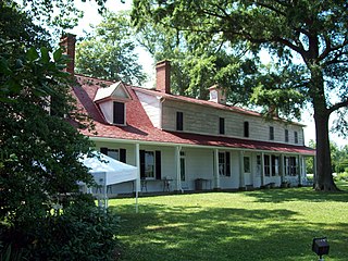
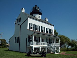
Sotterley Plantation is a historic landmark plantation house located at 44300 Sotterley Lane in Hollywood, St. Mary's County, Maryland, USA. It is a long 1+1⁄2-story, nine-bay frame building, covered with wide, beaded clapboard siding and wood shingle roof, overlooking the Patuxent River. Also on the property are a sawn-log slave quarters of c. 1830, an 18th-century brick warehouse, and an early-19th-century brick meat house. Farm buildings include an early-19th-century corn crib and an array of barns and work buildings from the early 20th century. Opened to the public in 1961, it was once the home of George Plater (1735–1792), the sixth Governor of Maryland, and Herbert L. Satterlee (1863–1947), a New York business lawyer and son-in-law of J.P. Morgan.

Shadingfield is a village and civil parish in the East Suffolk district of the English county of Suffolk. It is located around 4 miles (6.4 km) south of Beccles in the north of the county.

Aquasco is an unincorporated area and census-designated place in southeastern Prince George's County, Maryland, United States, surrounding the town of Eagle Harbor and bordering Charles County. As of the 2020 census, the CDP had a population of 913. Aquasco was home to the Aquasco Speedway.
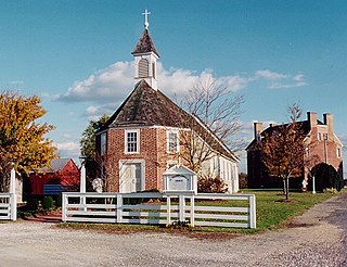
St. Francis Xavier Church and Newtown Manor House Historic District is the first county-designated historic district in Saint Mary's County, the "Mother County" of Maryland and is located in Compton, Maryland, near the county seat of Leonardtown. The district marks a location and site important in the 17th-century ecclesiastical history of Maryland, as an example of a self-contained Jesuit community made self-supporting by the surrounding 700-acre (2.8 km2) farm. The two principal historic structures were added to the National Register of Historic Places in 1972. Archaeological remains associated with the site date back to the early colonial period, mid-17th century.

Croom is an unincorporated community and census-designated place in Southern Prince George's County, Maryland, United States. As of the 2020 census it had a population of 2,720. Croom largely consists of former tobacco farms and forests converted to Washington bedroom subdivisions such as nearby Marlton. The main part of Patuxent River Park is in Croom.

Maryland Route 382 is a state highway in the U.S. state of Maryland. Known as Croom Road, the highway runs 15.34 miles (24.69 km) from the Charles–Prince George's county line near Aquasco north to U.S. Route 301 in Marlton. MD 382 connects Upper Marlboro with the southeastern corner of Prince George's County and northeastern Charles County. The highway formerly extended west from its southern terminus to Waldorf. MD 382 was built from what is now US 301 south through Croom between the mid-1920s and early 1930s. The highway was extended south and west through Charles County to near Waldorf in the mid-1950s. Part of the extension has been built in the late 1920s as part of MD 233, a parallel highway that extended east to the county line near Aquasco. MD 382 was truncated at the county line to achieve its present length in the late 1980s.
Mill Branch of the Patuxent River in Prince George's County, Maryland is part of the Upper Patuxent Watershed.
References
- ↑ U.S. Geological Survey Geographic Names Information System: Hollywood, Maryland
- ↑ "Hollywood Elementary School". Archived from the original on June 18, 2008. Retrieved July 6, 2008.
- ↑ "Socks still rocks", Southern Maryland Newspapers Online, June 6, 2008.
- ↑ "Socks, former Clinton cat, put to sleep". CNN. February 20, 2009. Retrieved May 23, 2010.
38°20′44″N76°34′09″W / 38.345426°N 76.569214°W
Municipalities and communities of St. Mary's County, Maryland, United States | ||
|---|---|---|
| Town |  | |
| CDPs | ||
| Other communities |
| |