Denton, Maryland

Last updated

Denton, Maryland
Town of Denton
Choptank River Denton MD.jpg
The Choptank River in July 2008
Flag of Denton, Maryland.png
Seal of Denton, Maryland.png
Motto: 
"The Garden of America" [1]
Caroline County Maryland Incorporated and Unincorporated areas Denton Highlighted.svg
Location in Caroline County and the U.S. state of Maryland
USA Maryland location map.svg
Red pog.svg
Denton
Location within the U.S. state of Maryland
Usa edcp location map.svg
Red pog.svg
Denton
Denton (the United States)
Coordinates: 38°53′2″N75°49′36″W / 38.88389°N 75.82667°W / 38.88389; -75.82667
CountryFlag of the United States.svg United States of America
State Flag of Maryland.svg  Maryland
County Flag of Caroline County, Maryland.svg Caroline
Founded1781
Incorporated 1802 [2]
Government
   Mayor Abigail McNinch
  Town Admin.Scott Getchell
Area
[3]
  Total5.35 sq mi (13.86 km2)
  Land5.27 sq mi (13.64 km2)
  Water0.09 sq mi (0.22 km2)
Elevation
43 ft (13 m)
Population
 (2020)
  Total4,848
  Density920.45/sq mi (355.35/km2)
Time zone UTC−5 (Eastern (EST))
  Summer (DST) UTC−4 (EDT)
ZIP code
21629
Area code 410
FIPS code 24-22725
GNIS feature ID0590087
Website www.DentonMaryland.com

Denton is a town in Caroline County, Maryland, United States. The population of Denton was 4,418 as of the 2010 United States Census, and it is the county seat of Caroline County. [4]

Contents

History

Denton was established in 1781. [5] It was first called Eden Town, for Sir Robert Eden, the last royal governor of Maryland, and over time Eden Town was shortened to Denton. [6] [7] The town was incorporated in 1802. [8]

The town benefited from trade shipped along the adjacent Choptank river. Shipyards along the river serviced smaller sail and steamships plying their trade on the river, with most traffic flowing down to the larger town of Cambridge. The Choptank was deep enough to pose a formidable barrier to enslaved people fleeing north to freedom. [9] Irish-American abolitionist Hugh Hazlett and a group of escaped slaves were detained near the town in 1858, with a plaque commemorating the event. [9]

The steamship trade began in 1840s and ended in the 1920s. Steamships carried passengers and goods from Denton to Cambridge and other communities on the Chesapeake. [10]

The Museum of Rural Life interprets the ag-based heritage of the town and surrounding area. A historic steamboat pier is preserved in the town. [9]

Geography

Denton is located at 38°53′2″N75°49′36″W / 38.88389°N 75.82667°W / 38.88389; -75.82667 (38.883853, -75.826556). [11]

According to the United States Census Bureau, the town has a total area of 5.50 square miles (14.24 km2), of which 5.28 square miles (13.68 km2) is land and 0.22 square miles (0.57 km2) is water. [12]

Climate

The climate in this area is characterized by hot, humid summers and generally mild to cool winters. According to the Köppen Climate Classification system, Denton has a humid subtropical climate, abbreviated "Cfa" on climate maps. [13]

Demographics

Historical population
CensusPop.Note
1870 431
1880 4698.8%
1890 64136.7%
1900 90040.4%
1910 1,48164.6%
1920 1,5706.0%
1930 1,6042.2%
1940 1,572−2.0%
1950 1,80614.9%
1960 1,9387.3%
1970 1,561−19.5%
1980 1,92723.4%
1990 2,97754.5%
2000 2,960−0.6%
2010 4,41849.3%
2020 4,8489.7%
U.S. Decennial Census [14]

2010 census

As of the census [15] of 2010, there were 4,418 people, 1,606 households, and 1,034 families living in the town. The population density was 836.7 inhabitants per square mile (323.1/km2). There were 1,791 housing units at an average density of 339.2 per square mile (131.0/km2). The racial makeup of the town was 71.8% White, 22.9% African American, 0.4% Native American, 0.6% Asian, 1.0% from other races, and 3.1% from two or more races. Hispanic or Latino of any race were 3.3% of the population.

There were 1,606 households, of which 38.6% had children under the age of 18 living with them, 40.7% were married couples living together, 18.7% had a female householder with no husband present, 4.9% had a male householder with no wife present, and 35.6% were non-families. 29.3% of all households were made up of individuals, and 13% had someone living alone who was 65 years of age or older. The average household size was 2.56 and the average family size was 3.17.

The median age in the town was 35.8 years. 26.6% of residents were under the age of 18; 8.2% were between the ages of 18 and 24; 27.1% were from 25 to 44; 23.1% were from 45 to 64; and 15.1% were 65 years of age or older. The gender makeup of the town was 46.7% male and 53.3% female.

2000 census

As of the census [16] of 2000, there were 2,960 people, 1,140 households, and 697 families living in the town. The population density was 1,205.0 inhabitants per square mile (465.3/km2). There were 1,264 housing units at an average density of 514.6 per square mile (198.7/km2). The racial makeup of the town was 71.66% White, 25.44% African American, 0.34% Native American, 0.37% Asian, 0.24% from other races, and 1.96% from two or more races. Hispanic or Latino of any race were 1.86% of the population.

There were 1,140 households, out of which 31.1% had children under the age of 18 living with them, 37.7% were married couples living together, 17.7% had a female householder with no husband present, and 38.8% were non-families. 33.5% of all households were made up of individuals, and 15.0% had someone living alone who was 65 years of age or older. The average household size was 2.29 and the average family size was 2.90.

In the town, the population was spread out, with 23.3% under the age of 18, 8.3% from 18 to 24, 26.8% from 25 to 44, 19.6% from 45 to 64, and 22.0% who were 65 years of age or older. The median age was 39 years. For every 100 females, there were 87.3 males. For every 100 females age 18 and over, there were 80.4 males.

The median income for a household in the town was $34,936, and the median income for a family was $42,583. Males had a median income of $27,475 versus $20,504 for females. The per capita income for the town was $18,631. About 6.6% of families and 8.1% of the population were below the poverty line, including 7.4% of those under age 18 and 7.6% of those age 65 or over.

Government

The Caroline County Courthouse in June 2012 CarolineCountyMDcourthouse.JPG
The Caroline County Courthouse in June 2012
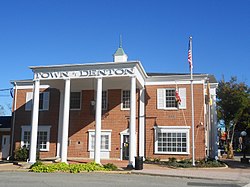
Town Hall Town Hall Denton MD.jpg
Town Hall

Media

Denton is home to WKDI radio (840 AM). It also is served by a weekly newspaper, the Times-Record, and a monthly magazine, the Caroline Review.

Infrastructure

Transportation

MD 313 southbound and MD 404 eastbound in Denton 2022-06-22 11 55 07 View south along Maryland State Route 313 and east along Maryland State Route 404 (Shore Highway) from the overpass for Camp Road in Denton, Caroline County, Maryland.jpg
MD 313 southbound and MD 404 eastbound in Denton

The town is served by Maryland Routes 404, 313, 328, 16, and 619. MD 404 bypasses Denton to the north and east and serves as the main route between the Chesapeake Bay Bridge to the west and the Delaware Beaches to the east. A business route, MD 404 Business, passes through the center of Denton. MD 313 follows MD 404 around the east side of Denton and runs north to Greensboro and south to Federalsburg. MD 328 begins at MD 404 in West Denton and heads southwest to Easton. MD 16 passes to the south of Denton and heads west to Preston and Cambridge and east along MD 404 toward the Delaware border. MD 619 heads from MD 404 Business in the center of Denton north to MD 313 and MD 404 on the northern part of the town. Denton borders the Choptank River. [17] Delmarva Community Transit provides bus service to Denton along multiple routes offering service to Easton, Federalsburg, Preston, and Greensboro. [18]

The American Discovery Trail runs through the town.

Utilities

Delmarva Power, a subsidiary of Exelon, provides electricity to Denton. [19] Chesapeake Utilities provides natural gas to the town. [20] Denton Public Works provides water and sewer service along with trash collection to the town. The town's public works department provides water service to about 1,600 customers and can handle over 1,000,000 gallons in a day. [21] The town operates the Denton Wastewater Treatment Plant, which has an average daily flow of 800,000 gallons and can handle a peak hourly flow of 2.67 million gallons. [22] Curbside trash collection is provided once a week to households in Denton. [23]

Notable people

Neighborhoods

Related Research Articles

<span class="mw-page-title-main">Caroline County, Maryland</span> County in Maryland, United States

Caroline County is a rural county located in the U.S. state of Maryland on its Eastern Shore. As of the 2020 census, the population was 33,293. Its county seat is Denton.

<span class="mw-page-title-main">Farmington, Delaware</span> Town in Delaware, United States

Farmington is a town in Kent County, Delaware, United States. It is part of the Dover, Delaware Metropolitan Statistical Area. The population was 92 in 2020.

<span class="mw-page-title-main">Felton, Delaware</span> Town in Delaware, United States

Felton is a town in Kent County, Delaware, United States. It is part of the Dover metropolitan statistical area. The population was 1,568 in 2020.

<span class="mw-page-title-main">Harrington, Delaware</span> City in Delaware, United States

Harrington is a city in Kent County, Delaware, United States. It is part of the Dover metropolitan statistical area. Harrington hosts the annual Delaware State Fair each July. The population was 3,774 in 2020.

<span class="mw-page-title-main">Hartly, Delaware</span> Town in Delaware, United States

Hartly is a town in Kent County, Delaware, United States. It is part of the Dover, Delaware Metropolitan Statistical Area. The population was 73 in 2020, making it the least populous municipality in Delaware.

<span class="mw-page-title-main">Kenton, Delaware</span> Town in Delaware, United States

Kenton is a town in Kent County, Delaware, United States. It is part of the Dover metropolitan statistical area. The population was 215 in 2020.

<span class="mw-page-title-main">Leipsic, Delaware</span> Town in Delaware, United States

Leipsic is a town in Kent County, Delaware, United States. It is part of the Dover, Delaware Metropolitan Statistical Area. The population was 178 in 2020.

<span class="mw-page-title-main">Viola, Delaware</span> Town in Delaware, United States

Viola is a town in Kent County, Delaware, United States. It is part of the Dover, Delaware Metropolitan Statistical Area. The population was 140 in 2020.

<span class="mw-page-title-main">Woodside, Delaware</span> Town in Delaware, United States

Woodside is a town in Kent County, Delaware, United States. It is part of the Dover, Delaware Metropolitan Statistical Area. The population was 190 in 2020.

<span class="mw-page-title-main">Delaware City, Delaware</span> City in Delaware, United States

Delaware City is a city in New Castle County, Delaware, United States. The population was 1,885 as of 2020. It is a small port town on the eastern terminus of the Chesapeake and Delaware Canal and is the location of the Forts Ferry Crossing to Fort Delaware on Pea Patch Island.

<span class="mw-page-title-main">Odessa, Delaware</span> Town in Delaware, United States

Odessa is a town in New Castle County, Delaware, United States. The population was 364 at the 2010 census. Founded as Cantwell's Bridge in the 18th century, the name was changed in the 19th century, after the Ukrainian port city of the same name. Today a significant part of the town is a historic district list on the National Register of Historic Places.

<span class="mw-page-title-main">Townsend, Delaware</span> Town in Delaware, United States

Townsend is a town in New Castle County, Delaware, United States. The population was 2,049 at the 2010 census, an increase of 492.2% from 2000. The center of population of Delaware is located in Townsend.

<span class="mw-page-title-main">Fenwick Island, Delaware</span> Town in Delaware, United States

Fenwick Island is a coastal resort town in Sussex County, Delaware, United States. According to 2020 census figures, the population of the town is 355, a 2.6% decrease over the last decade. It is part of the Salisbury, Maryland–Delaware Metropolitan Statistical Area. The town is located on Fenwick Island, a barrier spit.

<span class="mw-page-title-main">Greensboro, Maryland</span> Town in Maryland

Greensboro is a town located on the banks of the Choptank River in Caroline County, Maryland, United States. The population was 1,931 at the 2010 United States Census. The ZIP code is 21639. The primary phone exchange is 482 and the area code is 410. The town is served by Maryland Routes 480 and 313.

<span class="mw-page-title-main">Berlin, Maryland</span> Town in Maryland, United States

Berlin is a town in Worcester County, Maryland, United States which includes its own historical Berlin Commercial District. The population was 4,485 at the 2010 census, and has since grown in population. It is part of the Salisbury, Maryland-Delaware Metropolitan Statistical Area.

<span class="mw-page-title-main">Perry Township, Armstrong County, Pennsylvania</span> Township in Pennsylvania, United States

Perry Township is a township that is located in Armstrong County, Pennsylvania, United States. The population was 367 at the time of the 2020 census, an increase over the figure of 352 that was tabulated in 2010.

<span class="mw-page-title-main">Wayne Township, Armstrong County, Pennsylvania</span> Township in Pennsylvania, United States

Wayne Township is a township that is located in Armstrong County, Pennsylvania, United States.

Choptank is an unincorporated town and census-designated place on the Eastern Shore of Maryland, in Caroline County, Maryland, United States. As of the 2010 census it had a population of 129.

Williston is an unincorporated town and census-designated place on the Eastern Shore of the U.S. state of Maryland, in Caroline County. As of the 2010 census it had a population of 155. It is situated between Maryland Route 16 on its eastern edge and the Choptank River on its west. It was originally known as Potter's Landing for its first resident, Zabdiel Potter. His home, Potter Hall, was listed on the National Register of Historic Places in 1982.

West Denton is an unincorporated community and census-designated place (CDP) in Caroline County, Maryland, United States. As of the 2010 census it had a population of 52.

References

  1. "Town of Denton, Maryland". Town of Denton, Maryland. Retrieved August 25, 2012.
  2. "Denton". Maryland Manual. Retrieved June 25, 2017.
  3. "2020 U.S. Gazetteer Files". United States Census Bureau. Retrieved April 26, 2022.
  4. "Find a County". National Association of Counties. Archived from the original on May 31, 2011. Retrieved June 7, 2011.
  5. "Town of Denton, Maryland". Town of Denton, Maryland. Retrieved August 25, 2012.
  6. "Profile for Denton, Maryland, MD". ePodunk. Archived from the original on May 14, 2019. Retrieved August 24, 2012.
  7. Gannett, Henry (1905). The Origin of Certain Place Names in the United States. Govt. Print. Off. pp.  104.
  8. "Denton, Maryland. A free online web forum was established for the Town of Denton at www.dentontalks.com in 2015". City-Data.com. Retrieved August 24, 2012.
  9. 1 2 3 danielled6514 (December 8, 2016). "32. Denton Steamboat Wharf". Harriet Tubman Byway. Retrieved May 15, 2023.{{cite web}}: CS1 maint: numeric names: authors list (link)
  10. Barker, Don. "Fate of the Choptank River Steamboats Joppa and Avalon | Caroline County Historical Society" . Retrieved May 16, 2023.
  11. "US Gazetteer files: 2010, 2000, and 1990". United States Census Bureau. February 12, 2011. Retrieved April 23, 2011.
  12. "US Gazetteer files 2010". United States Census Bureau. Archived from the original on January 25, 2012. Retrieved January 25, 2013.
  13. Climate Summary for Denton, Maryland
  14. "Census of Population and Housing". Census.gov. Retrieved June 4, 2015.
  15. "U.S. Census website". United States Census Bureau . Retrieved January 25, 2013.
  16. "U.S. Census website". United States Census Bureau . Retrieved January 31, 2008.
  17. Maryland State Highway Administration (2013). Maryland: Official Highway Map (Map) (2013–2014 ed.). Baltimore: Maryland State Highway Administration.
  18. "Schedule" (PDF). Maryland Upper Shore Transit. Retrieved August 27, 2017.
  19. "Company Information". www.delmarva.com. Retrieved January 23, 2018.
  20. "Delmarva Service Territory". Chesapeake Utilities. Archived from the original on August 15, 2017. Retrieved August 14, 2017.
  21. "Water Systems". Denton Public Works. Retrieved May 29, 2018.
  22. "Wastewater Treatment Works For You". Denton Public Works. Retrieved May 29, 2018.
  23. "Refuse Collection". Denton Public Works. Retrieved May 29, 2018.
  24. "Chapel Branch". Geographic Names Information System . United States Geological Survey, United States Department of the Interior.
  25. "Country Club Estates". Geographic Names Information System . United States Geological Survey, United States Department of the Interior.
  26. "Double Hills Estates". Geographic Names Information System . United States Geological Survey, United States Department of the Interior.
  27. "Fairways". Geographic Names Information System . United States Geological Survey, United States Department of the Interior.
  28. "Garland Lake". Geographic Names Information System . United States Geological Survey, United States Department of the Interior.
  29. "Lor-J Estates". Geographic Names Information System . United States Geological Survey, United States Department of the Interior.
  30. "Pealiquor Landing". Geographic Names Information System . United States Geological Survey, United States Department of the Interior.
  31. "Riverview Gardens". Geographic Names Information System . United States Geological Survey, United States Department of the Interior.
  32. "Stafford Heights". Geographic Names Information System . United States Geological Survey, United States Department of the Interior.
  33. "Tower Mobile Home Park". Geographic Names Information System . United States Geological Survey, United States Department of the Interior.
  34. "Tuckahoe Springs". Geographic Names Information System . United States Geological Survey, United States Department of the Interior.
  35. "Wayman Wharf". Geographic Names Information System . United States Geological Survey, United States Department of the Interior.