Greensboro, Maryland

Last updated

Greensboro, Maryland
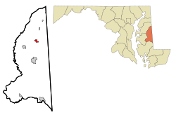
Caroline County Maryland Incorporated and Unincorporated areas Greensboro Highlighted.svg
Location of Greensboro, Maryland
USA Maryland location map.svg
Red pog.svg
Greensboro
Location within the U.S. state of Maryland
Usa edcp location map.svg
Red pog.svg
Greensboro
Greensboro (the United States)
Coordinates: 38°58′32″N75°48′25″W / 38.97556°N 75.80694°W / 38.97556; -75.80694
Country Flag of the United States.svg  United States of America
State Flag of Maryland.svg  Maryland
County Flag of Caroline County, Maryland.svg Caroline
Incorporated 1826 [1]
Area
[2]
  Total1.07 sq mi (2.78 km2)
  Land1.07 sq mi (2.78 km2)
  Water0.00 sq mi (0.00 km2)
Elevation
16 ft (5 m)
Population
 (2020)
  Total1,919
  Density1,786.78/sq mi (689.73/km2)
Time zone UTC-5 (Eastern (EST))
  Summer (DST) UTC-4 (EDT)
ZIP code
21639
Area code 410
FIPS code 24-35200
GNIS feature ID0590381
Website www.greensboromd.com

Greensboro is a town located on the banks of the Choptank River in Caroline County, Maryland, United States. The population was 1,931 at the 2010 United States Census. The ZIP code is 21639. The primary phone exchange is 482 and the area code is 410. The town is served by Maryland Routes 480 and 313.

Contents

Greensboro hosted the Caroline County Softball League, which produced both state and national champions.

Willow Grove was listed on the National Register of Historic Places in 1972. [3] Leonard House was listed in 1988 and Brick House Farm in 2009. [3]

Geography

Greensboro is located at 38°58′32″N75°48′25″W / 38.975441°N 75.806982°W / 38.975441; -75.806982 . [4]

According to the United States Census Bureau, the town has a total area of 1.05 square miles (2.72 km2), all land. [5]

Demographics

Historical population
CensusPop.Note
1860 406
1870 56138.2%
1880 68421.9%
1890 90231.9%
1900 641−28.9%
1910 609−5.0%
1920 6689.7%
1930 76013.8%
1940 737−3.0%
1950 1,18160.2%
1960 1,160−1.8%
1970 1,1731.1%
1980 1,2536.8%
1990 1,44115.0%
2000 1,63213.3%
2010 1,93118.3%
2020 1,919−0.6%
U.S. Decennial Census [6]

2010 census

As of the census [7] of 2010, there were 1,931 people, 703 households, and 477 families living in the town. The population density was 1,839.0 inhabitants per square mile (710.0/km2). There were 798 housing units at an average density of 760.0 per square mile (293.4/km2). The racial makeup of the town was 75.8% White, 13.6% African American, 0.9% Native American, 0.8% Asian, 1.4% Pacific Islander, 4.0% from other races, and 3.6% from two or more races. Hispanic or Latino of any race were 9.4% of the population.

There were 703 households, of which 42.4% had children under the age of 18 living with them, 42.0% were married couples living together, 18.3% had a female householder with no husband present, 7.5% had a male householder with no wife present, and 32.1% were non-families. 27.3% of all households were made up of individuals, and 12.4% had someone living alone who was 65 years of age or older. The average household size was 2.74 and the average family size was 3.30.

The median age in the town was 30.2 years. 30% of residents were under the age of 18; 10.5% were between the ages of 18 and 24; 30.2% were from 25 to 44; 19.5% were from 45 to 64; and 9.8% were 65 years of age or older. The gender makeup of the town was 46.5% male and 53.5% female.

2000 census

As of the census [8] of 2000, there were 1,632 people, 616 households, and 407 families living in the town. The population density was 2,451.3 inhabitants per square mile (946.5/km2). There were 674 housing units at an average density of 1,012.4 per square mile (390.9/km2). The racial makeup of the town was 78.86% White, 16.91% African American, 0.06% Native American, 0.67% Asian, 1.78% from other races, and 1.72% from two or more races. Hispanic or Latino of any race were 2.63% of the population.

There were 616 households, out of which 40.6% had children under the age of 18 living with them, 41.7% were married couples living together, 19.6% had a female householder with no husband present, and 33.9% were non-families. 29.1% of all households were made up of individuals, and 13.6% had someone living alone who was 65 years of age or older. The average household size was 2.64 and the average family size was 3.28.

In the town, the population was spread out, with 32.4% under the age of 18, 9.4% from 18 to 24, 29.4% from 25 to 44, 16.5% from 45 to 64, and 12.3% who were 65 years of age or older. The median age was 31 years. For every 100 females, there were 85.0 males. For every 100 females age 18 and over, there were 80.8 males.

The median income for a household in the town was $31,397, and the median income for a family was $36,083. Males had a median income of $27,092 versus $20,729 for females. The per capita income for the town was $13,787. About 15.6% of families and 16.5% of the population were below the poverty line, including 21.6% of those under age 18 and 17.1% of those age 65 or over.
Communities

Transportation

MD 313 northbound in Greensboro 2022-06-22 12 53 21 View north along Maryland State Route 313 (Greensboro Road) at Maryland State Route 314 (Whiteleysburg Road) in Greensboro, Caroline County, Maryland.jpg
MD 313 northbound in Greensboro

The primary means of travel to and from Greensboro is by road. The town lies at the junction of three state highways: Maryland Route 313, which travels north-south through the town, Maryland Route 314, which travels east from the town, and Maryland Route 480, which heads southwest from the town.

Notable people

Related Research Articles

<span class="mw-page-title-main">Caroline County, Maryland</span> County in Maryland, United States

Caroline County is a rural county located in the U.S. state of Maryland on its Eastern Shore. As of the 2020 census, the population was 33,293. Its county seat is Denton.

<span class="mw-page-title-main">Greensboro, Indiana</span> Town in Indiana, United States

Greensboro is a town in Greensboro Township, Henry County, Indiana, United States. The population was 143 at the 2010 census. The town was a 'station' on the Underground Railroad and was recognized for its active abolitionists.

<span class="mw-page-title-main">Clear Lake, Indiana</span> Town in Indiana, United States

Clear Lake is a town located in the northeast corner of Steuben County, Indiana, in Clear Lake Township. As such, is the northeasternmost community in the State of Indiana. The population was 339 at the 2010 census.

<span class="mw-page-title-main">Denton, Maryland</span> Town in Maryland

Denton is a town in Caroline County, Maryland, United States. The population of Denton was 4,418 as of the 2010 United States Census, and it is the county seat of Caroline County.

<span class="mw-page-title-main">Marydel, Maryland</span> Town in Maryland

Marydel is an incorporated town in Caroline County, Maryland, United States. The population was 141 at the 2010 United States Census. Its name is a portmanteau, after its location, being partially located in Maryland and partially in Delaware. Marydel was originally known as Halltown.

<span class="mw-page-title-main">Algonquin, Maryland</span> Census-designated place in Maryland, United States

Algonquin is a census-designated place (CDP) in Dorchester County, Maryland, United States. The population was 1,241 at the 2010 census. The community was named for the Algonquin people, one of the Native American tribes in the East.

<span class="mw-page-title-main">Oxford, Maryland</span> Town in Maryland, United States

Oxford is a waterfront town and former colonial port in Talbot County, Maryland, United States. The population was 651 at the 2010 census.

<span class="mw-page-title-main">Tilghman Island, Maryland</span> CDP in Maryland, United States

Tilghman Island is an island in the Chesapeake Bay. It is part of Talbot County, Maryland, United States.

<span class="mw-page-title-main">Berlin, Maryland</span> Town in Maryland, United States

Berlin is a town in Worcester County, Maryland, United States which includes its own historical Berlin Commercial District. The population was 4,485 at the 2010 census, and has since grown in population. It is part of the Salisbury, Maryland-Delaware Metropolitan Statistical Area.

<span class="mw-page-title-main">Oak Ridge, North Carolina</span> Town in North Carolina, United States

Oak Ridge is a town in northwestern Guilford County, North Carolina, United States. The population was 6,185 at the 2010 census, up from 3,988 in 2000. As of 2018, the population had risen to an estimated 6,977. Oak Ridge is 15 miles (24 km) northwest of the center of Greensboro, North Carolina's third-largest city, and it is a part of the Piedmont Triad urban area.

<span class="mw-page-title-main">Stokesdale, North Carolina</span> Town in North Carolina, United States

Stokesdale is a town in Guilford County with a small part in Rockingham County, North Carolina, United States. The population was 5,924 at the 2020 census. Belews Lake is located nearby, and North Carolina Highway 68 and North Carolina Highway 65 both intersect U.S. Route 158 near the town's center.

<span class="mw-page-title-main">Kittanning Township, Armstrong County, Pennsylvania</span> Township in Pennsylvania, United States

Kittanning Township is a township in Armstrong County, Pennsylvania, United States. The population was 2,019 at the 2020 census, a decrease from the figure of 2,265 tabulated in 2010.

<span class="mw-page-title-main">Redbank Township, Armstrong County, Pennsylvania</span> Township in Pennsylvania, United States

Redbank Township is a township in Armstrong County, Pennsylvania, United States. The population was 975 at the 2020 census, a decrease from the figure of 1,064 tabulated in 2010.

<span class="mw-page-title-main">South Buffalo Township, Armstrong County, Pennsylvania</span> Township in Pennsylvania, United States

South Buffalo Township is a township in Armstrong County, Pennsylvania, United States. The population was 2,713 at the 2020 census, an increase from the figure of 2,636 tabulated in 2010.

<span class="mw-page-title-main">Sugarcreek Township, Armstrong County, Pennsylvania</span> Township in Pennsylvania, United States

Sugarcreek Township is a township in Armstrong County, Pennsylvania, United States. The population was 1,336 at the 2020 census, a decrease from the figure of 1,539 tabulated in 2010.

<span class="mw-page-title-main">Sheffield, Vermont</span> Town in Vermont, United States

Sheffield is a town in Caledonia County, Vermont, United States. The population was 682 at the 2020 census.

<span class="mw-page-title-main">Mendon, Vermont</span> Town in Vermont, United States

Mendon is a town in Rutland County, Vermont, United States. The population was 1,149 at the 2020 census.

<span class="mw-page-title-main">Fairfield, Wisconsin</span> Town in Wisconsin, United States

The Town of Fairfield is located in Sauk County, Wisconsin, United States. The population was 1,078 at the 2020 census. The unincorporated community of Greens Corners is located in the town.

<span class="mw-page-title-main">Queen Anne, Maryland</span> Town in Maryland, United States of America

Queen Anne is a town in Queen Anne's and Talbot counties in the U.S. state of Maryland. The population was 222 at the 2010 census.

<span class="mw-page-title-main">Sherman, New York</span> Town in New York, United States

Sherman is a town in Chautauqua County, New York, United States. It is an interior town in the county, west of Chautauqua Lake. As of the 2020 census, the town population was 1,618. The town contains the village of Sherman.

References

  1. "Greensboro". Maryland Manual. Retrieved June 25, 2017.
  2. "2020 U.S. Gazetteer Files". United States Census Bureau. Retrieved April 26, 2022.
  3. 1 2 "National Register Information System". National Register of Historic Places . National Park Service. March 13, 2009.
  4. "US Gazetteer files: 2010, 2000, and 1990". United States Census Bureau. February 12, 2011. Retrieved April 23, 2011.
  5. "US Gazetteer files 2010". United States Census Bureau. Archived from the original on January 25, 2012. Retrieved January 25, 2013.
  6. "Census of Population and Housing". Census.gov. Retrieved June 4, 2015.
  7. "U.S. Census website". United States Census Bureau . Retrieved January 25, 2013.
  8. "U.S. Census website". United States Census Bureau . Retrieved January 31, 2008.
  9. "Maple Village". Geographic Names Information System . United States Geological Survey, United States Department of the Interior.
  10. "Foxgrape Farm". Geographic Names Information System . United States Geological Survey, United States Department of the Interior.
  11. "Choptank Overlook". Geographic Names Information System . United States Geological Survey, United States Department of the Interior.
  12. "Four Corners". Geographic Names Information System . United States Geological Survey, United States Department of the Interior.
  13. "Three Corners". Geographic Names Information System . United States Geological Survey, United States Department of the Interior.