Related Research Articles

Virgil is a village in Virgil Township, Kane County, Illinois, United States. It was incorporated on November 6, 1990. The population was 329 at the 2010 census, up from 266 in 2000.
Uskmouth is an area to the south of the city of Newport, South Wales.

Senneterre is a town in the Abitibi-Témiscamingue region of northwestern Quebec, Canada. It is in the Vallée-de-l'Or Regional County Municipality. The town's territory includes a vast undeveloped area stretching from the Bell River to the Mauricie region. The town centre itself is about 60 km (37 mi) northeast of Val-d'Or on the banks of the Bell River, at the intersection of the Canadian National Railway and Quebec Route 113.
The LORAN-C transmitter Jan Mayen was a LORAN-C transmission facility on the island of Jan Mayen at 70°54′51″N8°43′57″W. The LORAN-C transmitter Jan Mayen used as an antenna had a 190-metre tall (625 ft) guyed mast.
There are several lakes named Mud Lake in the U.S. state of Colorado.
South Hagerstown High School is located at 1101 South Potomac Street, in Hagerstown, Maryland, United States. The current principal is Rodney Gayman. The 164,000 square-foot school is part of the Washington County Public Schools system and has an official capacity of 1209.
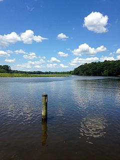
Tuckahoe Creek is a 21.5-mile-long (34.6 km) tributary of the Choptank River on Maryland's Eastern Shore. It is sometimes (erroneously) referred to as the Tuckahoe River. Upstream of Hillsboro, it forms the boundary between Caroline County and Queen Anne's County, passing through Tuckahoe State Park and dividing the small towns of Queen Anne and Hillsboro. Downstream of Hillsboro, it forms the boundary between Caroline County and Talbot County, before flowing into the Choptank.
Third Lake could refer to one of many lakes:
Matthews is an unincorporated community in Talbot County, Maryland, United States. Rock Clift was listed on the National Register of Historic Places in 1980.
Zalesie is a village in the administrative district of Gmina Lidzbark, within Działdowo County, Warmian-Masurian Voivodeship, in northern Poland. It lies approximately 8 kilometres (5 mi) north-west of Lidzbark, 31 km (19 mi) west of Działdowo, and 75 km (47 mi) south-west of the regional capital Olsztyn.
Grove is a populated place in Caroline County, Maryland, United States.
Jumptown is an unincorporated community in Caroline County, Maryland, United States.

Linnaka is a village in Saaremaa Parish, Saare County in western Estonia.
Meredithville is an unincorporated community located in Brunswick County, in the U.S. state of Virginia.
South Gate is an unincorporated community in Whitewater Township, Franklin County, Indiana, USA.
Sherman is an unincorporated community in Grant County, Kentucky, in the United States.
Schumaker Pond is a 35-acre pond created by damming Beaverdam Creek, in Wicomico County, Maryland. The pond is owned by the City of Salisbury and is on the eastern end of the Salisbury City Park. The maximum water depth is 5 feet near the dam, in the old creek channel. In the 1950s-60s Schumaker Pond was popular for swimming, but swimming has since been banned due to the large quantities of E-Coli bacteria in the water. Today, the pond is often used for fishing.
Wagram is an unincorporated community in Licking County, in the U.S. state of Ohio.

Maysville is an unincorporated community in Allen and Hardin counties, in the U.S. state of Ohio.
Whiteleysburg is an unincorporated community in Kent County, Delaware, United States. Whiteleysburg is located at the intersection of Delaware Route 12 and Whiteleysburg Road, just east of the Maryland border.
References
Municipalities and communities of Caroline County, Maryland, United States | ||
|---|---|---|
| Towns |  | |
| CDPs | ||
| Unincorporated communities | ||
| Footnotes | ‡This populated place also has portions in an adjacent county or counties | |
Coordinates: 38°57′24″N75°43′57″W / 38.95667°N 75.73250°W