
Caroline County is a rural county located in the U.S. state of Maryland on its Eastern Shore. As of the 2020 census, the population was 33,293. Its county seat is Denton.

Shady Side is a census-designated place (CDP) in Anne Arundel County, Maryland, United States. The population was 5,803 at the 2010 census.

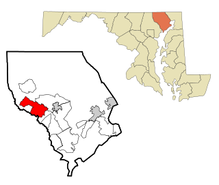
Denton is a town in Caroline County, Maryland, United States. The population of Denton was 4,418 as of the 2010 United States Census, and it is the county seat of Caroline County.
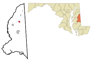
Greensboro is a town located on the banks of the Choptank River in Caroline County, Maryland, United States. The population was 1,931 at the 2010 United States Census. The ZIP code is 21639. The primary phone exchange is 482 and the area code is 410. The town is served by Maryland Routes 480 and 313.
Fallston is a census-designated place (CDP) in Harford County, Maryland, United States. The population was 8,958 at the 2010 census, up from 8,427 in 2000. Fallston is a semi-rural community consisting mostly of farms and suburban-like developments.

Point of Rocks is an unincorporated community and census-designated place (CDP) in Frederick County, Maryland, United States. As of the 2010 census it had a population of 1,466. It is named for the striking rock formation on the adjacent Catoctin Mountain, which was formed by the Potomac River cutting through the ridge in a water gap, a typical formation in the Appalachian Mountains. The formation is not visible from the town and can only be seen from boats on the river, or from the southern bank of the river in Virginia.

Jefferson is an unincorporated community and census-designated place (CDP) in Frederick County, Maryland, United States. As of the 2020 census the town had a population of 2,235. Jefferson was established in 1774 and incorporated as a town in 1831. However, a year later, in 1832, the citizens of the town decided that municipal government was unnecessary, and dis-incorporated the town, which has been unincorporated since then.

Savage is an unincorporated community and census-designated place located in Howard County, Maryland, United States, approximately 18 miles (29 km) south of Baltimore and 21 miles (34 km) north of Washington, D.C. It is situated close to the city of Laurel and to the planned community of Columbia. As of the 2020 census, it had a population of 7,542. The former mill town is a registered historic place, and has several original buildings preserved within and around the Savage Mill Historic District.
Choptank is an unincorporated town and census-designated place on the Eastern Shore of Maryland, in Caroline County, Maryland, United States. As of the 2010 census it had a population of 129.
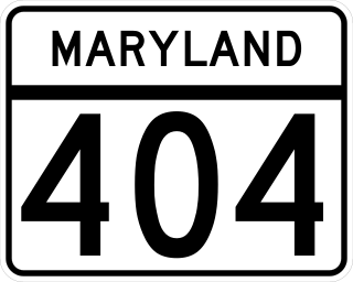
Maryland Route 404 (MD 404) is a major highway on Maryland's Eastern Shore in the United States. Signed east-west, it runs 24.61 miles (39.61 km) from MD 662 in Wye Mills on the border of Queen Anne's and Talbot counties, southeast to the Delaware state line in Caroline County, where the road continues as Delaware Route 404 (DE 404) to the Five Points intersection near Rehoboth Beach. The Maryland and Delaware state highways together cross the width of the Delmarva Peninsula and serve to connect the Baltimore–Washington Metropolitan Area by way of the Chesapeake Bay Bridge and U.S. Route 50 (US 50) with the Delaware Beaches. Along the way, MD 404 passes through mostly farmland and woodland as well as the towns of Queen Anne, Hillsboro, and Denton. The route is a four-lane divided highway between US 50 and east of Denton, with the remainder of the route a two-lane undivided road.
Bloomington is an unincorporated community and census-designated place (CDP) locates in southeastern Garrett County, Maryland located at the confluence of the North Branch Potomac River and Savage River. It lies to the west of Luke on Maryland Route 135 and is bounded to the northwest by Savage River State Forest. As of the 2010 census the population of Bloomington was 305.
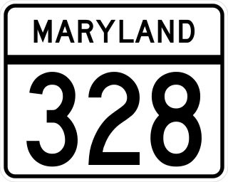
Maryland Route 328 is a state highway in the U.S. state of Maryland. The state highway runs 15.24 mi (24.53 km) from U.S. Route 50 in Easton east to just north of MD 404 in West Denton. MD 328 connects Easton with Denton, passing through eastern Talbot County and a neck of land in Caroline County between the Choptank River and Tuckahoe Creek. MD 328 was constructed in Talbot County in the late 1910s between downtown Easton and a point west of Matthews. The state highway was constructed in Caroline County in the late 1920s and early 1930s, and was originally designated MD 457. The gap between the two highways was filled in the late 1940s and included a modern bridge over Tuckahoe Creek. MD 328's western terminus was moved to US 50 in the early 1960s. In West Denton, the highway was relocated and extended north to present MD 404 in the early 1980s.
Williston is an unincorporated town and census-designated place on the Eastern Shore of the U.S. state of Maryland, in Caroline County. As of the 2010 census it had a population of 155. It is situated between Maryland Route 16 on its eastern edge and the Choptank River on its west. It was originally known as Potter's Landing for its first resident, Zabdiel Potter. His home, Potter Hall, was listed on the National Register of Historic Places in 1982.

Buckeystown is an unincorporated community and census-designated place (CDP) in Frederick County, Maryland, United States. As of the 2010 census the population was 1,019. Buckeystown Historic District and Buckingham House and Industrial School Complex were listed on the National Register of Historic Places in 1982. Carrollton Manor was listed in 1997. Former Congressman Roscoe Bartlett lives on a farm in the town.
Scaggsville is an unincorporated community and census-designated place in Howard County, Maryland, United States. It is situated near the southeastern tip of Howard County, between Laurel and Fulton. As of the 2010 census it had a population of 24,333. The town mainly consists of residences, with some commercial establishments. Scaggsville generally falls within ZIP code 20723, assigned to Laurel, though the town formerly had its own post office.

Taylors Island is an unincorporated community and census-designated place in Dorchester County, Maryland, United States, in the state's Eastern Shore region. The population was 173 at the 2010 census. It is known for hunting, crabbing and fishing. Ridgeton Farm was listed on the National Register of Historic Places in 1977. Bethlehem Methodist Episcopal Church and Grace Episcopal Church Complex were listed in 1979.

Fairplay is an unincorporated community and census-designated place (CDP) in Washington County, Maryland, United States. Its population was 580 as of the 2010 census. It is sometimes recognized, along with neighboring Tilghmanton, as Fairplay-Tilghmanton; the two communities share a post office as well as a fire company. Fairplay is located between Hagerstown and Sharpsburg, along Maryland Route 65 and is part of the Hagerstown Metropolitan Area. Marsh Mills was listed on the National Register of Historic Places in 1996.

Libertytown is an unincorporated community and census-designated place (CDP) in Frederick County, in the U.S. state of Maryland. As of the 2010 census it had a population of 950. The unofficial mayor is Sean Dixon. The Abraham Jones House was listed on the National Register of Historic Places in 1973.

Madison is an unincorporated community and census-designated place (CDP) in Dorchester County, Maryland, United States. The population was 204 at the 2010 census.

Finesville is an unincorporated community and census-designated place (CDP) located within Pohatcong Township in Warren County, in the U.S. state of New Jersey. The CDP was defined as part of the 2010 United States Census. As of the 2010 Census, the CDP's population was 175.

