Denton is a town in Caroline County, Maryland, United States. The population of Denton was 4,418 as of the 2010 United States Census, and it is the county seat of Caroline County.
Greensboro is a town located on the banks of the Choptank River in Caroline County, Maryland, United States. The population was 1,931 at the 2010 United States Census. The ZIP code is 21639. The primary phone exchange is 482 and the area code is 410. The town is served by Maryland Routes 480 and 313.
The Choptank River is a major tributary of the Chesapeake Bay and the largest river on the Delmarva Peninsula. Running for 71 miles (114 km), it rises in Kent County, Delaware, runs through Caroline County, Maryland, and forms much of the border between Talbot County, Maryland, on the north, and Caroline County and Dorchester County on the east and south. It is located north of the Nanticoke River, and its mouth is located south of Eastern Bay. Cambridge, the county seat of Dorchester County, and Denton, the county seat of Caroline County, are located on its south shore.
American Corner is a populated place in Caroline County, Maryland, United States. American Corner is home to Colonel Richardson High School and Colonel Richardson Middle School. On older maps, it is sometimes referred to as American Corners. There was formerly a post office, cannery, blacksmith, and a store located there, as seen on the 1875 and 1897 Maps of Caroline County, Maryland.

Antietam Creek is a 41.7-mile-long (67.1 km) tributary of the Potomac River located in south central Pennsylvania and western Maryland in the United States, a region known as the Hagerstown Valley. The creek became famous as a focal point of the Battle of Antietam during the American Civil War.
Carp River is a 40.2-mile-long (64.7 km) river in Chippewa and Mackinac counties in the U.S. state of Michigan. 21.7 miles (34.9 km) of the river were added to the National Wild and Scenic Rivers System in 1992.
The Black River is a 41.1-mile-long (66.1 km) river on the Upper Peninsula of the U.S. state of Michigan, flowing mostly in Gogebic County into Lake Superior at 46°40′03″N90°02′57″W. Its source at 46°18′54″N90°01′15″W is a boreal wetland on the border with Iron County, Wisconsin. The northern section of the river, 14 miles (23 km) within the boundaries of the Ottawa National Forest, was designated a National Wild and Scenic River in 1992.
Andersontown is a populated place on Maryland's Eastern Shore in Caroline County, Maryland, United States. It is situated near the Delaware line, centered on the intersection of Andersontown Road and Maryland Route 404.
Gilpin Point is a cape on Maryland's Eastern Shore in Caroline County, Maryland, United States. It was the home of Revolutionary War soldier William Richardson, who distinguished himself in the Battle of Harlem Heights. There is a tomb dedicated to him next to Gilpin's Point Landing Park. It was placed by the Caroline County Historical Society in the 1950s.
Two Johns, is an unincorporated community on Maryland's Eastern Shore in Caroline County, Maryland, United States. It is situated on Maryland Route 16. The name derives from an early resident who was a vaudeville actor, John Stewart Crossy. He toured with John Hart and a series of other girthy men as the "Two Johns" or the "Fat Men's Club" during the height of his popularity. The village appears on the 1897 Map of Caroline County.

The Cedar River is a 29.0-mile-long (46.7 km) river in the U.S. state of Michigan, flowing through Clare County and Gladwin County.

Conewago Creek is an 80.2-mile-long (129.1 km) tributary of the Susquehanna River in Adams and York counties in Pennsylvania in the United States, with its watershed also draining a small portion of Carroll County, Maryland. The source is at an elevation of 1,440 feet (440 m), east of Caledonia State Park, in Franklin Township in Adams County. The mouth is the confluence with the Susquehanna River at York Haven in York County at an elevation of 259 feet (79 m).

Tuckahoe Creek is a 21.5-mile-long (34.6 km) tributary of the Choptank River on Maryland's Eastern Shore. It is sometimes (erroneously) referred to as the Tuckahoe River. Upstream of Hillsboro, it forms the boundary between Caroline County and Queen Anne's County, passing through Tuckahoe State Park and dividing the small towns of Queen Anne and Hillsboro. Downstream of Hillsboro, it forms the boundary between Caroline County and Talbot County, before flowing into the Choptank.
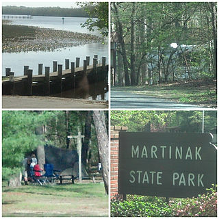
Martinak State Park is a public recreation area located on the Choptank River and Watts Creek, immediately south of Denton in Caroline County, Maryland. The park bears the name of George Martinak, who deeded his land to the state in 1961. The park opened in 1964. Site improvements including the addition of campsites, roads, and park office took place from 1964 to 1974. The park features boating access, fishing, campsites and cabins, hiking trails, a nature center, and painted rocks.
Bethlehem is a populated place in Caroline County, Maryland, United States. Bethlehem is located at the intersection of Maryland routes 331 and 578, northwest of Preston.
Burrsville is a populated place in Caroline County, Maryland, United States. One of the first references is on the 1875 Map of Caroline County, where the Burrsville Post Office appears. Burrsville is located near the Delaware border.
Reliance is an unincorporated community located on the border of the U.S. states of Maryland and Delaware. The Maryland side of the community has portions in Caroline and Dorchester counties, while the Delaware side is located within Sussex County. Reliance is along Delaware Route 20 and Maryland Route 392 at the junction with Maryland Route 577, west of Seaford. It was previously known as Johnson's Crossroads.
Hickman is an unincorporated community in Kent County, Delaware, United States. Hickman is located along Delaware Route 16 at the border with Caroline County, Maryland and just north of the Sussex County border, northwest of Greenwood.

Sumneytown is an unincorporated community that is situated on Route 63 in Marlborough Township, Montgomery County, Pennsylvania, United States.
Hynson, is an unincorporated community on Maryland's Eastern Shore in Caroline County, Maryland, United States. The earliest record of its existence is from the 1875 Map of Caroline County, where it is referred to as Newhope. In the 1897 Map of Caroline County, it is referred to as Hynson. The Hynson Post Office was located there, which operated from 1881 to 1907.