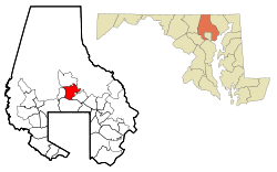
Lutherville, Maryland

Last updated

Lutherville, Maryland
LRT Lutherville 1 21Oct09.jpg
Lutherville light rail station platform on Ridgely Road, in Lutherville, Maryland
Nickname: 
Old Original
Baltimore County Maryland Incorporated and Unincorporated areas Lutherville-Timonium Highlighted.svg
Location of Lutherville, Maryland
Coordinates: 39°25′26″N76°37′3″W / 39.42389°N 76.61750°W / 39.42389; -76.61750
CountryFlag of the United States.svg United States
State Flag of Maryland.svg  Maryland
County Flag of Baltimore County, Maryland.svg Baltimore
Area
[1]
  Total2.11 sq mi (5.47 km2)
  Land2.11 sq mi (5.47 km2)
  Water0.00 sq mi (0.00 km2)
Population
 (2020)
  Total6,835
  Density3,233.21/sq mi (1,248.54/km2)
Time zone UTC−5 (Eastern (EST))
  Summer (DST) UTC−4 (EDT)
ZIP codes
21093-21094
Area code(s) 410, 443
FIPS code 24-48875

Lutherville is a census-designated place (CDP) in Baltimore County, Maryland, United States. As of the 2010 census it had a population of 6,504. [2] Prior to 2010 the area was part of the Lutherville-Timonium CDP. Within its borders lies the Lutherville Historic District.

Contents

Geography

Lutherville is located at 39°25′26″N76°37′3″W / 39.42389°N 76.61750°W / 39.42389; -76.61750 (39.4240, 76.6177). [3]

According to the United States Census Bureau, the CDP had a total area of 2.1 square miles (5.5 km2), all land. [4]

The town is located north of Baltimore City along York Road (Maryland Route 45). It is bordered on the north by Timonium, on the west by Interstate 83, on the south by Towson, and on the east by the Hampton neighborhood. The boundary between Lutherville and Timonium is Ridgely Road.

Lutherville is located in the Piedmont region of the United States, and lies in the humid subtropical climate zone, with hot and humid summers leading into winters that are chilly but not extreme by American standards. The average annual snowfall is 25 inches (64 cm) and average annual precipitation is 42 inches (107 cm).

Demographics

Historical population
CensusPop.Note
1960 12,265
1970 24,05596.1%
1980 17,854−25.8%
1990 16,442−7.9%
2000 15,814−3.8%
2010 6,504−58.9%
2020 6,8355.1%
Separated from Lutherville-Timonium CDP in 2010 Census [5]

As of the 2010 census, there were 6,504 people and 2,672 households in the CDP. [6] The racial makeup of the CDP is 85.0% White, 3.4% African American, 0.2% Native American, 8.2% Asian, 0.2% Native Hawaiian and Pacific Islander, and 3.3% Hispanic or Latino.

Out of the 2,672 households recorded in the 2010 census, 28.3% had children under the age of 18 living with them.

Transportation

Roads

Major roads in Lutherville include:

Public transportation

Northern Central Railway train at Lutherville during World War I (1917-1918) Train in Lutherville MD.jpg
Northern Central Railway train at Lutherville during World War I (19171918)

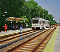
The Maryland Transit Administration's light rail line serves the community with the Lutherville Light Rail Stop. In addition, bus routes 8 and 9 provide regular service along the York Road corridor, meeting at the Lutherville Light Rail Stop. There is also a limited amount of bus service on Bus Route 12 along Dulaney Valley Road to Stella Maris Hospice. In addition, the Baltimore CityLink Red line serves the Lutherville Light Rail station.

The MTA light rail line uses the right-of-way of the old Northern Central Railway (later, part of the extensive Pennsylvania Railroad system). During the Civil War, President Abraham Lincoln travelled through Lutherville on this railroad en route to Gettysburg, Pennsylvania, to deliver the Gettysburg Address on November 19, 1863. Less than two years later, on April 21, 1865, Lincoln's funeral train also passed through Lutherville on its way from Washington, D.C. to his final resting place at Springfield, Illinois. [7] [8] The Pennsylvania Railroad (PRR) operated long-distance passenger trains from Baltimore over the line to Chicago, St. Louis, and Buffalo as late as the 1960s. The former PRR Lutherville freight and passenger station on Railroad Avenue is now a private residence.

History

Lutherville historic marker Lutherville Md marker.jpg
Lutherville historic marker
Oak Grove, the home of Lutherville founder John Morris, in 1872 Oak Grove in 1872.jpg
Oak Grove, the home of Lutherville founder John Morris, in 1872
Octagon House, built in 1855 Octagon House, Lutherville.jpg
Octagon House, built in 1855

The oldest section of Lutherville dates back to 1852, when it was founded by two Lutheran ministers as a planned community, anchored by a Lutheran seminary and church. The land was originally part of the vast Hampton Estate of Charles Ridgely, from whom it was purchased in 1851. [9]

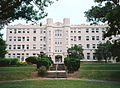
The two ministers, Benjamin Kurtz and John Morris, named the community after the 16th-century German reformer Martin Luther. [9] The Lutherville Female Seminary, as it was initially called when chartered in 1853, was built near the tracks of the Baltimore & Susquehanna Railroad, a forerunner of the Northern Central Railway. In 1895, the institution was renamed the Maryland College for Women. Following a devastating fire in 1911, the college was rebuilt and continued in operation until 1952. Its campus is now an adult congregate living facility, College Manor.
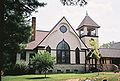
The Lutherville Historic District was added to the National Register of Historic Places in 1972. [9] [10] Notable structures, in addition to the old college building and the many Victorian homes, include:

Notable people

Education

Public schools

A portion of Lutherville's high school-age students attend nearby Towson High School.

Related Research Articles

<span class="mw-page-title-main">Baltimore County, Maryland</span> County in Maryland, United States

Baltimore County is the third-most populous county in the U.S. state of Maryland. It is part of the Baltimore metropolitan area.

<span class="mw-page-title-main">Glen Burnie, Maryland</span> Census-designated place in Maryland, United States

Glen Burnie is an unincorporated town and census-designated place (CDP) in Anne Arundel County, Maryland, United States. It is a suburb of Baltimore. The population was 72,891 at the 2020 census.

<span class="mw-page-title-main">Linthicum, Maryland</span> Census-designated place in Maryland, United States

Linthicum is a census-designated place (CDP) and unincorporated community in Anne Arundel County, Maryland, United States. The population was 10,324 at the 2010 census. It is located directly north of Baltimore–Washington International Thurgood Marshall Airport (BWI).

<span class="mw-page-title-main">Odenton, Maryland</span> Census-designated place in Maryland, U.S.

Odenton is a census-designated place (CDP) in Anne Arundel County, Maryland, United States, located approximately 10–20 minutes from the state capital, Annapolis. The population was 37,132 at the 2010 census, up from 20,534 at the 2000 census. The town's population growth rate of 80.8% between 2000 and 2010 was the greatest of any town in western Anne Arundel County. Odenton is located west of Annapolis, south of Baltimore, and northeast of Washington.

<span class="mw-page-title-main">Severna Park, Maryland</span> Census-designated place in Maryland, United States

Severna Park is a census-designated place (CDP) in Anne Arundel County, Maryland, United States. Severna Park is part of the Baltimore-Washington Metropolitan Area, and is located approximately 8 miles (13 km) north of Annapolis, 17 miles (27 km) south of Baltimore and 39 miles (63 km) east of Washington, D.C. Severna Park's population was 39,933 at the 2020 census.

<span class="mw-page-title-main">Catonsville, Maryland</span> Census-designated place in Maryland, United States

Catonsville is a census-designated place (CDP) in Baltimore County, Maryland. The population was 44,701 at the 2020 US Census. The community is a streetcar suburb of Baltimore along the city's western border. The town is known for its proximity to the Patapsco River and Patapsco Valley State Park, making it a regional mountain biking hub. The town is also notable as a local hotbed of music, earning it the official nickname of "Music City, Maryland." Catonsville contains the majority of the University of Maryland, Baltimore County (UMBC), a major public research university with close to 14,000 students.

<span class="mw-page-title-main">Cockeysville, Maryland</span> Census-designated place in Maryland, United States

Cockeysville is a census-designated place (CDP) in Baltimore County, Maryland, United States. The population was 20,776 at the 2010 census.

<span class="mw-page-title-main">Lutherville-Timonium, Maryland</span> Former census-designated place in Maryland, United States

Lutherville-Timonium was a census-designated place (CDP) in Baltimore County, Maryland, United States, for the 2000 census. At that time the population was 15,814. For the 2010 census the area was split into two CDPs, the unincorporated communities of Lutherville and Timonium. Within its borders lies the Lutherville Historic District. The Maryland State Fair is held in Timonium each year near Labor Day.

<span class="mw-page-title-main">Towson, Maryland</span> Census-designated place in Maryland, United States

Towson is an unincorporated community and a census-designated place in Baltimore County, Maryland, United States. The population was 55,197 as of the 2010 census. It is the county seat of Baltimore County and the second-most populous unincorporated county seat in the United States.

<span class="mw-page-title-main">Timonium, Maryland</span> Census-designated place in Maryland, United States

Timonium is a census-designated place (CDP) in Baltimore County, Maryland, United States. As of the 2010 census it had a population of 9,926. Prior to 2010 the area was part of the Lutherville-Timonium CDP.

<span class="mw-page-title-main">Dulaney Valley Memorial Gardens</span> Cemetery and mausoleum in Timonium, Maryland, US

Dulaney Valley Memorial Gardens and Mausoleum is a cemetery and mausoleum in Timonium, Maryland, a Baltimore County suburban community. It is located at 200 E. Padonia Rd, about two miles (3 km) east from the Padonia Road exit off Interstate 83. The 7th and 6th holes of the Longview Golf Course border much of the cemetery; the other borders are Padonia Road and a residential neighborhood. The cemetery's administrative offices are directly across the street from the main entrance to the burial park. Another entrance leading to Gibbons Road is normally kept locked.

<span class="mw-page-title-main">Lansdowne, Maryland</span> Census-designated place in Maryland, United States

Lansdowne is a census-designated place in southern Baltimore County, Maryland, United States, located just south of Baltimore. As of the 2010 census, it had a population of 8,409. At the 2000 census and earlier, the area was delineated as part of the Lansdowne-Baltimore Highlands CDP.

<span class="mw-page-title-main">Maryland State Fair</span> Annual state for Maryland, United States

"The Maryland State Fair is an annual event held in the state of Maryland. It is hosted at the Maryland State Fairgrounds, located near York and Timonium roads in Timonium. As of 2006, the fair has been traditionally scheduled for a duration of 11 days. It typically begins in late August and concludes around Labor Day."

<span class="mw-page-title-main">Maryland Route 146</span> State highway in Maryland, US

Maryland Route 146 is a state highway in the U.S. state of Maryland. The state highway runs 16.81 miles (27.05 km) from MD 45 in Towson north to MD 23 near Jarrettsville. MD 146 connects Towson with Loch Raven Reservoir, an impoundment of Gunpowder Falls. The state highway also serves the northern Baltimore County community of Jacksonville and Jarrettsville in western Harford County. MD 146 was constructed as two different state highways on either side of Loch Raven Reservoir. The section of the state highway in Towson was built in the 1910s and the portion through Jacksonville to Jarrettsville was constructed in the late 1920s and early 1930s. The gap in MD 146 through Loch Raven Reservoir was filled in two steps of maintenance swaps in the early 1960s and late 1970s.

<span class="mw-page-title-main">Maryland Route 131</span> State highway in Baltimore County, Maryland, known as Seminary Ave

Maryland Route 131 is a state highway located in Baltimore County in the U.S. state of Maryland. Known as Seminary Avenue, the state highway runs 3.06 miles (4.92 km) from MD 25 in Brooklandville east to MD 45 in Lutherville. MD 131 was mostly constructed by 1910, with the remainder completed in the early 1920s.

John G. Trueschler, was a member of the Maryland House of Delegates, District 42.

<span class="mw-page-title-main">Sean Rush</span> American soccer player (born 1985)

Sean Patrick Rush is an American soccer player who last played for Ribeirão in the Portuguese Second Division.

<span class="mw-page-title-main">Ridgely Middle School</span> School in Lutherville-Timonium, Maryland, United States

Ridgely Middle School is a Blue Ribbon-award-winning middle school that serves students in sixth through eighth grades as part of the Baltimore County Public Schools. This school serves students coming from elementary schools in Lutherville, Timonium, Hampton and Ruxton-Riderwood, Maryland.

<span class="mw-page-title-main">Brooklandville, Maryland</span> Unincorporated community in Maryland, United States

Brooklandville is an unincorporated community in Baltimore County, Maryland, United States near the intersection of Jones Falls Expressway and the Baltimore Beltway. The general area is a part of Lutherville, and some addresses in the area are considered to be in Lutherville, though Brooklandville has a postal zone and post office of its own. Some notable landmarks in the area, including the Park School of Baltimore and St. Paul's Schools are technically within Brooklandville, as noted by their mailing addresses. However, addresses within the main office complex in the area, Green Spring Station, are considered to be within Lutherville.

Route 52 is a bus route operated by the Maryland Transit Administration in Baltimore and its suburbs. The line is a dedicated service for employees of Stella Maris, a complex of long term care facilities in Timonium, Maryland. Route 52 replaced Route 12 under BaltimoreLink.

References

  1. "2020 U.S. Gazetteer Files". United States Census Bureau. Retrieved April 26, 2022.
  2. "Profile of General Population and Housing Characteristics: 2010 Demographic Profile Data (DP-1): Lutherville CDP, Maryland". United States Census Bureau . Retrieved February 23, 2012.
  3. "US Gazetteer files: 2010, 2000, and 1990". United States Census Bureau. February 12, 2011. Retrieved April 23, 2011.
  4. "Geographic Identifiers: 2010 Demographic Profile Data (G001): Lutherville CDP, Maryland". United States Census Bureau . Retrieved February 23, 2012.
  5. "Census of Population and Housing". Census.gov. Retrieved June 4, 2016.
  6. "U.S. Census website" . Retrieved March 29, 2019.
  7. Daniel Carroll Toomey (1997). Baltimore During the Civil War. Toomey Press. p. 170. ISBN   0-9612670-7-0.
  8. "The Route of Abraham Lincoln's Funeral Train". December 29, 1996. Retrieved April 15, 2008.
  9. 1 2 3 "Lutherville, Maryland   a Victorian Experience". Baltimore County Public Library. January 25, 2008. Archived from the original on November 1, 2009. Retrieved July 19, 2009.
  10. "National Register Information System". National Register of Historic Places . National Park Service. April 15, 2008.
  11. "The Divine Childhood Home of John Waters". Wall Street Journal . April 11, 2017. Retrieved July 18, 2020.(subscription required)
  12. Gunts, Ed (July 17, 2020). "Filmmaker John Waters' boyhood home goes up for sale". baltimorefishbowl.com. Retrieved July 18, 2020.
  13. http://www.washingtonbayhawks.com/team/roster/index.html?player_id=49 Archived 2008-07-05 at the Wayback Machine Washington Bayhawk Player Bio
  14. "Still Waters". New York Magazine. Retrieved November 19, 2015.
  15. "A very sober-minded Derek Waters on work, life and doing Baltimore in Season 2 of 'Drunk History'". Baltimore Sun. Retrieved February 18, 2016.