Baldwin, Maryland

Last updated
Baldwin, Maryland
Unincorporated community
USA Maryland location map.svg
Red pog.svg
Baldwin, Maryland
Location within the State of Maryland
Usa edcp location map.svg
Red pog.svg
Baldwin, Maryland
Baldwin, Maryland (the US)
Coordinates: 39°29′41″N76°28′13″W / 39.49472°N 76.47028°W / 39.49472; -76.47028 Coordinates: 39°29′41″N76°28′13″W / 39.49472°N 76.47028°W / 39.49472; -76.47028
Country Flag of the United States.svg United States
State Flag of Maryland.svg  Maryland
County Flag of Baltimore County, Maryland.svg Baltimore
Time zone Eastern (EST) (UTC-5)
  Summer (DST) EDT (UTC-4)
GNIS feature ID 589687

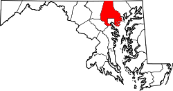
Baldwin is an unincorporated community in Baltimore County, Maryland, United States. [1] The United States Postal Service has assigned Baldwin the ZIP Code 21013. [2] Until 1958, this community was served by the Maryland and Pennsylvania Railroad at milepost 18.4. Hidden Valley Farm was listed on the National Register of Historic Places in 1983. [3]

Unincorporated area Region of land not governed by own local government

In law, an unincorporated area is a region of land that is not governed by a local municipal corporation; similarly an unincorporated community is a settlement that is not governed by its own local municipal corporation, but rather is administered as part of larger administrative divisions, such as a township, parish, borough, county, city, canton, state, province or country. Occasionally, municipalities dissolve or disincorporate, which may happen if they become fiscally insolvent, and services become the responsibility of a higher administration. Widespread unincorporated communities and areas are a distinguishing feature of the United States and Canada. In most other countries of the world, there are either no unincorporated areas at all, or these are very rare; typically remote, outlying, sparsely populated or uninhabited areas.

Baltimore County, Maryland County in the United States

Baltimore County is located in the U.S. state of Maryland. It is Maryland's third-most populous county. Baltimore County is part of the Baltimore metropolitan area and Baltimore-Washington metropolitan area. Along with Washington, D.C. and its suburbs, the county also forms the southern anchor of the Northeast megalopolis, which stretches northward to Boston. It hosts a diversified economy, with particular emphasis on government, education and health care.

Maryland State of the United States of America

Maryland is a state in the Mid-Atlantic region of the United States, bordering Virginia, West Virginia, and the District of Columbia to its south and west; Pennsylvania to its north; and Delaware to its east. The state's largest city is Baltimore, and its capital is Annapolis. Among its occasional nicknames are Old Line State, the Free State, and the Chesapeake Bay State. It is named after the English queen Henrietta Maria, known in England as Queen Mary.

Related Research Articles

White Plains, Maryland Unincorporated community in Maryland, United States

White Plains is an unincorporated community located in Charles County, Maryland, in the United States, just south of Waldorf. It is located at latitude 38°35'25" North; longitude 76°56'26" West. The United States Postal Service has assigned White Plains the ZIP Code 20695. While the commercial portion of White Plains lies along U.S. Route 301, the largest concentration of residences with the White Plains mailing address is actually six to seven miles to the west in developments located near Billingsley Road. The area is experiencing population sprawl from the adjacent unincorporated communities of Waldorf and St. Charles, features new office parks and a scenic new rail trail. The Charles County Department of Health is headquartered in White Plains, and a public golf course is also located there. Plans to complete an east-west connector road in the area were mired in controversy because of alleged adverse effects on the environment.

Flintstone, Maryland Census-designated place in Maryland, United States

Flintstone is an unincorporated community and census-designated place (CDP) in Allegany County, Maryland, United States. As of the 2010 census it had a population of 177. It is part of the Cumberland, MD-WV Metropolitan Statistical Area.

Talleyville, Delaware Unincorporated community in Delaware, United States

Talleyville is an unincorporated community in New Castle County, Delaware, United States. Talleyville is located at the intersection of U.S. Route 202, Mt. Lebanon Road, and Silverside Road to the north of Wilmington. Its ZIP code is 19803.

Rockland, Delaware Unincorporated community in Delaware, United States

Rockland is an unincorporated community in northern New Castle County, Delaware, United States. It lies along Rockland Road north of the city of Wilmington, the county seat of New Castle County. Its elevation is 194 feet (59 m). Although it is unincorporated, it has a post office, with the ZIP code of 19732. The Rockland Historic District and William Young House are listed on the National Register of Historic Places.

Colora, Maryland Unincorporated community in Maryland, United States

Colora is an unincorporated community in western Cecil County, Maryland in the United States, near Conowingo and Port Deposit.

Forest Hill, Maryland Unincorporated community in Maryland, United States

Forest Hill is an unincorporated community in Harford County, Maryland, United States, located north of the county seat of Bel Air. The main part of town is located at the intersection of Maryland Route 24 and Jarrettsville Road. Until 1958, this community was served by the Maryland and Pennsylvania Railroad at milepost 30.3.

Sherwood, Maryland Unincorporated community in Maryland, United States

Sherwood is an unincorporated community in Talbot County, Maryland, United States. Sherwood is located along Maryland Route 33 on the eastern shore of the Chesapeake Bay south of Claiborne and north of Tilghman Island. The United States Postal Service has assigned Sherwood the ZIP Code 21665. The Sandy, a log canoe ported in Sherwood, was listed on the National Register of Historic Places in 1985.

Covesville, Virginia Unincorporated community in Virginia, United States

Covesville is an unincorporated community in Albemarle County, Virginia, United States. Covesville is located 15.7 miles (25.3 km) southwest of Charlottesville, Virginia and has a post office with ZIP code 22931.

Wittman, Maryland Unincorporated community in Maryland, United States

Wittman is an unincorporated community in Talbot County, Maryland, United States. Wittman is located at the intersection of Pot Pie Road, New Road, and Cummings Road south of Claiborne. Although it is unincorporated, it has a post office, with the ZIP code of 21676. The Flying Cloud was listed on the National Register of Historic Places in 1985.

North Garden, Virginia Unincorporated community in Virginia, United States

North Garden is an unincorporated community in Albemarle County, Virginia, United States. North Garden is 10.5 miles (16.9 km) southwest of Charlottesville. North Garden has a post office with ZIP code 22959.

Wagontown, Pennsylvania Unincorporated community in Pennsylvania, United States

Wagontown is an unincorporated community in West Caln Township, Chester County, Pennsylvania, United States. Wagontown is located along Pennsylvania Route 340 2.15 miles (3.46 km) north-northwest of Coatesville. Wagontown has a post office with ZIP code 19376. The Hibernia House, which is listed on the National Register of Historic Places, is located near Wagontown.

Spencertown, New York Hamlet in New York, United States

Spencertown is a hamlet in the town of Austerlitz, Columbia County, New York, United States. Its ZIP code is 12165.

Oyster Bay, Alabama Unincorporated community in Alabama, United States

Oyster Bay is an unincorporated community in Baldwin County, Alabama, United States. Oyster Bay is located at the mouth of the Bon Secour River into Bon Secour Bay, 3.4 miles (5.5 km) west of Gulf Shores. The Nicholson House, which is listed on the National Register of Historic Places, is located in Oyster Bay.

Laughlintown, Pennsylvania Unincorporated community in Pennsylvania, US

Laughlintown is an unincorporated community in Ligonier Township, Westmoreland County, Pennsylvania, United States. Laughlintown is located on U.S. Route 30 3 miles (4.8 km) southeast of Ligonier. Laughlintown has a post office with ZIP code 15655, which opened on May 16, 1825.

Little York, Hunterdon County, New Jersey Unincorporated community in New Jersey, United States

Little York is an unincorporated community located along the border of Alexandria and Holland townships in Hunterdon County, New Jersey, United States. Little York is located on County Route 614 3.1 miles (5.0 km) north-northeast of Milford. Little York has a post office with ZIP code 08834.

Wallpack Center, New Jersey Unincorporated community in New Jersey, United States

Wallpack Center is an unincorporated community located within Walpack Township, Sussex County, New Jersey, United States. Wallpack Center is located in the Flat Brook Valley 6.7 miles (10.8 km) west of Branchville. Wallpack Center has a post office with ZIP code 07881.

Woodleaf, North Carolina Unincorporated community in North Carolina, United States

Woodleaf is an unincorporated community in Rowan County, North Carolina, United States. The community is located on North Carolina Highway 801 9.5 miles (15.3 km) northwest of Salisbury. Woodleaf has a post office with ZIP code 27054.

Lakeview, Moore County, North Carolina Unincorporated community in North Carolina, United States

Lakeview is an unincorporated community in Moore County, North Carolina, United States. The community is located on Crystal Lake along the north side of U.S. Route 1, 1.7 miles (2.7 km) southwest of Vass. Lakeview has a post office with ZIP code 28350.

Liberty Hill, South Carolina Unincorporated community in South Carolina, United States

Liberty Hill is an unincorporated community in Kershaw County, South Carolina, United States. The community is located at the junction of South Carolina Highway 97 and South Carolina Highway 522, 19.5 miles (31.4 km) northwest of Camden. Liberty Hill has a post office with ZIP code 29074, which opened on January 19, 1818.

Pineville, South Carolina Unincorporated community in South Carolina, United States

Pineville is an unincorporated community in Berkeley County, South Carolina, United States. The community is located on South Carolina Highway 45 6.3 miles (10.1 km) west-northwest of St. Stephen. Pineville has a post office with ZIP code 29468, which opened on March 19, 1880.

References