Butler, Maryland | |
---|---|
Coordinates: 39°32′07″N76°43′41″W / 39.53528°N 76.72806°W | |
Country | United States |
State | Maryland |
County | Baltimore |
Time zone | UTC-5 (Eastern (EST)) |
• Summer (DST) | UTC-4 (EDT) |
ZIP code | 21023 [1] |
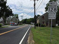
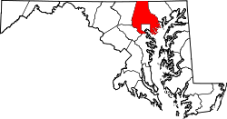
Butler is an unincorporated community in Baltimore County, Maryland, United States. It is bordered to the west by Glyndon, to the east by Sparks, to the south by Cockeysville and to the north by Upperco. It is often referred to as "Worthington Valley". For almost a century, Butler has served as home to many equestrian events, including the Grand Nationals and the Hunt Cup.
The history of the town is unknown. However, it has served as home to many of the state's oldest and wealthiest families for at least 150 years. Butler also serves as home to two very historic churches. St. John's Episcopal Church serves as the burial place for many of Maryland's politicians from the late 18th, 19th, and early 20th centuries. Also, Black Rock Primitive Baptist Church is the site of the historic "Black Rock Address" which occurred on September 28, 1832.
The community of Butler consists of a fire station, saddlery, liquor store, general store, post office (which is attached to the general store), a bike-and-coffee shop, and roughly five other smaller shops and businesses. At least two residences raise cattle, and many more raise and breed horses.
Most of the area's land is preserved and home to historic landmark houses/estates, making it one of the most picturesque places in Baltimore County. It forms a small commercial crossroads in the Western Run-Belfast Road Historic District. [2] The district was added to the National Register of Historic Places in 1979. [3]
Reisterstown is an unincorporated community and census-designated place in Baltimore County, Maryland, United States. As of the 2010 census, it had a population of 25,968.
Federal Hill is a neighborhood in Baltimore, Maryland, United States that lies just to the south of the city's central business district. Many of the structures are included in the Federal Hill Historic District, listed on the National Register of Historic Places in 1970. Other structures are included in the Federal Hill South Historic District, listed in 2003.
Hampden is a neighborhood located in northern Baltimore, Maryland, United States. Roughly triangular in shape, it is bounded to the east by the neighborhood Wyman Park, to the north by Roland Park at 40th and 41st Street, to the west by the Jones Falls Expressway, and to the south by the neighborhood Remington. The Homewood campus of the Johns Hopkins University is a short distance to the east.
Canton is a historic waterfront neighborhood in Baltimore, Maryland, United States. The neighborhood is along Baltimore's outer harbor in the southeastern section of the city, roughly 2 miles (3 km) east of Baltimore's downtown district and next to or near the neighborhoods of Patterson Park, Fell's Point, Highlandtown, and Brewers Hill.
"Pigtown", also known as "Washington Village" is a neighborhood in the southwest area of Baltimore, bordered by Martin Luther King Jr. Boulevard to the east, Monroe Street to the west, Russell Street to the south, and West Pratt Street to the north. The neighborhood acquired its name during the second half of the 19th century, when the area was the site of butcher shops and meat packing plants to process pigs transported from the Midwest on the B&O Railroad; they were herded across Ostend and Cross Streets to be slaughtered and processed.
Upton is a neighborhood in Baltimore City, Maryland, United States. The neighborhood is in the western section of the city, roughly between Fremont Avenue and McCulloh Street, extending from Dolphin Street to Bloom Street. Its principal thoroughfare is Pennsylvania Avenue.
Monkton is an unincorporated community in northern Baltimore County, Maryland, United States. It has a population of approximately 4,856 people. The community is 35 square miles (91 km2) in area, with approximately 138 inhabitants per square mile (53/km2). As an unincorporated area, Monkton has no legally defined boundaries, and its ZIP code (21111) includes a portion of adjacent Harford County.
The Dickeyville Historic District is a National Register of Historic Places-listed community located just inside the western edge of Baltimore City, Maryland, near the intersection of Interstates 70 and 695 and adjacent to Kernan Hospital. A small community of about 140 homes and a historic mill, the village is on the banks of the Gwynns Falls and lies at the start of the Gwynns Falls Trail, a 15-mile (24 km) walking and biking trail that is part of the Chesapeake Bay Gateways Network. The village includes two main roads, Wetheredsville Road and Pickwick Road, and three smaller lanes, Hillhouse Road, Tucker Lane and Sekots Road.
Woodwardville is an unincorporated community situated in western Anne Arundel County, Maryland, United States, containing 27 structures, 16 of which are historic and included in the Woodwardville Historic District, listed on the National Register of Historic Places in 2003. Most of the structures are located adjacent to Patuxent Road, which runs through the center of the community. On the north end of the district, a small street, 5th Avenue, runs west from Patuxent Road underneath the train tracks. Prior to the establishment of what would be later known as Fort George G. Meade in 1917, the road once continued on to Laurel. Three of the seven buildings along 5th Avenue are historic. Woodwardville's building stock consists principally of late-19th and early-20th century domestic architecture. Good examples of the Bungalow, Foursquare, Tudor Revival, and Queen Anne styles are present, as well as older traditional vernacular classifications such as the I-house. These older forms are supplemented by a handful of post-World War II era structures. Woodwardville also features several public or commercial buildings including a church, a former schoolhouse, the ruins of a store and storage or service buildings associated with the railroad. Many of Woodwardville's older buildings fell into decline following World War II, but in recent years, due to its close proximity to commuter rail service, Woodwardville has evolved into a bedroom community for persons working in Washington and Baltimore. Investment by new residents resulted in the restoration and renovation of many buildings which had formerly been in deteriorating condition. Despite the intense development a mile away in Piney Orchard, this quaint community retains its ability to communicate its historic qualities and distinct sense of place.
Johnsville is an unincorporated community in Frederick County, Maryland, United States. It is located approximately halfway between Libertytown and Union Bridge along Maryland Route 75. The Kitterman-Buckey Farm was listed on the National Register of Historic Places in 2005.
Leadenhall Street Baptist Church is a historic Baptist church located at Baltimore, Maryland, United States. It is a gable-front rectangular brick temple with simple Renaissance Revival detail. The original exterior wall surfaces have been covered with formstone on the main façade and stucco elsewhere. It features round-arched stained glass windows on each side bay. It was built in 1873, by Joseph Thomas & Son for the city's African American Baptists who were then centered in the old southwest area from the downtown business district of Baltimore in the "Sharp-Leadenhall" community in the old "South Baltimore" area. Nearby is its now famed revitalized "Inner Harbor" area of the old "Basin" for the harbor port.
Green Spring Valley Historic District is a national historic district near Stevenson in Baltimore County, Maryland, United States. It is a suburban area of Baltimore that acquires significance from the collection of 18th, 19th, and early 20th century buildings. The park-like setting retains a late 19th-early 20th century atmosphere. At the turn of the 20th century, the Maryland Hunt Cup and the Grand National Maryland steeplechase races were run over various parts of the valley. The Maryland Hunt Cup, which began as a competition between the Green Spring Valley Hunt and the Elkridge Hunt, traditionally started at Brooklandwood, the previous home of Charles Carrol of Carrollton with the finish across Valley Road at Oakdene, at that time the home of Thomas Deford, which remains a private residence
Rockland Historic District is a national historic district at Brooklandville, Baltimore County, Maryland, United States. It is located at the intersection of Old Court Road and Falls Road, where Old Court turns into Ruxton Road. There are 15 buildings in the area, including a general store, tavern, the shell of a blacksmith shop, a carriage house, several log buildings, a group of stone rowhouses, the Rockland Grist Mill, and an 18th-century dwelling. It is one of the surviving examples of a small, quiet, sylvan community of the early 19th century.
Western Run–Belfast Road Historic District is a national historic district at Lutherville, Baltimore County, Maryland, United States. It is a largely agricultural area was first settled in the 18th century and is a natural extension of the Worthington Valley Historic District. It includes the village of Butler forming a small commercial crossroads with its general store, post office, and firehouse.
Worthington Valley Historic District is a national historic district in Reisterstown, Baltimore County, Maryland, United States. It is a largely rural district where the earliest standing structures date from the very end of the 18th century. Horse breeding and racing is a very large and lucrative business in the valley. Since 1922, Snow Hill and Worthington Farms have been the scene of the Maryland Hunt Cup Steeplechase. Located next to it is the Western Run–Belfast Road Historic District.
Glyndon is an unincorporated community in Baltimore County, Maryland, United States. Founded in 1871 by Dr. Charles A. Leas, the village is located in the northwest section of Baltimore County and is primarily a residential suburb of metropolitan Baltimore City. Glyndon is listed on the National Register of Historic Places (1973) and on the Maryland Inventory of Historic Properties (1973); the Glyndon Historic District was also designated as the first historic district in Baltimore County (1981).
East Monument Historic District or Little Bohemia, is a national historic district in Baltimore, Maryland. It is a large residential area with a commercial strip along East Monument Street. It comprises approximately 88 whole and partial blocks. The residential area is composed primarily of rowhouses that were developed, beginning in the 1870s, as housing for Baltimore's growing Bohemian (Czech) immigrant community. During the late 19th and early 20th centuries the neighborhood was the heart of the Bohemian community in Baltimore. The Bohemian National Parish of the Roman Catholic Church, St. Wenceslaus, is located in the neighborhood. The historic district includes all of McElderry Park and Milton-Montford, most of Middle East and Madison-Eastend, and parts of Ellwood Park.
The Bare Hills Historic District encompasses a residential area north of Baltimore, Maryland, in Baltimore County, which had industrial beginnings before being transformed into a suburb of the city. The district includes Lake Roland Park as well as a cluster of largely vernacular dwellings between the park and Falls Turnpike that was built mainly in the 19th century.
Midtown-Edmondson is a mixed-use neighborhood in western Baltimore City developed mostly between the 1880s and the 1910s. The neighborhood is mainly composed of residential rowhouses, with a mixed-used business district along Edmondson Avenue, and industrial warehouses and buildings dotted along the CSX railroads that bound its western edge.