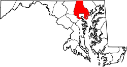
Rossville, Maryland | |
---|---|
Coordinates: 39°21′21″N76°28′43″W / 39.35583°N 76.47861°W | |
Country | United States |
State | Maryland |
County | Baltimore |
Area | |
• Total | 5.40 sq mi (13.99 km2) |
• Land | 5.38 sq mi (13.93 km2) |
• Water | 0.02 sq mi (0.06 km2) |
Elevation | 43 ft (13 m) |
Population (2020) | |
• Total | 16,029 |
• Density | 2,979.92/sq mi (1,150.51/km2) |
Time zone | UTC−5 (Eastern (EST)) |
• Summer (DST) | UTC−4 (EDT) |
FIPS code | 24-68700 |
GNIS feature ID | 0591188 |
Rossville is an unincorporated community and census-designated place in Baltimore County, Maryland, United States. The population was 15,147 at the 2010 census. [2]
Rossville is located at 39°21′21″N76°28′43″W / 39.35583°N 76.47861°W (39.355897, −76.478732). [3]
According to the United States Census Bureau, the CDP has a total area of 5.4 square miles (14 km2), of which 5.4 square miles (14 km2) is land and 0.18% is water.
Census | Pop. | Note | %± |
---|---|---|---|
1980 | 8,646 | — | |
1990 | 9,492 | 9.8% | |
2000 | 11,515 | 21.3% | |
2010 | 15,147 | 31.5% | |
2020 | 16,029 | 5.8% | |
U.S. Decennial Census [4] |
As of the census [5] of 2000, there were 11,515 people, 4,811 households, and 2,819 families living in the CDP. The population density was 2,132.5 inhabitants per square mile (823.4/km2). There were 5,157 housing units at an average density of 955.1 per square mile (368.8/km2). The racial makeup of the CDP was 70.60% White, 21.88% African American, 0.29% Native American, 4.26% Asian, 0.01% Pacific Islander, 1.24% from other races, and 1.71% from two or more races. Hispanic or Latino of any race were 2.86% of the population.
There were 4,811 households, out of which 30.2% had children under the age of 18 living with them, 40.3% were married couples living together, 13.4% had a female householder with no husband present, and 41.4% were non-families. 31.4% of all households were made up of individuals, and 4.0% had someone living alone who was 65 years of age or older. The average household size was 2.34 and the average family size was 2.98.
In the CDP, the population was spread out, with 23.0% under the age of 18, 11.4% from 18 to 24, 36.7% from 25 to 44, 19.8% from 45 to 64, and 9.1% who were 65 years of age or older. The median age was 32 years. For every 100 females, there were 95.2 males. For every 100 females age 18 and over, there were 91.2 males.
The median income for a household in the CDP was $47,545, and the median income for a family was $57,974. Males had a median income of $37,079 versus $30,006 for females. The per capita income for the CDP was $22,608. About 3.8% of families and 4.9% of the population were below the poverty line, including 4.4% of those under age 18 and 6.0% of those age 65 or over.
Seldovia Village is a census-designated place (CDP) in Kenai Peninsula Borough, Alaska, United States. At the 2010 census the population was 165, up from 144 in 2000. Seldovia Village is not to be confused with the adjacent city of Seldovia.
Brooklyn Park is a census-designated place (CDP) in Anne Arundel County, Maryland, United States. The population was 14,373 at the 2010 census.
Ferndale is a census-designated place (CDP) in Anne Arundel County, Maryland, United States. At the 2010 census, the population was 16,746.
Riviera Beach is a census-designated place in Anne Arundel County, Maryland, United States. The population was 12,677 at the 2010 U.S. census.
South Gate was a census-designated place (CDP) in Anne Arundel County, Maryland, United States, for the 2000 census, at which time its population was 28,672. It was added primarily to the Glen Burnie CDP for the 2010 census.
Edgemere is an unincorporated community and census-designated place in Baltimore County, Maryland, United States. The population was 8,669 at the 2010 census. Founded in 1899 as Edgemere being renamed from previous name "Fitzell". Meeting held at the Fitzell Farm which was situated where the old Rheem plant was located.
Essex is an unincorporated community and census-designated place in Baltimore County, Maryland, United States. Essex has a long history dating back to 1909. The population was 39,262 at the 2010 census and is growing in population each year. The town hosts beaches, parks, wetlands, a courthouse, and a museum which was once a school, courthouse, jail, and firehouse. The town has a strip of shops known as the business district on Eastern boulevard starting from Virginia avenue to Marlyn avenue. The business district originally started from Mace avenue to Marlyn Avenue. Its largest shopping center, Middlesex, was built in 1955 which once had a department store Montgomery Ward and food fair as the anchors of the shopping center.
Lochearn is an unincorporated community and census-designated place in Baltimore County, Maryland, United States, located immediately to the west of the City of Baltimore. Per the 2020 census, the population was 25,511.
Rosedale is an unincorporated community and census-designated place in Baltimore County, Maryland, United States. The population was 19,257 at the 2010 United States Census.
Fallston is a census-designated place (CDP) in Harford County, Maryland, United States. The population was 8,958 at the 2010 census, up from 8,427 in 2000. Fallston is a semi-rural community consisting mostly of farms and suburban-like developments.
Perryman is an unincorporated community and census-designated place (CDP) in Harford County, Maryland, United States. The population was 2,342 at the 2010 census.
Pleasant Hills is a census-designated place (CDP) in Harford County, Maryland, United States. The population was 3,379 at the 2010 census, up from 2,851 in 2000. There is no post office with the designation "Pleasant Hills"; most of the residents have either Fallston or Kingsville addresses and consider themselves as belonging to those communities.
Savage-Guilford was a census-designated place (CDP) in Howard County, Maryland, United States, for the 2000 U.S. Census, at which time its population was 12,918. It consisted of the unincorporated community communities of Savage and Guilford. At the 2010 U.S. Census, the area was re-delineated as the Savage CDP.
Ashton-Sandy Spring is a census-designated place (CDP) in Montgomery County, Maryland, United States. The CDP is designated to include the two unincorporated communities of Ashton and Sandy Spring, as well as the smaller community of Brinklow. It had a population of 5,746 as of the 2020 census.
Cloverly is an unincorporated town and census-designated place in Montgomery County, Maryland, United States. Its population was 15,285 as of the 2020 census.
Fairland is a census-designated place and an unincorporated area in Montgomery County, Maryland, United States. It had a population of 25,396 per the 2020 census.
South Laurel is an unincorporated area and census-designated place (CDP) in Prince George's County, Maryland, United States. Per the 2020 census, the population was 29,602.
Springdale is an unincorporated area and census-designated place (CDP) in Prince George's County, Maryland, United States. Per the 2020 census, the population was 5,301.
West Laurel is an unincorporated area and census-designated place (CDP) in Prince George's County, Maryland, United States. Per the 2020 census, the population was 4,428.
Calverton is an unincorporated area and census-designated place located on the boundary between Montgomery and Prince George's counties, Maryland, in the United States. At the 2020 census, it had a population of 17,316.