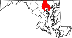
Hydes, Maryland

Last updated

Hydes, Maryland
Hydes Md.jpg
Hydes Post Office (foreground) and the former Ma & Pa RR station and store
USA Maryland location map.svg
Red pog.svg
Hydes, Maryland
Location within the State of Maryland
Usa edcp location map.svg
Red pog.svg
Hydes, Maryland
Hydes, Maryland (the United States)
Coordinates: 39°29′02″N76°29′36″W / 39.48389°N 76.49333°W / 39.48389; -76.49333
Country Flag of the United States.svg United States
State Flag of Maryland.svg  Maryland
County Flag of Baltimore County, Maryland.svg Baltimore
Time zone UTC-5 (Eastern (EST))
  Summer (DST) UTC-4 (EDT)
ZIP codes
21082

Hydes is an unincorporated community in Baltimore County, Maryland, United States. [1] It is located in the Long Green Valley. The USPS has assigned Hydes the postal code 21082. Saint John the Evangelist church is located in Hydes and is the oldest Roman Catholic Church in Baltimore County. Until 1958, this community was served by the Maryland and Pennsylvania Railroad at milepost 16.8. It is also home to several wineries, including Boordy and Dejon Vineyards.

Hydes is named for Samuel N. Hyde, an agronomist who developed a strain known as "Egyptian" sweet corn, canned by the F.B. Jenkins canning operation of Hydes.

This is an image from a paper label for a can of S N Hyde Egyptian Sweet Corn.This can label was printed prior to 1900 and is in public domain due to its age. This can label was found under the front porch of the house that belonged to the F B Jenkins family, producers of the brand of canned "Egyptian Sweet Corn". Hydes Corn lable-landscape.jpg
This is an image from a paper label for a can of S N Hyde Egyptian Sweet Corn.This can label was printed prior to 1900 and is in public domain due to its age. This can label was found under the front porch of the house that belonged to the F B Jenkins family, producers of the brand of canned "Egyptian Sweet Corn".

Related Research Articles

<span class="mw-page-title-main">Anne Arundel County, Maryland</span> County in Maryland, United States

Anne Arundel County, also notated as AA or A.A. County, is located in the U.S. state of Maryland. As of the 2020 United States census, its population was 588,261, an increase of just under 10% since 2010. Its county seat is Annapolis, which is also the capital of the state. The county is named for Anne Arundell, Lady Baltimore, a member of the ancient family of Arundells in Cornwall, England, and the wife of Cecilius Calvert, 2nd Baron Baltimore (1605–1675), founder and first lord proprietor of the colony Province of Maryland.

Germantown or German Town may refer to:

<span class="mw-page-title-main">Linthicum, Maryland</span> Census-designated place in Maryland, United States

Linthicum is a census-designated place (CDP) and unincorporated community in Anne Arundel County, Maryland, United States. The population was 10,324 at the 2010 census. It is located directly north of Baltimore–Washington International Thurgood Marshall Airport (BWI).

<span class="mw-page-title-main">Catonsville, Maryland</span> Census-designated place in Maryland, United States

Catonsville is a census-designated place (CDP) in Baltimore County, Maryland. The population was 44,701 at the 2020 US Census. The community is a streetcar suburb of Baltimore along the city's western border. The town is known for its proximity to the Patapsco River and Patapsco Valley State Park, making it a regional mountain biking hub. The town is also notable as a local hotbed of music, earning it the official nickname of "Music City, Maryland." Catonsville contains the majority of the University of Maryland, Baltimore County (UMBC), a major public research university with close to 14,000 students.

<span class="mw-page-title-main">Reisterstown, Maryland</span> Census-designated place in Maryland, United States

Reisterstown is an unincorporated community and census-designated place in Baltimore County, Maryland, United States. As of the 2010 census, it had a population of 25,968.

<span class="mw-page-title-main">Towson, Maryland</span> Census-designated place in Maryland, United States

Towson is an unincorporated community and a census-designated place in Baltimore County, Maryland, United States. The population was 55,197 as of the 2010 census. It is the county seat of Baltimore County and the second-most populous unincorporated county seat in the United States.

<span class="mw-page-title-main">Woodlawn, Baltimore County, Maryland</span> Place in Maryland, United States

Woodlawn is an unincorporated community and census-designated place in Baltimore County, Maryland. Per the 2020 census, the population was 39,986. It is home to the headquarters of the Social Security Administration (SSA) and the Centers for Medicare and Medicaid Services (CMS). It is bordered by Catonsville on the south, by the Patapsco River and Howard County on the west, by Randallstown and Lochearn to the north, and by the City of Baltimore to the east. Parts of Woodlawn are sometimes informally referred to as Security, Maryland, due to the importance of the SSA's headquarters as well as nearby Security Boulevard and Security Square Mall.

<span class="mw-page-title-main">Joppatowne, Maryland</span> Census-designated place in Maryland, United States

Joppatowne is a census-designated place in southwestern Harford County, Maryland, United States. Serving as a bedroom community for nearby Baltimore, it was established in 1961 as a planned unit development (PUD). The population was 12,616 at the 2010 census, up from 11,391 in 2000.

<span class="mw-page-title-main">Elkridge, Maryland</span> Census-designated place in Maryland, United States of America

Elkridge is an unincorporated community and census-designated place (CDP) in Howard County, Maryland, United States. The population was 15,593 at the 2010 census. Founded early in the 18th century, Elkridge is adjacent to two other counties, Anne Arundel and Baltimore.

<span class="mw-page-title-main">Georgetown (Washington, D.C.)</span> Place in the United States

Georgetown is a historic neighborhood and commercial district of Washington, D.C., in Northwest D.C., situated along the Potomac River. Founded in 1751 in the Province of Maryland, the port of Georgetown predated the establishment of the federal district and the City of Washington by 40 years. Incorporated into the District of Columbia, Georgetown remained a separate municipality until 1871 when the United States Congress created a new consolidated government for the whole District. A separate act, passed in 1895, specifically repealed Georgetown's remaining local ordinances and renamed Georgetown's streets to conform with those in the City of Washington.

<span class="mw-page-title-main">Oella, Maryland</span> Historic district in Maryland, United States

Oella is a mill town on the Patapsco River in western Baltimore County, Maryland, United States, located between Catonsville and Ellicott City. It is a 19th-century village of millworkers' homes.

Muirkirk is an unincorporated community in northern Prince George's County, Maryland, United States, located between Baltimore and Washington in the central part of the state.

<span class="mw-page-title-main">Lansdowne, Maryland</span> Census-designated place in Maryland, United States

Lansdowne is a census-designated place in southern Baltimore County, Maryland, United States, located just south of Baltimore. As of the 2010 census, it had a population of 8,409. At the 2000 census and earlier, the area was delineated as part of the Lansdowne-Baltimore Highlands CDP.

Joppa is a former colonial town and current planning region of Harford County, Maryland, United States. Joppa was founded as a British settlement on the Gunpowder River in 1707 and designated as the third county seat of Baltimore County in 1712. The original boundaries of Baltimore County were defined in 1659 and contained all of modern day Baltimore County, Baltimore City, Harford and Cecil counties and parts of Howard, Carroll, Anne Arundel and Kent counties. The settlement was named for the Biblical town of Jaffa in the ancient Holy Land of modern-day Israel. Joppa's harbor began to silt in due to clearcutting and farming upriver and coupled with multiple outbreaks of diseases such as smallpox and malaria, the county seat was moved to the growing, deep water port of Baltimore in 1768. Joppa's population would decline rapidly thereafter and businesses left for more prosperous environments in the new Baltimore Town.

<span class="mw-page-title-main">Ilchester, Maryland</span> Census-designated place in Maryland

Ilchester is an unincorporated community and census-designated place in Howard County, Maryland, United States. The population was 23,476 at the 2010 census. It was named after the village of Ilchester in the English county of Somerset.

Bradshaw is an unincorporated community in Baltimore County, Maryland, United States, located southeast of Kingsville.

<span class="mw-page-title-main">East Monument Historic District</span> Historic district in Maryland, United States

East Monument Historic District or Little Bohemia, is a national historic district in Baltimore, Maryland. It is a large residential area with a commercial strip along East Monument Street. It comprises approximately 88 whole and partial blocks. The residential area is composed primarily of rowhouses that were developed, beginning in the 1870s, as housing for Baltimore's growing Bohemian (Czech) immigrant community. During the late 19th and early 20th centuries the neighborhood was the heart of the Bohemian community in Baltimore. The Bohemian National Parish of the Roman Catholic Church, St. Wenceslaus, is located in the neighborhood. The historic district includes all of McElderry Park and Milton-Montford, most of Middle East and Madison-Eastend, and parts of Ellwood Park.

TB is an unincorporated community in Prince George's County, in the U.S. state of Maryland, near the intersection of highways MD 5 and US 301.

Louis S. Diggs was an African-American writer and historian specializing in the African-American history of Baltimore County, Maryland. As a chronicler of the county's African-American legacy, his work illuminates the historic past of its Black communities. In addition to social history, Diggs has published on Baltimore African-American military records from the American Civil War and the Maryland Army National Guard.

References

  1. "Geographic Names Information System". Hydes (Populated Place). U.S. Geological Survey. January 29, 2009.