Mechanicsville, Maryland

Last updated

Mechanicsville, Maryland
Amish parking lot Mechanicsville Maryland.jpg
Amish horse and buggy parking space, July 2016.
USA Maryland location map.svg
Red pog.svg
Mechanicsville
Usa edcp location map.svg
Red pog.svg
Mechanicsville
Coordinates: 38°26′34″N76°44′38″W / 38.44278°N 76.74389°W / 38.44278; -76.74389
Country Flag of the United States.svg United States
State Flag of Maryland.svg  Maryland
County St. Mary's
Area
[1]
  Total5.20 sq mi (13.46 km2)
  Land5.19 sq mi (13.44 km2)
  Water0.01 sq mi (0.01 km2)
Elevation
157 ft (48 m)
Population
 (2020)
  Total1,673
  Density322.35/sq mi (124.46/km2)
Time zone UTC−5 (Eastern (EST))
  Summer (DST) UTC−4 (EDT)
ZIP code
20659
Area code(s) 301, 240
GNIS feature ID594822 [2]

Mechanicsville is an unincorporated community and census-designated place in St. Mary's County, Maryland, United States. [2] It is adjacent to the community of Charlotte Hall, which is known for its agriculture, Amish population, large farmers' market/flea market and the Maryland Veterans Home. Mechanicsville has many small businesses and restaurants along Maryland Route 5 and Maryland Route 235. The community is served by the St. Mary's County Public Schools, including Chopticon High School. At the 2010 census, Mechanicsville had a population of 1,528. [3]

Contents

The Amish community in the Mechanicsville area consists of eight church districts and approximately 1,000 people. The Amish first came to the area in 1940. There is also an Old Order Mennonite community in the Mechanisville area. In recent years, increasing development has threatened the Amish community. [4]

History

Part of the area was first settled in the 1660s by early Maryland colonists who were tobacco planters. They established some farms not far from the Patuxent river. In 1819, Cremona Farm, a 750-acre estate and plantation was built in the same location. In about 1850, "Mechanicsville Village" was established on the historic Three Notch Trail. The name "Mechanicsville" is believed to have come from the word "Mechanic" because the area became a center for blacksmiths and other craftsmen. [5] In those days "Mechanic" meant a skilled tradesperson who worked by hands.

There was an old railway that passed through Mechanicsville and local residents joined other St. Mary's County residents in purchasing it and saving it from being scrapped in 1918. Farm goods moved along the railroad on train cars and passenger service continued until about 1928. By that time county roads had improved and the railway began to fall out of use. [5]

The Amish community was established in Mechanicsville in 1940. [6] It is a Lancaster County, Pennsylvania, daughter settlement. [5] The Amish left Lancaster County because of a dispute with the state of Pennsylvania over education practices. The Amish people had their own system of one room schoolhouses there and a school year that better accommodated the farm season. But Pennsylvania tried to force them into the state school system. [6] Maryland provided a place for the Lancaster Amish to escape these pressures and, as historian Karen Johnson-Weiner described, avoid “what they saw as a threat to their religious identity”. [5] Many Amish left at the time and one large group moved to Mechanicsville, Maryland. [5] Today, the Amish settlement in Mechanicsville is one of the largest Lancaster daughter communities. [6]

Demographics

Traditional local food, crabcake sandwich and garlic mash potatoes at the Foxy Fish restaurant in Mechanicsville 2014 02.FoxyFish.Mechanicsville.MD.17February2014 - Flickr - Elvert Barnes.jpg
Traditional local food, crabcake sandwich and garlic mash potatoes at the Foxy Fish restaurant in Mechanicsville 2014
Tobacco farm in Mechanicsville in 1942 Mechanicsville (vicinity), St. Mary's County, Maryland 8c36442v.jpg
Tobacco farm in Mechanicsville in 1942
Engine 5, of the Washington, Brandywine and Point Lookout Railroad, picture taken in Mechanicsville in 1934 WB&PL Engine 5.jpg
Engine 5, of the Washington, Brandywine and Point Lookout Railroad, picture taken in Mechanicsville in 1934
Cremona Farm in Mechanicsville, built in 1819. Cremona, main house, front (21441768149).jpg
Cremona Farm in Mechanicsville, built in 1819.

2020 US federal census

In 2020, the population of Mechanicsville was 1,673 in 628 households. [7]

Population by race [7]

Ethnic heritage
Irish 33.3%, German 32.4%, French (except Basque) 16.6%, English 13.9%, Polish 9.5%, African-American 5.9%, Italian 5.4%, Scottish 1.5%, Norwegian 0.8%, American Indian 0.5%. [7]

Income and education [7]

Historical population
CensusPop.Note
1930 1,734
1940 1,696−2.2%
2010 1,528
2020 1,6739.5%
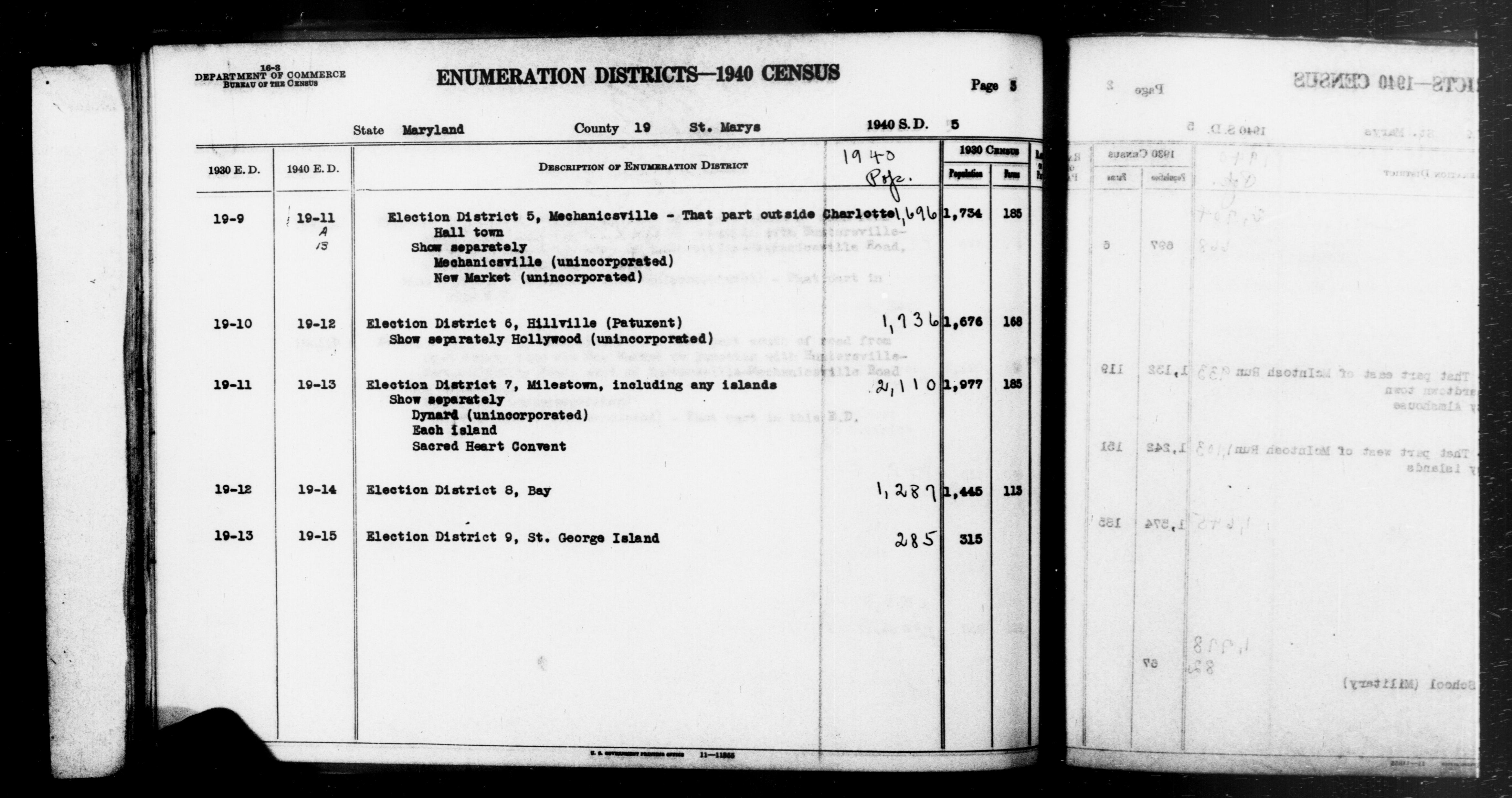
US Federal 2020 Census
(Includes 2010 Census) [7]
St. Mary's County 1940 Census
(includes 1930 Census data) [8]

Notable people

Climate

The climate in this area is characterized by hot, humid summers and generally cool to cold winters. According to the Köppen Climate Classification system, Mechanicsville has a humid subtropical climate, abbreviated "Cfa" on climate maps. [9] In the spring and summer the area gets frequent thunderstorms, many severe, [10] and on rare occasion, tornadoes. [11] From June 2021 to June 2022 Mechanicsville had 41 severe thunderstorm warnings. [10]

2022 Tornado

On June 8, 2022, a severe thunderstorm developed a tornado that touched down in Mechanicsville, damaging farm buildings and a residential home, uprooting some trees and snapping other tree trunks. [12]

Monthly weather averages

Climate data for Mechanicsville, Maryland (1991–2020 normals, extremes 1974-present)
MonthJanFebMarAprMayJunJulAugSepOctNovDecYear
Record high °F (°C)81
(27)
81
(27)
91
(33)
94
(34)
94
(34)
99
(37)
103
(39)
101
(38)
100
(38)
90
(32)
82
(28)
80
(27)
103
(39)
Mean maximum °F (°C)67
(19)
69
(21)
78
(26)
87
(31)
88
(31)
92
(33)
94
(34)
92
(33)
88
(31)
81
(27)
75
(24)
67
(19)
95
(35)
Mean daily maximum °F (°C)44.2
(6.8)
47.6
(8.7)
55.9
(13.3)
67.3
(19.6)
73.7
(23.2)
81.5
(27.5)
85.3
(29.6)
83.3
(28.5)
76.7
(24.8)
66.1
(18.9)
57.3
(14.1)
48.1
(8.9)
65.6
(18.7)
Daily mean °F (°C)34.5
(1.4)
36.9
(2.7)
44.2
(6.8)
54.9
(12.7)
62.9
(17.2)
71.2
(21.8)
75.6
(24.2)
73.8
(23.2)
67.2
(19.6)
55.9
(13.3)
46.4
(8.0)
38.3
(3.5)
55.2
(12.9)
Mean daily minimum °F (°C)24.8
(−4.0)
26.2
(−3.2)
32.6
(0.3)
42.5
(5.8)
52.0
(11.1)
60.9
(16.1)
65.9
(18.8)
64.2
(17.9)
57.7
(14.3)
45.7
(7.6)
35.5
(1.9)
28.6
(−1.9)
44.7
(7.1)
Mean minimum °F (°C)9
(−13)
13
(−11)
18
(−8)
29
(−2)
38
(3)
49
(9)
57
(14)
56
(13)
45
(7)
32
(0)
23
(−5)
15
(−9)
6
(−14)
Record low °F (°C)−7
(−22)
−9
(−23)
5
(−15)
21
(−6)
30
(−1)
40
(4)
45
(7)
41
(5)
35
(2)
20
(−7)
14
(−10)
0
(−18)
−9
(−23)
Average precipitation inches (mm)3.29
(84)
2.97
(75)
4.24
(108)
3.31
(84)
4.32
(110)
4.19
(106)
4.57
(116)
4.84
(123)
4.87
(124)
4.18
(106)
3.34
(85)
3.99
(101)
48.11
(1,222)
Average snowfall inches (cm)5.0
(13)
6.2
(16)
1.8
(4.6)
0.1
(0.25)
0
(0)
0
(0)
0
(0)
0
(0)
0
(0)
0
(0)
0
(0)
2.0
(5.1)
15.1
(38)
Average extreme snow depth inches (cm)4
(10)
4
(10)
2
(5.1)
0
(0)
0
(0)
0
(0)
0
(0)
0
(0)
0
(0)
0
(0)
0
(0)
2
(5.1)
6
(15)
Average precipitation days (≥ 0.01 in)109101011101099889115
Average snowy days (≥ 0.1 in)2210000000015
Source: NOAA [13]

Related Research Articles

<span class="mw-page-title-main">Oakland, Maryland</span> Town in Maryland, United States

Oakland is a town in and the county seat of Garrett County, Maryland, United States. The population was 1,851 at the 2020 census. It is situated only miles from the source of the Potomac River, which flows directly into Chesapeake Bay. It is also near the Wisp Resort at Deep Creek Lake, a major ski resort for many Marylanders and other visitors. Oakland is part of the Pittsburgh media market.

<span class="mw-page-title-main">Cecil County, Maryland</span> County in the United States

Cecil County is a county located in the U.S. state of Maryland at the northeastern corner of the state, bordering both Pennsylvania and Delaware. As of the 2020 census, the population was 103,725. The county seat is Elkton.

<span class="mw-page-title-main">Dover, Delaware</span> Capital city of Delaware, United States

Dover is the capital and second-most populous city of the U.S. state of Delaware. It is also the county seat of Kent County and the principal city of the Dover metropolitan statistical area, which encompasses all of Kent County and is part of the Philadelphia–Wilmington–Camden, PA–NJ–DE–MD, combined statistical area. It is located on the St. Jones River in the Delaware River coastal plain. It was named by William Penn for Dover in Kent, England. As of 2020, its population was 39,403.

<span class="mw-page-title-main">St. Mary's County, Maryland</span> County in Maryland, United States

St. Mary's County, established in 1637, is a county located in the U.S. state of Maryland. As of the 2020 census, the population was 113,777. Its county seat is Leonardtown. The name is in honor of Mary, the mother of Jesus. St. Mary's County comprises the California-Lexington Park, Maryland Metropolitan Statistical Area, which also is included in the Washington-Baltimore-Arlington, DC-MD-VA-WV-PA Combined Statistical Area. It is part of the Southern Maryland region. The county was the home to the first Maryland Colony, and the first capital of the Colony of Maryland. Settled by English Catholics, it is considered to be the birthplace of religious freedom in North America, at a time when the British colonies were settled primarily by Protestants. The county is home to the Patuxent River Naval Air Station and St. Mary's College of Maryland. Traditionally, St. Mary's County has been known for its unique and historic culture of Chesapeake Bay tidewater farming, fishing, and crabbing communities. But with the advent of the military bases, growth of an extensive defense contractor presence, and the growth of St. Mary's College of Maryland, as well as increasing numbers of long-distance Washington, D.C. commuters, it has been undergoing a decades-long transformation which has seen the county's population double since 1970.

<span class="mw-page-title-main">Lancaster County, Pennsylvania</span> County in Pennsylvania, United States

Lancaster County, sometimes nicknamed the Garden Spot of America or Pennsylvania Dutch Country, is a county in the Commonwealth of Pennsylvania. It is located in the south central part of Pennsylvania. As of the 2020 census, the population was 552,984, making it Pennsylvania's sixth-most populous county. Its county seat is Lancaster. Lancaster County comprises the Lancaster, Pennsylvania metropolitan statistical area.

<span class="mw-page-title-main">Lancaster, Pennsylvania</span> City in Pennsylvania, United States

Lancaster is a city in and the county seat of Lancaster County, Pennsylvania, and one of the oldest inland cities in the United States. With a population of 58,039 at the 2020 census, it is the tenth-most-populous city in the state. The Lancaster metropolitan area population is 552,984, making it the second largest in the South Central Pennsylvania area.

<span class="mw-page-title-main">Kent County, Delaware</span> County in Delaware, United States

Kent County is a county located in the central part of the U.S. state of Delaware. As of the 2020 census, the population was 181,851, making it the least populous county in Delaware. The county seat is Dover, the state capital of Delaware. It is named for Kent, an English county.

<span class="mw-page-title-main">Dauphin County, Pennsylvania</span> County in Pennsylvania, United States

Dauphin County is a county in the Commonwealth of Pennsylvania. As of the 2020 census, the population was 286,401. The county seat is Harrisburg, Pennsylvania's state capital and ninth-most populous city. The county was created on March 4, 1785, from part of Lancaster County and was named after Louis Joseph, Dauphin of France, the first son of King Louis XVI.

<span class="mw-page-title-main">Williamson County, Illinois</span> County in Illinois, United States

Williamson County is a county in Southern Illinois. At the 2020 census, it had a population of 67,153. The largest city and county seat is Marion.

<span class="mw-page-title-main">Arthur, Illinois</span> Village in Illinois, United States

Arthur is a village in Douglas and Moultrie counties in Illinois, with Arthur's primary street, Vine Street, being the county line. The population was 2,231 at the 2020 census. The Arthur area is home to the largest and oldest Amish community in Illinois, which was founded in the 1860s.

<span class="mw-page-title-main">Nappanee, Indiana</span> City in Indiana, United States

Nappanee is a city in Elkhart and Kosciusko counties in the U.S. state of Indiana. The population was 6,648 as of the 2010 U.S. Census and had grown to 6,913 by the 2020 U.S. Census. The name Nappanee is thought to mean "flour" in the Algonquian language.

<span class="mw-page-title-main">Prince Frederick, Maryland</span> Census-designated place in Maryland, United States

Prince Frederick is an unincorporated community and census-designated place (CDP) in Calvert County, Maryland, United States. As of the 2020 census, the population of Prince Frederick was 3,226, up from 2,538 in 2010. It is the county seat of Calvert County.

<span class="mw-page-title-main">Westminster, Maryland</span> City in Maryland, United States

Westminster is a city in northern Maryland, United States. It is the seat of Carroll County. The city's population was 19,960 at the 2020 census. Westminster is an outlying community within the Baltimore-Towson, MD MSA, which is part of a greater Washington-Baltimore-Northern Virginia, DC-MD-VA-WV CSA.

<span class="mw-page-title-main">La Plata, Maryland</span> Town in Maryland, United States

La Plata is a town in Charles County, Maryland, United States. The population was 10,159 at the 2020 census. It is the county seat of Charles County.

<span class="mw-page-title-main">Waldorf, Maryland</span> Census-designated place in Maryland, United States

Waldorf is a census-designated place in Charles County, Maryland, United States. Located 23 miles (37 km) south-southeast of Washington, D.C., Waldorf is part of Southern Maryland. Its population was 81,410 at the 2020 census, making it the fourth-most populous community in the state. Waldorf has experienced dramatic growth, increasing its population 16-fold from fewer than 5,000 residents in 1980 to its current population. It is now the largest commercial and residential area in Southern Maryland as well as a major suburb in the Washington metropolitan area.

<span class="mw-page-title-main">Damascus, Maryland</span> Census-designated place in Maryland, United States

Damascus is a census-designated place and an unincorporated area in Montgomery County, Maryland, United States. In the early 20th century, there existed an incorporated municipality lasting a quarter century. It had a population of 17,224 as of the 2020 census. Damascus is located at the intersection of two major roads in upper Montgomery County: Ridge Road and Damascus Road.

<span class="mw-page-title-main">Charlotte Hall, Maryland</span> CDP in Maryland, United States

Charlotte Hall is a census-designated place (CDP) in Charles and St. Mary's counties, Maryland, United States. The population was 1,420 at the 2010 census. The Maryland Veterans Home for disabled veterans, including a U.S. Veterans Affairs clinic, is located on the site of the former Charlotte Hall Military Academy. The Academy site was declared the Charlotte Hall Historic District, and listed on the National Register of Historic Places in 1975. Since 1940, a sizable Amish farming community has existed nearby, along with a farmers' market and large flea market complex on Maryland Route 5, which is also the site of numerous strip-mall businesses continuing into the adjacent community of Mechanicsville.

<span class="mw-page-title-main">Lexington Park, Maryland</span> CDP in Maryland, United States

Lexington Park is a census-designated place (CDP) in St. Mary's County, Maryland, United States, and the principal community of the Lexington Park, Maryland Micropolitan Statistical Area. The population was 11,626 at the 2010 census.

Norton Townshend Dodge was an American economist and educator who amassed one of the largest collections of Soviet-era art outside the Soviet Union.

<span class="mw-page-title-main">Amish in Maryland</span>

The Amish in Maryland maintain a small but well-established population. There have been four Amish communities in the history of Maryland, three of which currently exist. The three Amish communities of Maryland are located in Western Maryland, Southern Maryland, and on the Eastern Shore. Historically, an Amish community also existed in rural Baltimore County, but had disappeared by the 1950s. The Amish communities of Maryland are all inhabited by the descendants of Amish migrants from Pennsylvania. In 2018, Maryland had an Amish population of around 1,575 people.

References

  1. "2020 U.S. Gazetteer Files". United States Census Bureau. Retrieved April 26, 2022.
  2. 1 2 "Mechanicsville". Geographic Names Information System . United States Geological Survey, United States Department of the Interior.
  3. https://www.census.gov [ not specific enough to verify ]
  4. "Maryland Amish". Amish America. March 2011. Retrieved October 6, 2017.
  5. 1 2 3 4 5 Fisher, Bernard (June 16, 2019). "THE HISTORICAL MARKER DATABASE". HMdb.org. J. J. Prats. Retrieved June 12, 2022.
  6. 1 2 3 Wesner, Erik (October 7, 2010). "The Amish of Mechanicsville, Maryland". Amish America. Retrieved June 12, 2022.
  7. 1 2 3 4 5 "Mechanicsville CDP, Maryland, 2020 Census". US Census Bureau. 2020. Retrieved June 12, 2022.
  8. "Enumeration Districts - 1940 Census: Maryland, St. Mary's County". Wikimedia Commons: Photo of St. Mary's County 1940 Census records. Department of Commerce, Bureau of the Census. July 24, 2019. Retrieved June 12, 2022.
  9. Climate Summary for Mechanicsville, Maryland
  10. 1 2 "Hail Map for Mechanicsville, MD". Interactive Hail Maps. June 12, 2022. Retrieved June 12, 2022.
  11. "Tornado Touchdown Confirmed In Mechanicsville". National Weather Service. June 10, 2022. Retrieved June 6, 2022.
  12. "Tornado Touchdown Confirmed In Mechanicsville". National Weather Service. June 10, 2022. Retrieved June 6, 2022.
  13. "NowData – NOAA Online Weather Data". National Oceanic and Atmospheric Administration . Retrieved May 28, 2022.