Related Research Articles
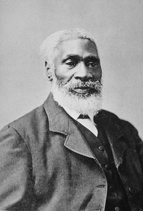
Josiah Henson was an author, abolitionist, and minister. Born into slavery, in Port Tobacco, Charles County, Maryland, he escaped to Upper Canada in 1830, and founded a settlement and laborer's school for other fugitive slaves at Dawn, near Dresden, in Kent County, Upper Canada, of Ontario. Henson's autobiography, The Life of Josiah Henson, Formerly a Slave, Now an Inhabitant of Canada, as Narrated by Himself (1849), is believed to have inspired the title character of Harriet Beecher Stowe's 1852 novel Uncle Tom's Cabin (1852). Following the success of Stowe's novel, Henson issued an expanded version of his memoir in 1858, Truth Stranger Than Fiction. Father Henson's Story of His Own Life. Interest in his life continued, and nearly two decades later, his life story was updated and published as Uncle Tom's Story of His Life: An Autobiography of the Rev. Josiah Henson (1876).

The Hermitage is a historical museum located in Davidson County, Tennessee, United States, 10 miles (16 km) east of downtown Nashville. The 1,000-acre (400 ha)+ site was owned by President Andrew Jackson, the seventh president of the United States, from 1804 until his death at the Hermitage in 1845. It also serves as his final resting place. Jackson lived at the property intermittently until he retired from public life in 1837.

Poplar Forest is a plantation and retreat home in Forest, Virginia, United States, that belonged to Thomas Jefferson, Founding Father and third U.S. president. Jefferson inherited the property in 1773 and began designing and working on his retreat home in 1806. While Jefferson is the most famous individual associated with the property, it had several owners before being purchased for restoration, preservation, and exhibition in 1984.

Shirley Plantation is an estate on the north bank of the James River in Charles City County, Virginia. It is located on scenic byway State Route 5, between Richmond and Williamsburg. It is the oldest active plantation in Virginia, settled in 1613 and is also the oldest family-owned business in North America, when it was acquired by the Hill family, with operations starting in 1638. White indentured servants were initially used as the main labor force until the early 1700s, when black slavery became the primary source of Virginian labor. It used about 70 to 90 African slaves at a time for plowing the fields, cleaning, childcare, and cooking. It was added to the National Register in 1969 and declared a National Historic Landmark in 1970. After the acquisition, rebranding, and merger of Tuttle Farm in Dover, New Hampshire, Shirley Plantation received the title of the oldest business continuously operating in the United States.
Norton Townshend Dodge was an American economist and educator who amassed one of the largest collections of Soviet-era art outside the Soviet Union.

James Madison's Montpelier, located in Orange County, Virginia, was the plantation house of the Madison family, including Founding Father and fourth president of the United States James Madison and his wife, Dolley. The 2,650-acre (1,070 ha) property is open seven days a week.

Ulysses S. Grant National Historic Site is a 9.65-acre (3.91 ha) United States National Historic Site located 10 mi (16 km) southwest of downtown St. Louis, Missouri, within the municipality of Grantwood Village, Missouri. The site, also known as White Haven, commemorates the life, military career and presidency of Ulysses S. Grant. Five historic structures are preserved at the site, including the childhood home of Ulysses' wife, Julia Dent Grant.

Blandair, also known as Blandair Farm, Blandair Park, and Blandair Regional Park, is 300 acres of former slave plantation located in Columbia, Maryland. The Blandair Foundation estate of Mrs. Smith was purchased by Howard County, Maryland in the late 1990s and is in the process of being developed as a regional park.
The Levi Jordan Plantation is a historical site and building, located on Farm to Market Road 521, 4 miles (6.4 km) southwest of the city of Brazoria, in the U.S. state of Texas. Founded as a forced-labor farm worked by enslaved Black people, it was one of the largest sugar and cotton producing plantations in Texas during the mid-19th century, as well as a local center of human trafficking.

Wye House is a historic residence and former headquarters of a historic plantation house northwest of Easton in rural Talbot County, Maryland. Built in 1781–1784, it is a high-quality and well-proportioned example of a wooden-frame Southern plantation house. It was designated a National Historic Landmark in 1970.

The Magnolia Mound Plantation House is a French Creole house constructed in 1791 near the Mississippi River in Baton Rouge, Louisiana. Many period documents refer to the plantation as Mount Magnolia. The house and several original outbuildings on the grounds of Magnolia Mound Plantation are examples of the vernacular architectural influences of early settlers from France and the West Indies. The complex is owned by the city of Baton Rouge and maintained by its Recreation Commission (BREC). It is located approximately one mile south of downtown.

Tuckahoe, also known as Tuckahoe Plantation, or Historic Tuckahoe is located in Tuckahoe, Virginia on Route 650 near Manakin Sabot, Virginia, overlapping both Goochland and Henrico counties, six miles from the town of the same name. Built in the first half of the 18th century, it is a well-preserved example of a colonial plantation house and is particularly distinctive as a colonial prodigy house. Thomas Jefferson is also recorded as having spent some of his childhood here. It was declared a National Historic Landmark in 1969.

Waverly Mansion is a historic home located at Marriottsville in Howard County, Maryland, USA. It was built circa 1756, and is a 2+1⁄2-story Federal style stone house, covered with stucco, with a hyphen and addition that date to circa 1811. Also on the property are a small 1+1⁄2-story stone overseer's cottage and a 2-story frame-and-stone barn, and the ruins of a log slave quarter.
Dodon, is a 550-acre (2.2 km2) farm and former forced-labor tobacco plantation near Davidsonville, Maryland, located near the South River about 10 miles (16 km) south west of Annapolis. Purchased in 1747 by the planter and politician Dr George H. Steuart, it remains the home of Steuart's descendants to this day. Steuart grew wealthy during the colonial era thanks to proprietorial patronage and the forced labor of enslaved people.
Clagett Farm, once known as Navajo, is a 285-acre (1.15 km2) working farm located in Upper Marlboro, Maryland. It is owned and operated by the Chesapeake Bay Foundation.
Richard Snowden (1688–1763) was the grandson of Richard Snowden Sr (1640–1711), one of Maryland's early colonists, who arrived in 1658. By Articles of Agreement dated July 5, 1705, Snowden and four other partners – Joseph Cowman, Edmund Jenings, John Galloway, and John Prichard – founded the Patuxent Iron Works on the site of Maryland's oldest iron forge. Together they founded one of Maryland's first industries, and settled the land now known as Laurel and Sandy Spring, Maryland.

Plantation complexes were common on agricultural plantations in the Southern United States from the 17th into the 20th century. The complex included everything from the main residence down to the pens for livestock. Until the abolition of slavery, such plantations were generally self-sufficient settlements that relied on the forced labor of enslaved people.
Northampton Plantation was an American plantation established by Thomas Sprigg in 1673.
Tufton Farm, located in Albemarle County, Virginia, borders the Monticello plantation. The farm was passed down from Peter Jefferson to his son Thomas Jefferson, whose grandson Thomas Jefferson Randolph inherited the property. Thomas Jefferson experimented with plants and sustainable farming. It is now the site of the Thomas Jefferson Center for Historic Plants.

Sharswood Plantation, also known as Sharswood Manor Estate, is a historic plantation house in Gretna, Virginia. Prior to the American Civil War, Sharswood operated as a 2,000-acre tobacco plantation under the ownership of Charles Edwin Miller and Nathaniel Crenshaw Miller. The Carpenter Gothic mansion was designed by New York architect Alexander Jackson Davis. The plantation remained in the Miller family until 1917, when it was purchased by the Thompson family. In 2020, the estate was purchased by Frederick Miller, a descendant of people enslaved at Sharswood.
References
- ↑ Johnson, Stephen W. "Descendants of John Ashcom (1615-1684)" (PDF). Stephen W. Johnson. Retrieved 11 June 2021.
- ↑ "Assistant Professor Liza Gijanto Awarded Funding from Preservation Maryland". Office of Research and Sponsored Programs (ORSP). 2016-08-02.
- ↑ Gijanto, Liza (2020-12-01). "Interpreting West Ashcom: Drones, Artifacts, and Archives". International Journal of Historical Archaeology. 24 (4): 780–802. doi:10.1007/s10761-020-00538-8. ISSN 1573-7748. S2CID 133748035 . Retrieved 11 June 2021.
- 1 2 3 Haydel, Jamie. "Cremona Farm: Jewel of the Pawtuxent River" (PDF). The Maryland Natural Resource.
- ↑ Yeatman, Jesse. "Digging for history at Cremona Farm". SoMdNews.com. Retrieved 11 June 2021.
- 1 2 "Summer at Cremona Farm". www.arch.umd.edu. University of Maryland School of Architecture.